All Activity
- Past hour
-
this is insane lol
-
49.5F here. A WILD inversion going on right now around here - it's 45F here, about 4 blocks away and downhill, it's 33F lol.
-
I got 8.5 inches last February and they said I only got 6 inches. They are wrong.
-
.thumb.png.4150b06c63a21f61052e47a612bf1818.png)
December 2025 regional war/obs/disco thread
HIPPYVALLEY replied to Torch Tiger's topic in New England
Yeah, it doesn't actually excite me, I just need something to happen. Losing the snow suck tho' -

December 2025 regional war/obs/disco thread
Typhoon Tip replied to Torch Tiger's topic in New England
there’s some angry denialism goin on in here tonight -

December 2025 Short/Medium Range Forecast Thread
jaxjagman replied to John1122's topic in Tennessee Valley
Sure its still a work in progress,post this just to see around New Years if its close to a severe look,cant get cold bring on severe
-
I said this yesterday. Very erratic
-

December 2025 regional war/obs/disco thread
Damage In Tolland replied to Torch Tiger's topic in New England
As long as it remains cold to the pole and to our north. No sustained warmth ever gets into the NE. It’s happened all fall and should continue. Hopefully that brings snow/ ice opps because if it’s cold and dry like it’s been . Heaven help this place -

Occasional Thoughts on Climate Change
TheClimateChanger replied to donsutherland1's topic in Climate Change
-
December 2025 Short/Medium Range Forecast Thread
jaxjagman replied to John1122's topic in Tennessee Valley
Looks like more like the GFS in the long range,anoms are like 30F-AN on NYD -

December 2025 regional war/obs/disco thread
WxWatcher007 replied to Torch Tiger's topic in New England
Some of what we’ve been talking about here. Odd pattern with potential that could cut sharply either way. -
Look another hater! My track record has been pretty good lately. I called the clipper pattern we saw the last week or so and this upcoming mild period over 2 weeks ago. I hope I'm wrong but unless we see major changes soon it will be at least 15-20 days before this pattern starts breaking down and that gets us to 2026. Some of you have short memories because the main reason the past 5 winters have mostly sucked is because the raging Pacific jet. We were looking for pattern changes almost every winter since 2019. Its as strong now as any of the past 5 years. Look at the record breaking, catastrophic flooding in Washington state. This should be a lesson that with even a super frigid Canada, a favorable MJO and a decent NAO, the PNA and Pacific jet extension is hard to overcome.
-

December 2025 Short/Medium Range Forecast Thread
beavis1729 replied to John1122's topic in Tennessee Valley
Nice find, and I see it listed as an option on Pivotal Weather too. -

December 2025 regional war/obs/disco thread
TauntonBlizzard2013 replied to Torch Tiger's topic in New England
Yeah it’s gone here, completely. 12/14/25-12/17/25. What a winter run -
If you think any weather model in the world can predict any sort of pattern in the middle of January (4 weeks away by the way) you’ve lost your mind .
-
Gimme! I have the week after Christmas off and hope to do some flying and biking,and then we're moving to a new house in early January. Warm and sunny would be appreciated; I see little enough daylight (esp. on work days) as it is. Snow later in Jan is fine...
-
That's DE Maine, Not much snow there.
- Today
-
December 2025 regional war/obs/disco thread
Damage In Tolland replied to Torch Tiger's topic in New England
Not with 50-60 gusts and high dews -
Oh No!
-

December 2025 Short/Medium Range Forecast Thread
Carvers Gap replied to John1122's topic in Tennessee Valley
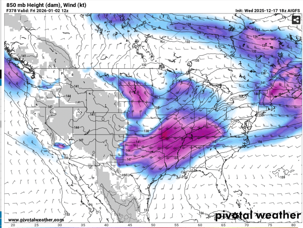
AIGFS is available on WxBell as of today....new product from the NWS and Co. The NWS version has the AI-GFS, AI-GEFS, AI-Hybrid(includes current GFS which is combined with the AI model). NOAA has launched a groundbreaking new suite of operational, artificial intelligence (AI)-driven global weather prediction models, marking a significant advancement in forecast speed, efficiency, and accuracy. The models will provide forecasters with faster delivery of more accurate guidance, while using a fraction of computational resources. AI-driven global weather models -
December 2025 regional war/obs/disco thread
Damage In Tolland replied to Torch Tiger's topic in New England
We’ve always said .. at least screamers bring exciting weather, damage etc. If you’re gonna lose pack .. at least have it come with some exciting weather -
pacific is just more powerful than the atlantic
-
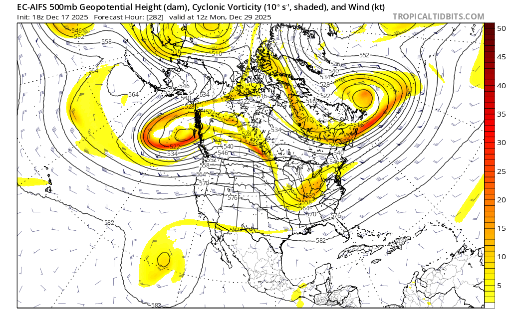
Euro AI is rain to snow. Block and confluence flexing and forcing. I don't have high hopes for anything until the pac trough backs off but to get something to work we need a gnarly block and all models are showing something to that effect.

-

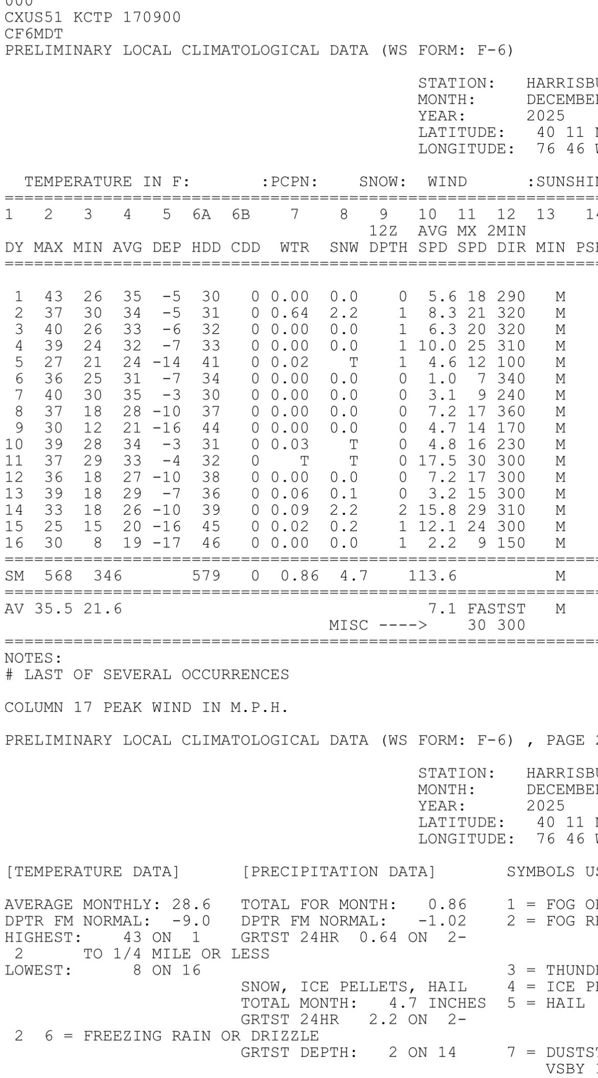
Central PA Winter 25/26 Discussion and Obs
Blizzard of 93 replied to MAG5035's topic in Upstate New York/Pennsylvania
It is truly remarkable that MDT is running 9 degrees below normal temperature for the month through 12/16. What a cold stretch, along with above normal snow for the season to date at 4.7 inches. Great start to the season & hopefully we are on our way to a good Winter that is overdue for many of us.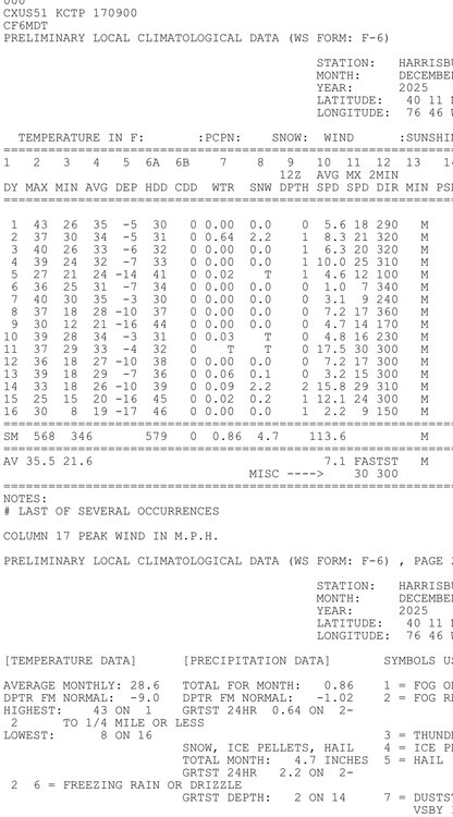
-
12/29-30 is probably our best chance, but it's still a long shot. OPs have been showing ways we can score for a decent amount of time and ensembles have a decent signal, but we're kinda grasping on straws here lol. EPS shows that kind of ugly central-US ridge, but it also shows an pretty strong east-based -NAO. Even though it's a -NAO, it's an east-based -NAO, so while it'll help with a torch it's not going to do much otherwise IMO. h5 flow would suggest WAA aloft but at least it's somewhat cold at the surface so snow changing to mix or rain has a decent chance. More of a conditional setup where timing is absolutely key, so wouldn't hold too much hope unless the -PNA/+EPO trends towards neutrality and/or that NAO block trends more west. We still have time though, 288 hours is more than enough time for those things to happen.