All Activity
- Past hour
-
Ya it's been a pretty deep Winter here for sure.
-
Dude just go to Rehoboth. There will be plenty of snow there, and actually places to go for good food and drinkies. You will get great shots and vids walking down Rehoboth Ave to the beach. And ofc right at the beach. I'm telling ya. Book it and go now.
-
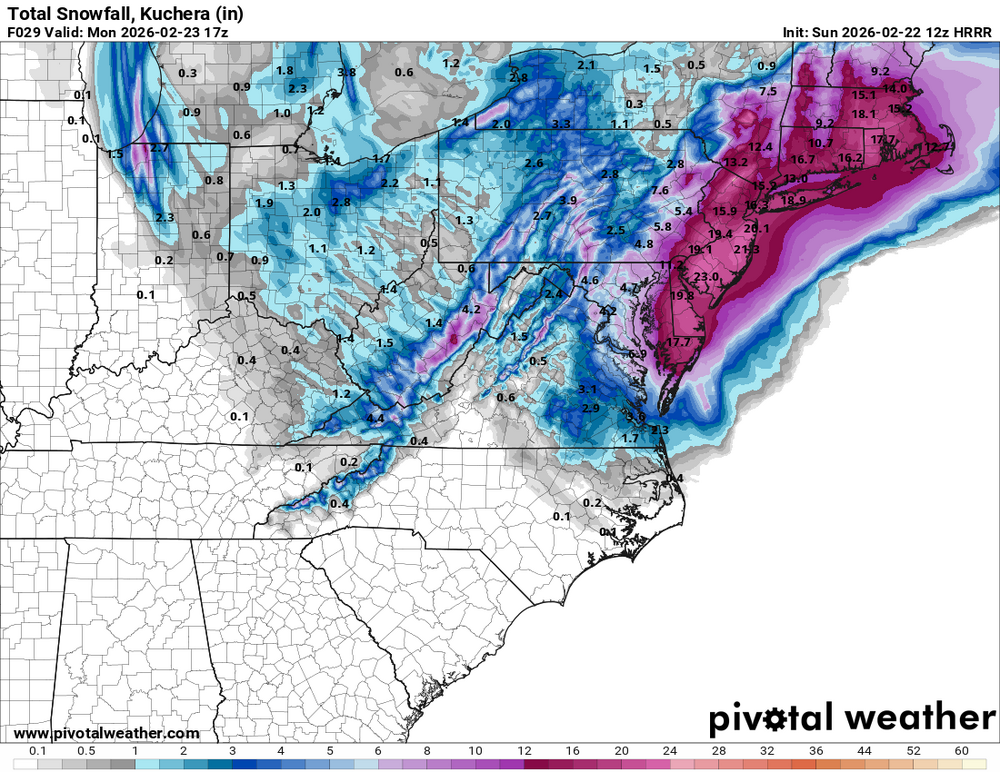
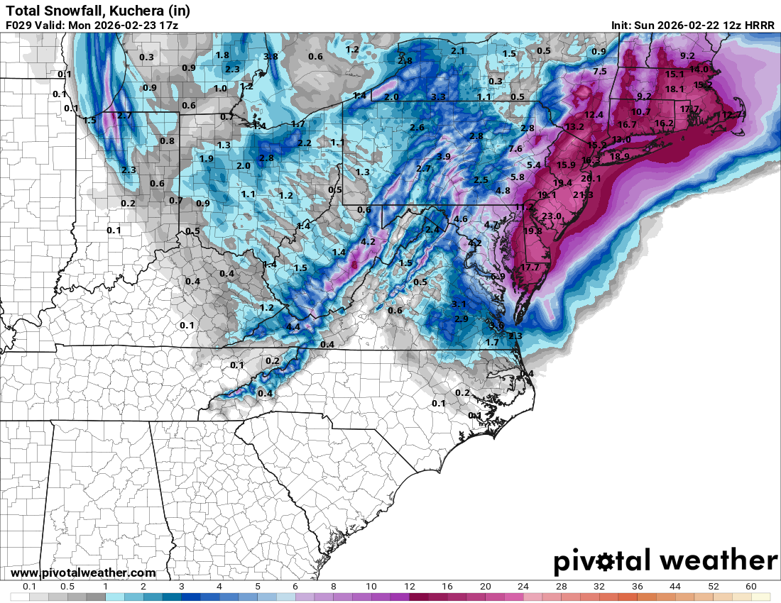
a bit east which affects western sections
-
Lots places in DE/NJ once you get inland are forecast to get 18-25 inches, along with some strong winds. Man DailyLurker, I envy you with all my heart.
-

“Cory’s in NYC! Let’s HECS!” Feb. 22-24 Disco
TheSnowman replied to TheSnowman's topic in New England
2 For 2 and you guys BITCHED AT ME BOTH TIMES for starting the Threads!! -
36 is a stretch. I don’t believe these big totals are as widespread as forecasted
-
32 in Smithsburg now with snow mixing in. I'm at about 750ft in elevation. Looks like the Catoctins are getting hammered right now.
-
-

Feb 22nd/23rd "There's no way..." Obs Thread
midatlanticweather replied to Maestrobjwa's topic in Mid Atlantic
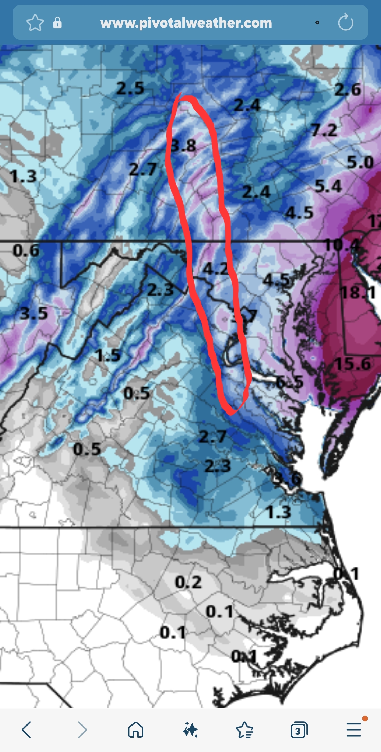
Looks like the short term are seeing the norlun here. It seems to have shifted east since last night but was about there on the Euro as well.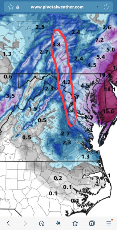
-

Feb 22nd/23rd "There's no way..." Obs Thread
87storms replied to Maestrobjwa's topic in Mid Atlantic
Light accumulation of puddles here. -
This is the exact kind of storm where the Lehigh Valley can get screwed by the geography of the area. Hi-res models have been hinting at this ever since they came into range, including the latest HRRR which gives the Poconos and Philly burbs 12-18” yet Allentown struggles to get to 6”. The same thing happened here during Boxing Day, although this one doesn’t look like as big of a bust. Hopefully.
-
That goal was a thing of beauty
-
Feb 22nd/23rd "There's no way..." Obs Thread
Imgoinhungry replied to Maestrobjwa's topic in Mid Atlantic
Dc metro schools closed id think. WSW warning through 10am . -
feathers falling. 35.
-
Rates are winning right now. All non-paved surfaces are covered. Down to 34°.
-

Feb 22nd/23rd "There's no way..." Obs Thread
NorthArlington101 replied to Maestrobjwa's topic in Mid Atlantic
Well, I'd be hoping this is an easier plow. But thanks. Might dissuade me. -
I am going with 8" to 12" out here in NW Chesco Currently Mist and 34.3 degrees
-
37 and 0.12" of rain so far What's the weenie rule for wet, warm ground? Subtract a couple inches?
-

“Cory’s in NYC! Let’s HECS!” Feb. 22-24 Disco
WinterWolf replied to TheSnowman's topic in New England
Don’t really know how to read those…could you explain what that shows Seymour? -
Feb 22nd/23rd "There's no way..." Obs Thread
Imgoinhungry replied to Maestrobjwa's topic in Mid Atlantic
36 and steady rain in SE frederick. . -
First flakes at 8:15 at 34.6. 115 miles wsw of D.C..
-

Feb 22nd/23rd "There's no way..." Obs Thread
davidjd1114 replied to Maestrobjwa's topic in Mid Atlantic
Lmao thanks for the heads up . -

Feb 22nd/23rd "There's no way..." Obs Thread
Terpeast replied to Maestrobjwa's topic in Mid Atlantic
It doesn’t flip us until 22z (5 pm) and still gives us 6” give or take -

Feb 22nd/23rd "There's no way..." Obs Thread
Eskimo Joe replied to Maestrobjwa's topic in Mid Atlantic
Camp David reporting heavy snow and an indefinite sky. Might be a decent sign that it's cold right off the surface and we won't waste *too* much time flipping once heavier returns get in here. While the Camp David ASOS is around 1,800 feet, the Thurmont mesonet site is in town at a much lower elevation and they're about to hit 32 degrees. Looks like the colder air might be trying to win out? -

Feb 22nd/23rd "There's no way..." Obs Thread
clueless replied to Maestrobjwa's topic in Mid Atlantic
What will be the call for schools and local governments tomorrow?


(002).thumb.png.6e3d9d46bca5fe41aab7a74871dd8af8.png)


