All Activity
- Past hour
-
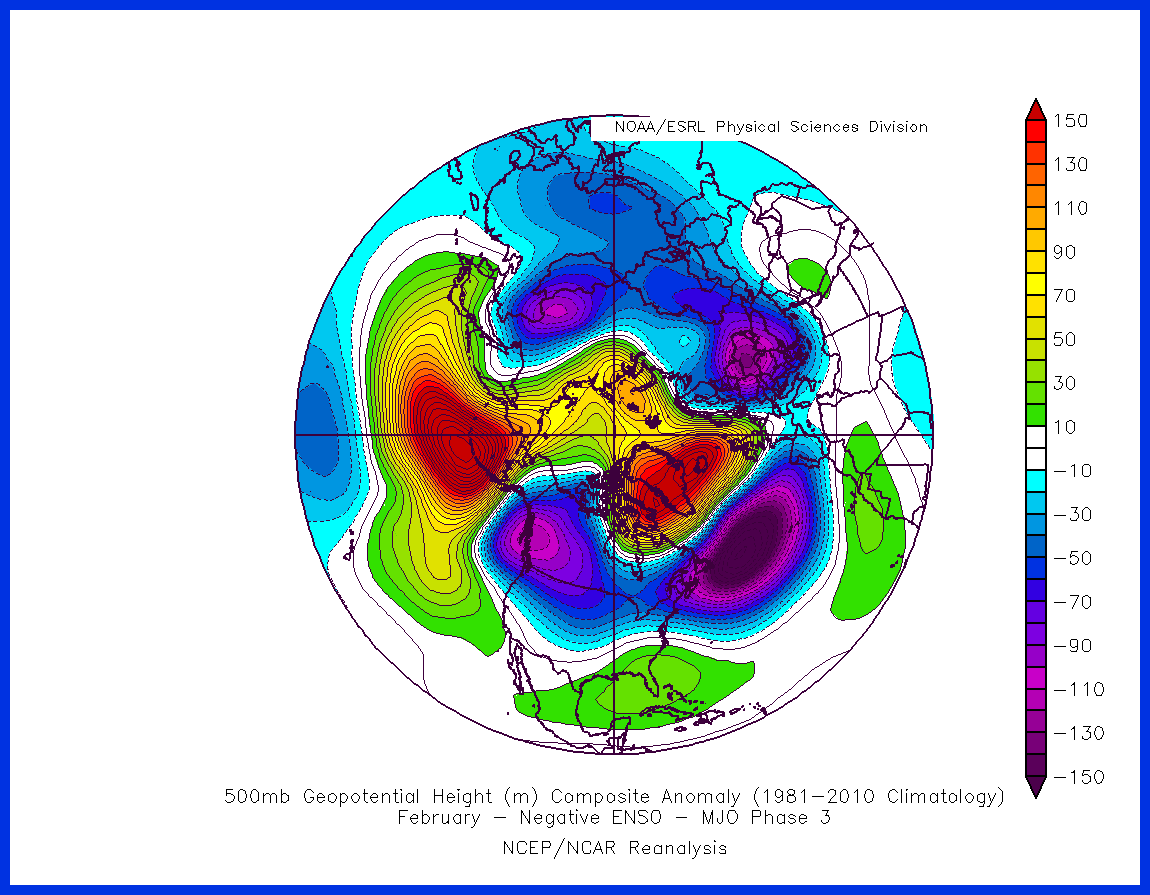
 This last cold pattern was impressive though? There is a middle ground in there.. we are just changing states in the Pacific pretty extremely, from what I see on models today and the last few days. +400dm Aleutian ridge with sub-5000dm heights in Alaska is one extreme. It's not like we are borderline favorable and it's always going warm.. we are just in pattern flux for the last several years.
 -
 Which is my point. It used to be cold enough to overcome imperfections in patterns. I’ll give you an example. When I looked at every 5”+ snow at Baltimore from 1948 on there was a subset of storms in fall Hudson Bay high storms. Because the whole pattern was utter dog shit except for that one feature. Because a high there tended to force a favorable storm track and almost all these storms were warm and barely cold enough to snow. The most recent example was 1997. A horrible pattern. -pna. But we got an 8” wet snow storm when it was like 45-50 the day before and after the storm. But those have gone extinct. Now they are just perfect track rainstorms. Lately when the pattern isn’t perfect it’s too warm.
 -

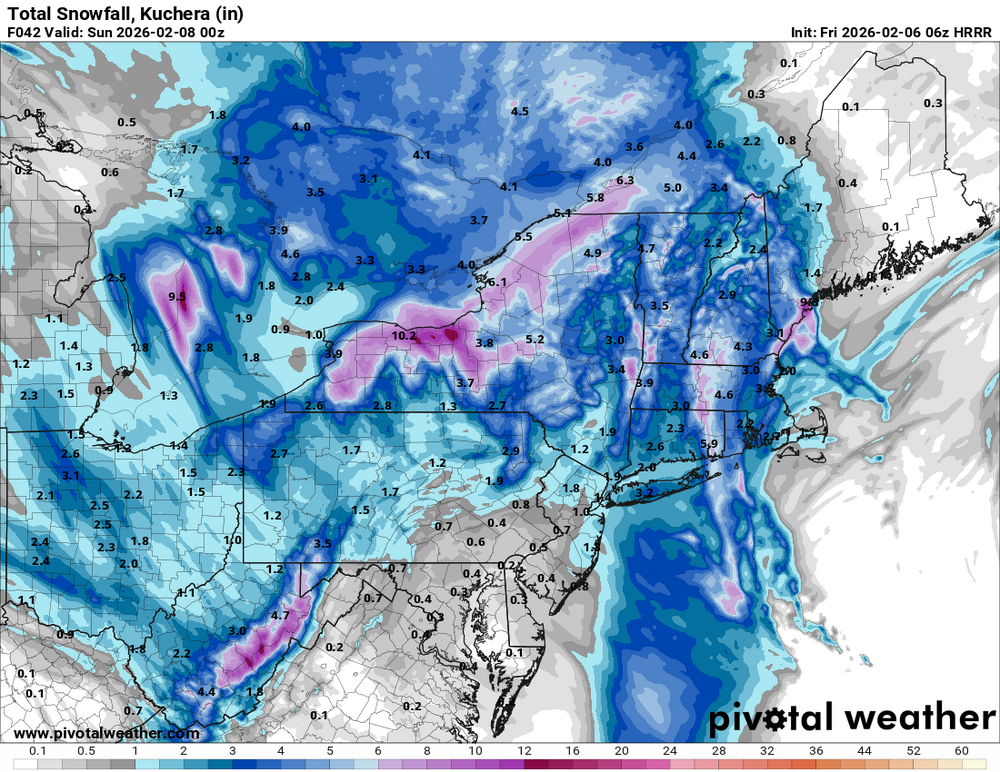
Friday February 6 FROPA / WINDEX small event
ineedsnow replied to HoarfrostHubb's topic in New England
-
Friday February 6 FROPA / WINDEX small event
ineedsnow replied to HoarfrostHubb's topic in New England
6z HRRR beefing up here!! We take -
Friday February 6 FROPA / WINDEX small event
ineedsnow replied to HoarfrostHubb's topic in New England
0z really beefed up more.. let's continue the trend -
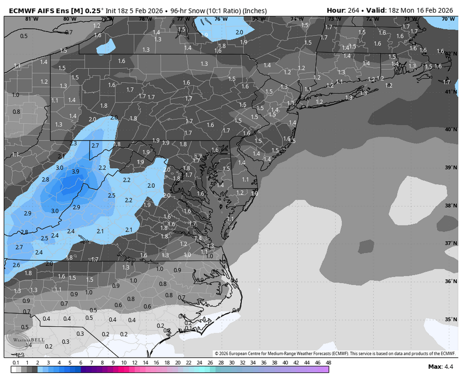
How much snow are we averaging in Feb-March during this stretch? This is even with ridging extending into Alaska - replace that AK anomaly with a trough and it turns into a nightmare. March 2018 is probably the only big snow, and had a much stronger -NAO than what is being projected.
-
Currently, 22.1 and the two cats are staying inside.
-
URGENT - WEATHER MESSAGE National Weather Service Baltimore MD/Washington DC 219 AM EST Fri Feb 6 2026 DCZ001-MDZ013-014-016>018-504-VAZ053-054-501-505-506-526-527-061530- /O.CON.KLWX.HW.W.0001.260207T0900Z-260208T0000Z/ /O.CON.KLWX.CW.Y.0011.260207T0900Z-260208T1500Z/ District of Columbia-Prince Georges-Anne Arundel-Charles-St. Marys-Calvert-Central and Southeast Montgomery-Fairfax- Arlington/Falls Church/Alexandria-Northern Fauquier-Western Loudoun-Eastern Loudoun-Northwest Prince William-Central and Southeast Prince William/Manassas/Manassas Park- 219 AM EST Fri Feb 6 2026 ...HIGH WIND WARNING REMAINS IN EFFECT FROM 4 AM TO 7 PM EST SATURDAY... ...COLD WEATHER ADVISORY REMAINS IN EFFECT FROM 4 AM SATURDAY TO 10 AM EST SUNDAY... * WHAT...For the High Wind Warning, northwest winds 20 to 30 mph with gusts up to 60 mph expected. For the Cold Weather Advisory, very cold wind chills as low as 13 below expected. * WHERE...Portions of DC, central and southern Maryland, and northern Virginia. * WHEN...For the High Wind Warning, from 4 AM to 7 PM EST Saturday. For the Cold Weather Advisory, from 4 AM Saturday to 10 AM EST Sunday. * IMPACTS...Damaging winds will blow down trees and power lines. Widespread power outages are expected. Travel will be difficult, especially for high profile vehicles. The cold wind chills as low as 15 below zero could result in hypothermia if precautions are not taken. * ADDITIONAL DETAILS...Wind chills will remain at or below zero during the day on Saturday due to windy conditions and cold temperatures. PRECAUTIONARY/PREPAREDNESS ACTIONS... Remain in the lower levels of your home during the windstorm, and avoid windows. Watch for falling debris and tree limbs. Use caution if you must drive. Use caution while traveling outside. Wear appropriate clothing, a hat, and gloves. Keep pets indoors as much as possible. Make sure outdoor animals have a warm, dry shelter, food, and unfrozen water. && $$
- Today
-
Maybe but the pattern has been batting a near perfect average for the last 7-8 years
-

Friday February 6 FROPA / WINDEX small event
Roger Smith replied to HoarfrostHubb's topic in New England
Thought I was in the cold weather discussion for some reason. More general comment, this will be a low pressure system with no real warm sector, there's never a notable rise in thickness before it begins to fall off during the IVT formation Friday night. It will be a case of cold air becoming saturated then a stronger northerly wind setting in, as temperatures drop further. Peak temperatures may only be around 25-28 F for many as the snow begins to fall. This low is going to lose its identity while the coastal develops and a "norlun" or IVT forms. Interesting evolution. 2-4" snow potential in places given that ratios will be quite good (15 to 20 : 1 ) Note there is some very cold air in central Quebec waiting to push into this developing IVT and that may cancel out any WAA from the west-northwest. Watch temperature trends in Ohio and Pennsylvania as the dying low approaches. -
dt says next couple of weeks going to be bad if you want snow in the east
-
I could show you dozens of examples of snowstorms with a similar look
-
 WB 0Z AI EPS ticked upward compared to 18Z.
-
After we were just in the 10s and 20s for 2 weeks? The Pacific pattern is unfavorable dude, not just the PNA but the orientation of it with a strong trough over the top and to the NE.. floods with the US with warm air.
-

Central PA Winter 25/26 Discussion and Obs
pasnownut replied to MAG5035's topic in Upstate New York/Pennsylvania
Overnighters look to have flattened the flow, which makes more sense to me. While nao and ao are on the rise,both still in - territory next week. Add to it - pna, a flatter look seems reasonable. Beyond that...dunno, but next week still doesnt look bigly warm to me. Every week we add to this awesome stretch is fine by me. Spring will be springin soon enough and it'll make the warmth feel gooder. Headed north in a few hours. Have a great weekend all. Bundle up and enjoy the snow. -
The last 2 days I’ve been in the areas where the ice storm was most severe. It will take months to clean up all the trees & power poles. It’s much worse than the 94 ice storm. Many roads are 1 lane still from trees down everywhere. The ground being beyond saturated is also making it very difficult to get into areas to remove debris & trees.
-
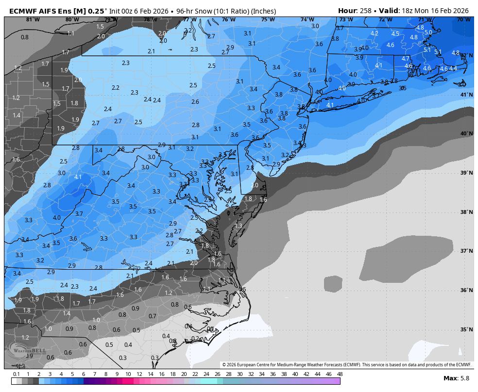
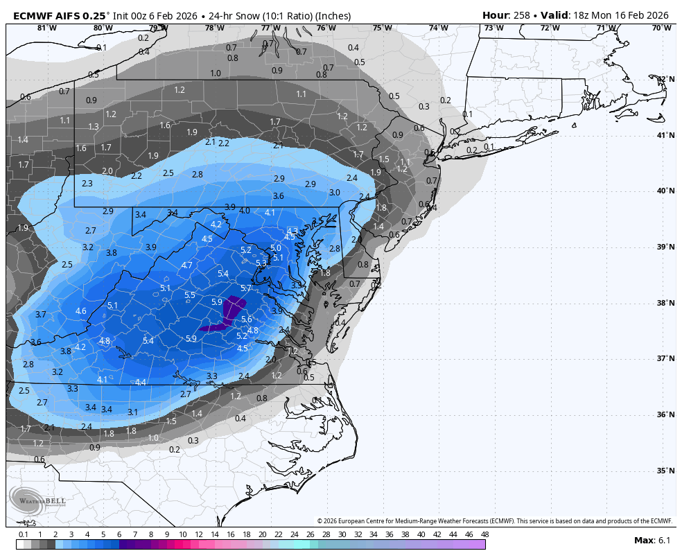
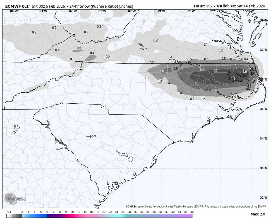
0Z Euro: nice snow NE NC AM of Feb 13th:
-
That’s not going to happen…but if it did, mid Feb, with a cold N Amer profile, a block and 50/50, and a perfect track rainstorm…I have the final chapter of my book
-
That reminds me, I should take some more shots of the Clinch before the warm up. It will be the most iced I have seen it since Feb 2015 (that's what got me first lurking on amwx) where in select portions it wholly froze over at the bends. Maybe some good shot opportunities on Lake Witten or Hayters Gap too if they've been plowed. I'd try Hidden Valley or Laurel Bed but that's probably an insurance premium nuke if I've seen one haha.
-

2025-2026 ENSO
so_whats_happening replied to 40/70 Benchmark's topic in Weather Forecasting and Discussion
Unfortunately those 10 or so days were not all that fun for here. Eastern NC though I'm sure was just in love with this pattern lol. From the looks of the Nina phase 1 passage is taking place this weekend. Large cold dump with warming through much of the plains showing up. Going forward it does show cold building back up into Canada to be unleashed again at some point maybe the last week or so of February into early March as we move into Phase 2/3?

-

February 2026 Medium/ Long Range Discussion: 150K Salary Needed to Post
bncho replied to Weather Will's topic in Mid Atlantic
Euro AI has some PD action
-
Yes,its been like that for whatever reasons North of 1-40 seemingly the last couple decades,its the battle ground and we 90% of the time,lose
-
 Canadians got a storm [emoji1063] .
 -

Richmond Metro/Hampton Roads Area Discussion
TampaMan replied to RIC Airport's topic in Mid Atlantic
Y'all should just start naming threads like they do.. they already do it... do it!!! -
Ar aghaidh linn! https://www.tropicaltidbits.com/analysis/models/?model=gfs®ion=neus&pkg=mslp_pcpn_frzn&runtime=2026020600&fh=138