All Activity
- Past hour
-
Oh no, it was wet, so it counts!! Here I woke up to clear/sunny skies and a cool/pleasant 34.4 low.
-
That is why I bought it from Amazon. If I can't get everything working, I can return it easier. I think that part goes outside (and I'll place it into the solar shield) and if I do it correctly, it will be synced to the console. I hope it works, but I'll let you know either way.
-
Let me know if you're able to sync it. And what do you do with the little handheld part? You just leave it outside in the elements? And it just gets powered by double AAs? I don't get that part.
-
My numbers for the month of October 2025. Averaged high was 66.1 degrees vs a normal of 66.9 degrees, -0.8 degrees below average. The warmest day was the 7th with a 79.4 degree reading. Averaged low for the month was 41.5 degrees vs a normal of 41.5 degrees, a perfect match. The coldest temp recorded was 29.0 degrees on the 26th. Overall averaged temp was 53.8 degrees vs a normal of 54.2 degrees, -0.4 degrees below average. Total rainfall was 2.19 inches vs a normal of 2.70 inches, -0.51 inches below average. The wettest day was the 30th with 0.93 inches falling. There were 8 days with measurable, 3 days with a 'T' and 20 dry days. Highest wind recorded was on the 20th at 38 mph. No new records for the month. Overall, a fairly average October. Rainfall barely broke into 80 percent of average, only because 82% of the 2.19 inches fell on two days, the 8th and 30th, rest of month was quite dry.
-

2025-2026 ENSO
40/70 Benchmark replied to 40/70 Benchmark's topic in Weather Forecasting and Discussion
2024, sure.....this won't be like December 2023. It's not going to be that mild. -

November 2025 general discussions and probable topic derailings ...
weatherwiz replied to Typhoon Tip's topic in New England
Well 12z GFS did not really back down. But as a reference for what is being discussed, here is a point-and-click sounding from within northeast Connecticut. That is a very well mixed lowest 1km (nearly dry adiabatic) with 50+ knot winds at 850mb. Very dry below the 850mb level too which would further enhance downward momentum. -
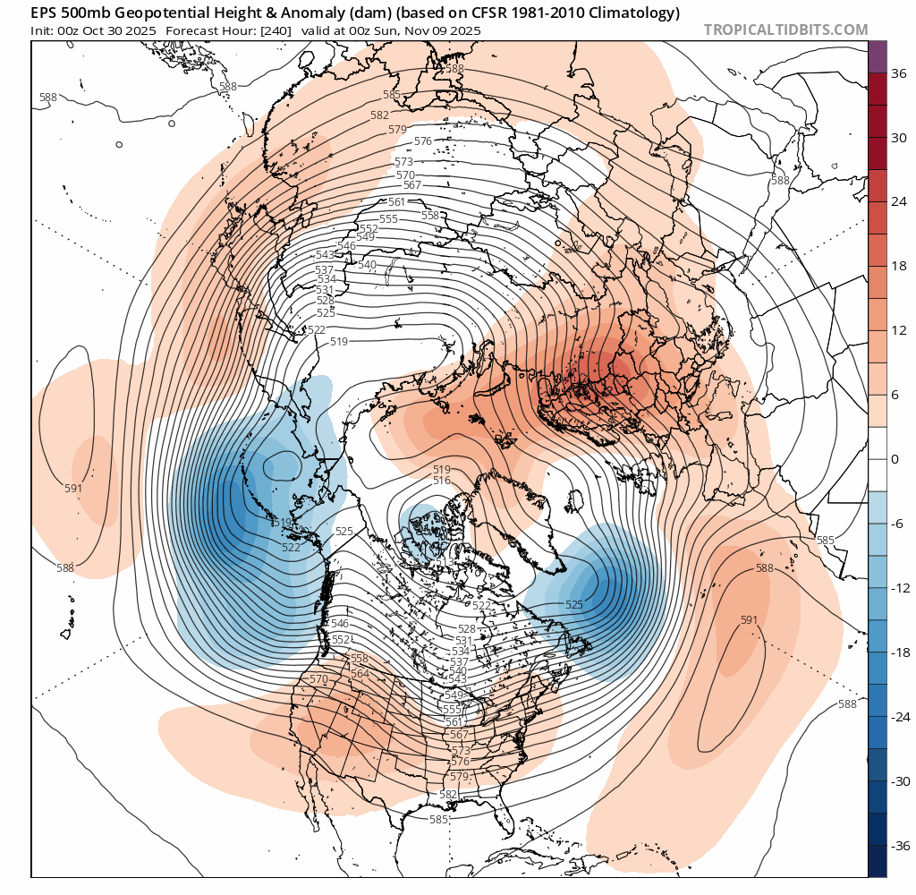
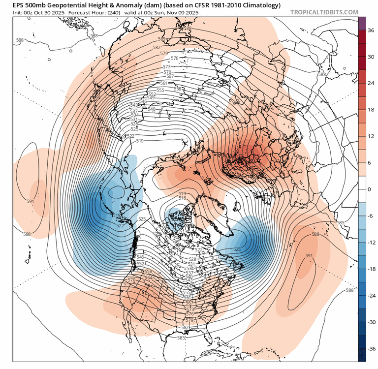
Speaking of Conus troughs: After having a few chilly runs in late Oct in the E US for the period around Veteran’s Day and then backing off to mild, the model consensus since Nov 1st has gotten much colder for then with the last few runs being the coldest yet! Check out this EPS progression for 0Z on Nov 9th from the 0Z 10/30 run through the 0Z 11/3 run: check out the big rise in Greenland heights along with the increased +PNA intensity: this shows that models out 10 days were clueless!
-
I feel like we can start off with the base state when making predictions for early winter. Until that PacJet slows down and we can get bigger troughs moving into CONUS, I think early winter would be quite muted across CONUS similar to the very inactive (in the winter weather department) December 2023 and December 2024 and some of those same problems trickled down through the rest of those winters.
-
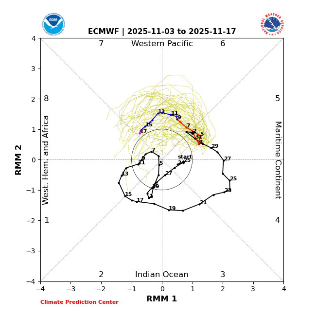
The ACCESS BOM from Australia when I checked yesterday argued it does not really make it heavily into 7 and definitely not 8. I have found that model sometimes is better than the EPS/GEFS for the MJO in the longer range
-
 Seems like deja vu where you have a storm track that looks somewhat promising in the 7-10 day range that shifts north with time and ends up traversing the Lakes to NNE/Southern Ontario. Meh.
 -
Yeah we're starting out warm too, with temps in the 60s for most of this year. And a fast PacJet will prevent any arctic air from being pulled from the north. That's why the models have showed colder air and wintry weather towards middle of month but in due time, that will likely be diminished due to lack of cold air at the same time the northern stream energy comes through.
-

November 2025 general discussions and probable topic derailings ...
powderfreak replied to Typhoon Tip's topic in New England
6” at the summit stake for depth. It looks a lot nicer than it really is (2-6” of dense snow). But in early November the look works. -
I think it does get into phase 6/7. My big question is what happens when it reaches 7
-
After having a few chilly runs in late Oct for the period around Veteran’s Day and then backing off to mild, the model consensus since Nov 1st has gotten much colder for then with the last few runs being the coldest yet!
-

November 2025 general discussions and probable topic derailings ...
WinterWolf replied to Typhoon Tip's topic in New England
Actually you are so correct. But I’ll go out on a limb here and say that will certainly tone down…99% of the time it does. Unless this is the 1 percenter? -

E PA/NJ/DE Autumn 2025 Obs/Discussion
The Iceman replied to PhiEaglesfan712's topic in Philadelphia Region
regardless of snow, looks like a decent cold shot across all guidance around the 10-12th. A bit OT but i started reading this last night to get into the winter spirit: https://www.goodreads.com/book/show/61272028-northeaster highly recommend it for any other weather history buffs out there. It's an enjoyable read so far about a storm I really knew nothing about. -

November 2025 general discussions and probable topic derailings ...
BrianW replied to Typhoon Tip's topic in New England
I think they radiate well there with the sandy soil. HVN and BDR were in the mid 40s most of the night. -

November 2025 general discussions and probable topic derailings ...
Lava Rock replied to Typhoon Tip's topic in New England
looks great. how much and was that from Sat? -
November 2025 general discussions and probable topic derailings ...
powderfreak replied to Typhoon Tip's topic in New England
November.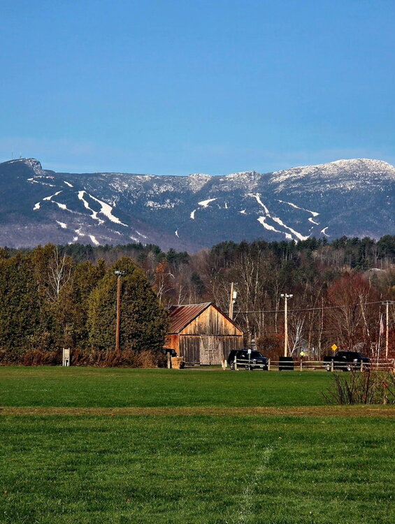
-
Yes. So, even if there’s no more ACE, 2025 will end above the 1991-2020 average of 122.
-
We are at 132.6 total ACE now?
-
 Groton taking the crown of coldest coastal spot in CT so far this fall.
 -
Eps had a bit of a nod to the Gefs ideas with the MJO at 00z.
-
Just 0.02" here.
-

November 2025 general discussions and probable topic derailings ...
kdxken replied to Typhoon Tip's topic in New England
Can you add an angry emoji please. Sad doesn't cut it.