All Activity
- Past hour
-
Mesos have some action tomorrow night
-
If we can make it to 103 here, having a low of -7 earlier this year, the 110 degree range is one of the largest I can think of since I've been tracking.
-
CT is just a rest stop between Boston and NYC.
-
Wednesday looks pretty solid
-
Watch 'em get 30 foot corn stalks along that line
-

Fireworks Heat Contest W 7/1 - S 7/4 for Five MA Airports
WxUSAF replied to nw baltimore wx's topic in Mid Atlantic
DCA: 98, 101, 100, 97 BWI: 97, 102, 101, 97 IAD: 96, 99, 98, 96 SBY: 97, 100, 99, 98 RIC: 98, 100, 100, 98 Rain: 0.45” -
Having lived in North Dakota for a decade, this is spot on. With heat, once you're naked or have loose all white clothing on, there's nothing else you can do. With cold, just put on more layers. I will take -10 / -10 vs. 100/75 any day. Can you believe I have to work with this guy?
-

Junorch obs and discussion 2026
Damage In Tolland replied to Damage In Tolland's topic in New England
Seems like Tuesday and Friday are best shots. EML in place late week. If we can derecho and blows groves of forests down and/or blow windows out of buildings, most folks should be happy. With you in BOX this week, we expect to see some acknowledgment of their CT counties rather than AEMRIATT -
Rough morning for this DOT station. Temp sensor blown into a tractor trailer diesel exhaust? https://mesowest.utah.edu/cgi-bin/droman/meso_base_dyn.cgi?stn=SD607&time=GMT
-

E PA/NJ/DE Summer 2026 Obs/Discussion
JTA66 replied to PhiEaglesfan712's topic in Philadelphia Region
Heard a lone cicada on this morning's Jebwalk. Seems a little early in the season, so maybe he's just an early riser. Finished with 1.05" last evening. I'm sure most was just run off, but hopefully whatever the lawn was able to absorb will help it survive the week. 70F/DP 69F -
My phones weather app doesn't have a single day at 100 or above for CLT now. (Yes I know its not accurate but hey Im trying to be positive lol) There is like 4 99 degree days in a row on there so not much difference but it beats the 103 and 104's that were being posted last week that I haven't really seen any of lately.
-

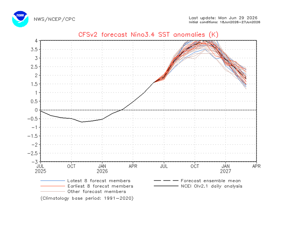
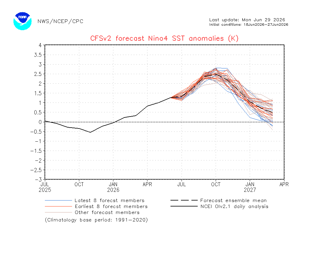
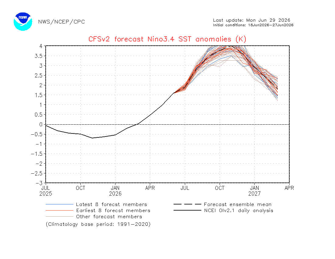
2026-2027 Super El Nino
GaWx replied to Stormchaserchuck1's topic in Weather Forecasting and Discussion
The latest CFS has its warmest relative 3.4 monthly peak yet, way up at a record high obliterating +3.3 in Nov! But note that it also still cools it at a record rapid pace all the way down to +2.0 in Jan, +1.5 in Feb, and +1.0 in Mar: @PhiEaglesfan712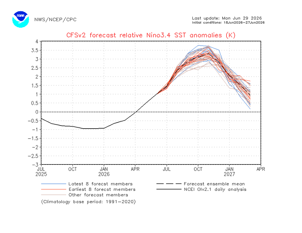
-
12z HRRR catching on to the 0z RRFS?
-
What winds can the radomes withstand before worrying about damage risk?
-
Some guidance suggest the first day of 90+ is actually tomorrow W-N of any s-breeze contamination. I feel some of the guidance is low balling by a couple of ticks overall. The Euro's inventing cu fields with transparent anvils ...enough to rob the top 3 or 4. With 590+ dm heights under a capping ridge (i.e. DVM offset) it seems that could wind up too liberal with cloud production. Little nuances like that. We'll see, but it wouldn't surprise me if 24 and 36 hours before each day in this Wed-Sat period, we see the polish on this return.
-
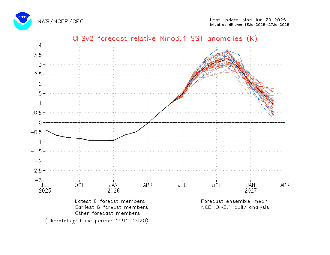
2026-2027 Super El Nino
GaWx replied to Stormchaserchuck1's topic in Weather Forecasting and Discussion
Updated relative weeklies: Midweek date……..1+2………3……..3.4……..4 29APR2026 0.6 0.4 0.4 0.5 06MAY2026 1.0 0.5 0.4 0.5 13MAY2026 1.3 0.6 0.4 0.6 20MAY2026 1.6 0.7 0.5 0.6 27MAY2026 1.7 0.8 0.5 0.7 03JUN2026 2.0 0.9 0.7 0.7 10JUN2026 2.1 1.0 0.9 0.8 17JUN2026 2.4 1.3 1.1 0.8 24JUN2026 2.5 1.5 1.2 0.6 -
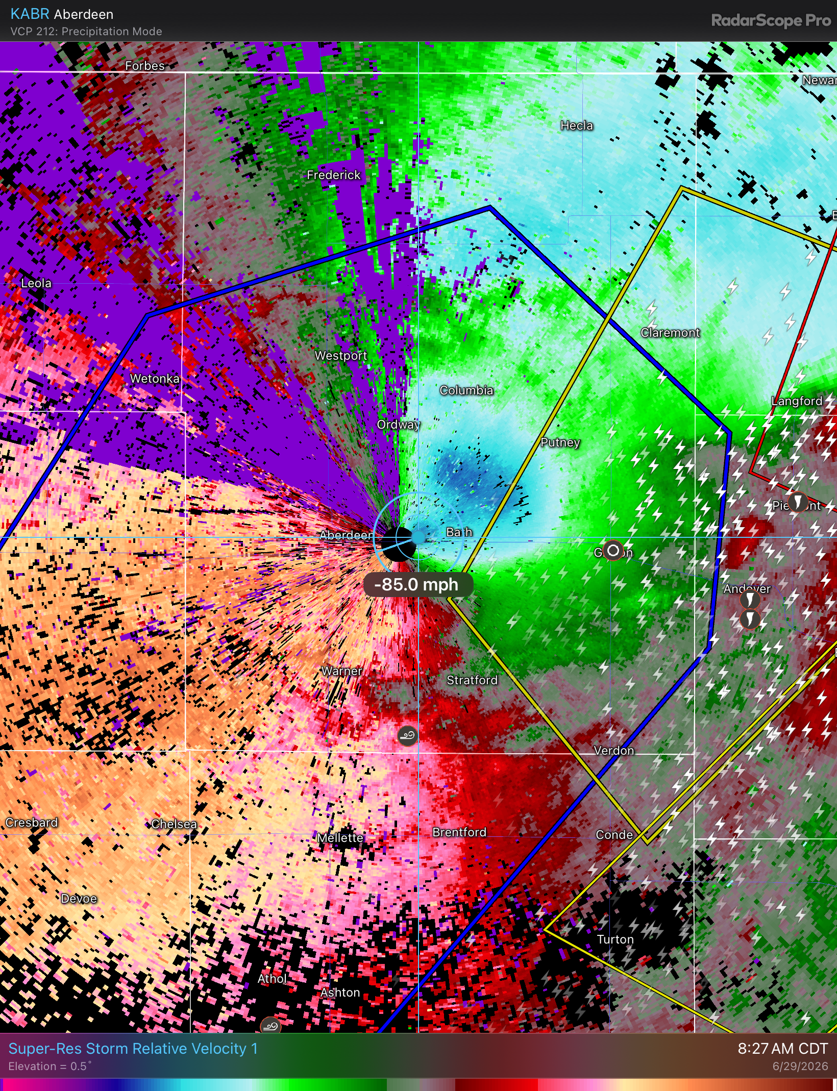
Maybe more impressive is that thing is just a ball of lightning. At its peak there were like 650-700 CGs in 5 minutes.
-
(002).thumb.png.6e3d9d46bca5fe41aab7a74871dd8af8.png)
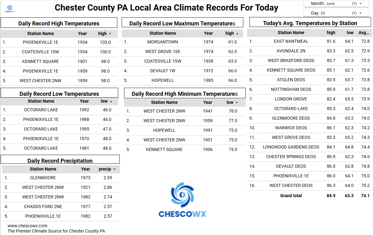
Central PA Summer 2026 Discussion/Obs Thread
ChescoWx replied to Voyager's topic in Upstate New York/Pennsylvania
Our extreme heat watch goes into effect starting on Wednesday. The next couple of days will be close to average for the end of June. Most spots should reach the low 90's starting on Wednesday with the peak hot days being both Thursday and Friday with highs in the upper 90's in most spots to near 100 in lower elevation valley locations. Storm chances increase a little on Independence Day and will help trim temperatures a little by the end of next weekend.

-
E PA/NJ/DE Summer 2026 Obs/Discussion
ChescoWx replied to PhiEaglesfan712's topic in Philadelphia Region
Our extreme heat watch goes into effect starting on Wednesday. The next couple of days will be close to average for the end of June. Most spots should reach the low 90's starting on Wednesday with the peak hot days being both Thursday and Friday with highs in the upper 90's in most spots to near 100 in lower elevation valley locations. Storm chances increase a little on Independence Day and will help trim temperatures a little by the end of next weekend.
-
Threat of severe every day I'm working at BOX? Let's see if I can't get Kevin his tree topper.
-
75kt ripping through the ABR radome at the last scan

-
I work Utility and definitely not looking forward to Wednesday and Thursday. Glad to have Friday and the weekend off.
-
If you want to really suffer, I hope you’re baling hay. 1980. Worst summer of my life.
-

2026-2027 Super El Nino
BlizzardWx replied to Stormchaserchuck1's topic in Weather Forecasting and Discussion
I think extra cloud cover from more open sea area and thus evaporation is a good candidate. But its also plausible it could be traced back to the same patterns driving the west Pacific warm pool/-PDO that has been dominant over most of this same period. Interesting to think about anyway. I am not totally sure we cool that area below 30C but it is possible. Perhaps more likely is if the area to the east is enough warmer, along with the circulation you mentioned, it can at least put a lid on convection near the MC. Then you'd at least have the dominant forcing away from 4-5-6. -

2026-2027 Super El Nino
LakePaste25 replied to Stormchaserchuck1's topic in Weather Forecasting and Discussion
Latest CFSv2 is more indicative of a basin-wide event. Have to keep an open mind here because I think basin-wide is def on the table (not just east-based).