All Activity
- Past hour
-
That storm is the first I really remember as a kid. Floating snow piles in the streets in Long Beach when the high tide came in. Crazy.
-
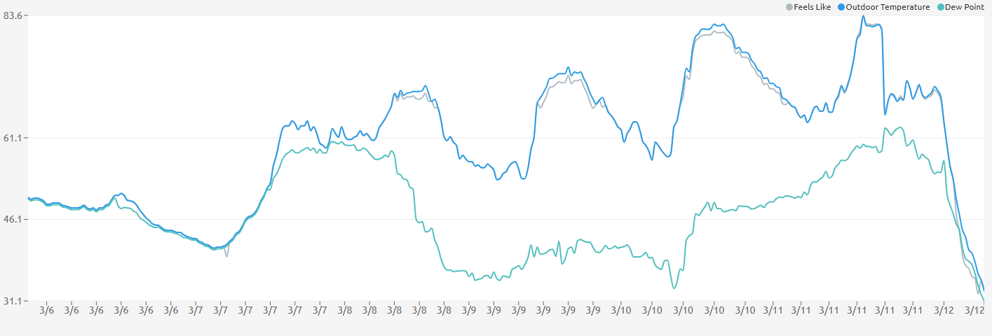
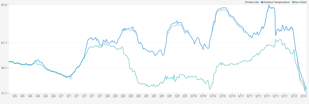
And again, all of this is happening after a midnight high of 73 in BWI, 77 in DCA and 76-77 in IAD.
-
80 Degrees to Ripping Snow: March 12th
Grothar of Herndon replied to SnowenOutThere's topic in Mid Atlantic
36/33 SN+ Fatties -
starting to stick here. 33
-
Legit steady snow in Rockville. Too bad we didn't have this with the last storm.
-
Snow in Colesville/Cloverly, 34°.
-
Sleet by Watkins Regional park in PG county
-

80 Degrees to Ripping Snow: March 12th
SnowGolfBro replied to SnowenOutThere's topic in Mid Atlantic
Sleet and rain mix in Montclair. Slush on deck -
If that 93 storm evolution had just been a little further eastward, by like 20-40 miles the storm effects and snow totals for this sub forum would have rivaled 1888.
-
winter feel outside lucky i took my hat gloves coat and hoodie..
-
42 right now
-
SNOW IN ANNANDALE LETS FUCKIN GO!
-
Western Howard County must get getting slammed. Wet bulb temp at Lisbon mesonet site plummeted to 25 degrees.
-
SW of Leesburg: Big drop yesterday was storm line. Now down to 32.7 and snowing hard.
-
48/38
-
Rippage!!
-
After being 56 at 7:45 now mixing with flakes here at 35.9. Looks like the good stuff comes mid- late afternoon into evening
-
Some slushy deck stickage with heavier rates. 35.4 degrees. Also, surprising silence from that Eagles fan guy.
-
The latest from airports: DCA 39 IAD 36 light snow BWI 37 rain/snow
-
It’s indeed ripping fatties at 37 degrees
-
lol had totally forgotten this
-

Rain/Thunder and Anafrontal Snow
Brian5671 replied to WeatherGeek2025's topic in New York City Metro
down to 42 here with off/on lite rain -

80 Degrees to Ripping Snow: March 12th
SnowenOutThere replied to SnowenOutThere's topic in Mid Atlantic
Man, if I didn't have my atmosphere and weather lab from 2-6 today I'd be out in Shenandoah today. Though, apparently we are launching a weather balloon in lab today which might get a pretty interesting sounding graph. -
surface temp now 42 at 11 am 10 miles west of Staten Island down from 54 around daybreak - no precip here Still no surface reports of anything frozen in PA at 11 am RWR from KCTP
-
Yuge Flakes in Garrison / Pikesville