All Activity
- Past hour
-

Winter 2025-26 Short Range Discussion
Chicago Storm replied to SchaumburgStormer's topic in Lakes/Ohio Valley
not sure why either. most guidance actually did very well in handling that narrow corridor of snowfall. -
Again, comical with the h5 differences vs 18z. Let's see where this goes
-
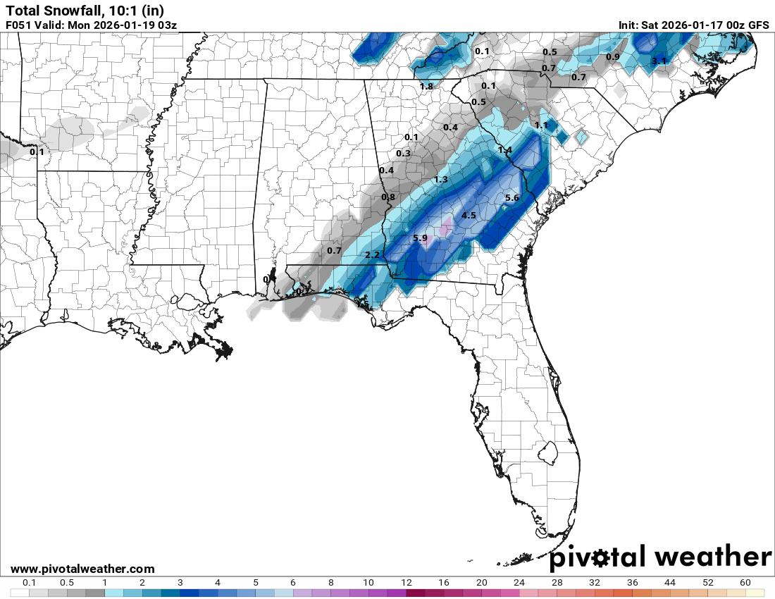
GFS seems more "smooshed" (scientific term) with the precip so far for the 23rd thing so far
-

Another Coating of Snow Saturday - "It's all we Got"
OrangeCTWX replied to Sey-Mour Snow's topic in New England
Not get when it’s last victory was like 13 years ago lol -
Kinda comical how the GFS h5 can change from run to run in under 100 hours. Euro kinda remains rock steady. But anyway, some changes upstairs, but seems minor.
-

E PA/NJ/DE Winter 2025-26 Obs/Discussion
RedSky replied to LVblizzard's topic in Philadelphia Region
Tomorrow's snow is bumping higher on 0z most guidance -
-

Storm potential January 17th-18th
WeatherGeek2025 replied to WeatherGeek2025's topic in New York City Metro
tomorrow looks good on cmc
-

First Legit Storm Potential of the Season Upon Us
8611Blizz replied to 40/70 Benchmark's topic in New England
-
Nothing really jumpin out so far. I'm enjoying a gin martini. 3rd one. How yall doing?
-
Storm potential January 17th-18th
WeatherGeek2025 replied to WeatherGeek2025's topic in New York City Metro
i'm trying to figure out how to put this guy and snowman (sound like the same people) on ignore -

First Legit Storm Potential of the Season Upon Us
TauntonBlizzard2013 replied to 40/70 Benchmark's topic in New England
Canadian weaker and SE. Please spare me the 1” of slop. I’d rather nothing -

Storm potential January 17th-18th
BoulderWX replied to WeatherGeek2025's topic in New York City Metro
Why are you looking at Sunday when Saturday is the better potential and it’s 12 hours away -

Jan 17-18 Sunday Funday Storm
gamecockinupstateSC replied to NorthHillsWx's topic in Southeastern States
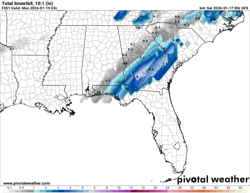
-
0Z GFS says dont punt, go for it on 4th down
-
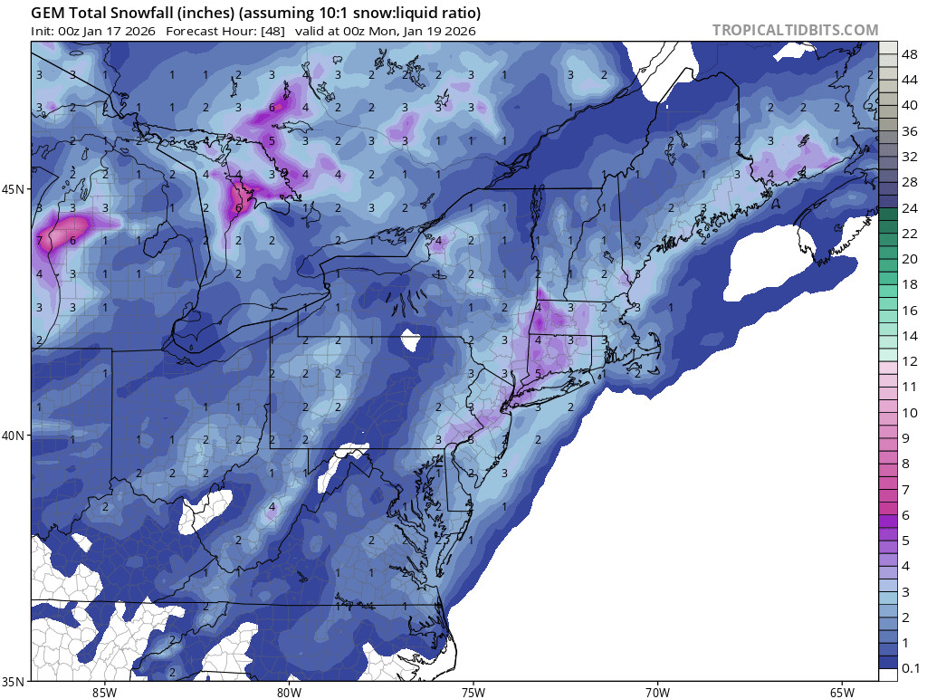
According to Ben Noll, only 19% of CONUS has average or above average snow thus far this season. Lowest since 2011-2012. I’m sure that’ll change soon but it shows how dry the US has been and warm (we in the Northeast and Midwest got lucky, it’s still been relatively cold). For rest of US, winter never got started at all.
-
ICON looked nice for the 22nd. GFS looks to be loading up the goods as well. We shall see
-
I'm legit wondering whether Baltimore is turning into that (at least temporarily). Like in what universe does S. Md do better than Baltimore for like 7 years?? Didn't these sliders used to come further north/northeast than this? I mean dang!
-
GFS is backing that thing up...
-

Winter 2025-2026 Offers Return to Normalcy
40/70 Benchmark replied to 40/70 Benchmark's topic in New England
First & Final Call For Two-Part Nuisance Holiday Weekend Snowfall Part One Saturday-Part Two Sunday Night Plowable Snowfall Likely Northwest on Saturday and Southeast on Sunday Night Eastern Mass Weather asserted late last week that a significant storm was highly unlikely to materialize on Friday into Saturday. However, there was a distinct possibility that the follow up wave could produce major winter storm this coming Sunday Monday, due in large part to subtle changes in the orientation of the western CONUS ridge. It now appears likely that significant snowfall on Sunday will be largely relegated to the southeastern thirds of the region, as intimated on Wednesday. Synoptic Overview Cold air infiltrated the region today behind yesterday's storm, setting the stage for a modest two-part snowfall over the region during this holiday weekend. It's a subtle reorientation to of the ridge near the west coast of the CONUS to a more negative tilt that allows the system on Sunday to amplify just enough to threaten a portion of the region with a light to moderate snowfall on Sunday night. However, before that takes place, a lead piece of vorticity (energy in the atmosphere) will pass over central New England during the day on Saturday. This will trigger a light southwesterly flow that that will advect some slightly milder air into the area, largely relegating accumulating snows to the northwestern half of the region, especially over the higher terrain. Once this system passes, colder air returns on Saturday evening as attention shifts to the approaching main portion of the amplifying incoming trough. The trough is going negative just soon enough to impact the majority of the region with significant snows. However, since the energy struggles to initially phase in a cohesive manner, there will be a limit to how much the system can amplify, as well as the northwest extent of significant snowfall. Expected Storm Evolution Part one in association with the lead energy spreads light snow into the northwestern half of the region on Saturday morning. It will become occasionally moderate over the higher terrain of the Berkshires during the middle portion of the day. Snow potentially spreads into eastern areas and ends as a rain/snow mixture during the late afternoon and early evening hours. There will then be a lull in the action overnight Saturday night through Sunday morning until mixed precipitation redevelops over the south coast, cape and islands around midday on Sunday and into the early afternoon. There should be some impact on the Patriot's playoff game, which may accentuate home field advantage, so dress accordingly. Precipitation will transition to snow from west to east over the cape and islands, as snowfall also overspreads the I 95 corridor while becoming steadier and more moderate. Snowfall should taper off around midnight from west-northwest to east-southeast. First & Final Call: -
Storm potential January 17th-18th
WeatherGeek2025 replied to WeatherGeek2025's topic in New York City Metro
you're forgetting GFS Ai and Euro Ai -
Hey imma be heading out to WV tomorrow! Further south in Cranberry Wilderness but excited to see snow again!
-
One thing that stuck out to me on that NAM and GFS run was this piece of energy is phasing with the southern part of the shortwave when it was not before. This amps the system up a bit more, earlier formation of the low pressure, and more lift to the north and west. Need 2 or 3 runs of trends back my way but could very well put a lot more people back in the goods. Now if Dr. No will just agree.
-
I'm fairly confident that's too far SE. Like 65%.
-
Would think that western edge of precip from the GFS will look better than modeled.