All Activity
- Past hour
-
Four tornado warnings in NC
-
Looks like it’s OTG again just northwest of RDU on 540
-
Time sensitive, but you can really see some decent convergence setting up in the western suburbs. Maybe angling for some heavier rain later on? https://mesonet.umd.edu/media/graphics/wspd_10m_plot.png?v=1791736880
-
They said mild PAC flow which is what it is . It’s one brief cool shot in and out . A brief of cool in a sea of warm. It’s not a deep cold long trough which is what was said . Look at the country
-
First flakes across New England next weekend? Kiss of death for winter?
-
System total is around 2.5” IMBY (estimating from outer Cocorahs gauge).
-
2.72 not sure ill make it to 3 but still a pretty significant event
-

Central PA Autumn 2026
Itstrainingtime replied to canderson's topic in Upstate New York/Pennsylvania
2.05" and raining. -
Hrrr shows an area of heavy stuff later circling the low. Whoever gets under that might pick up 1-2” more on top of whatever they got.
-
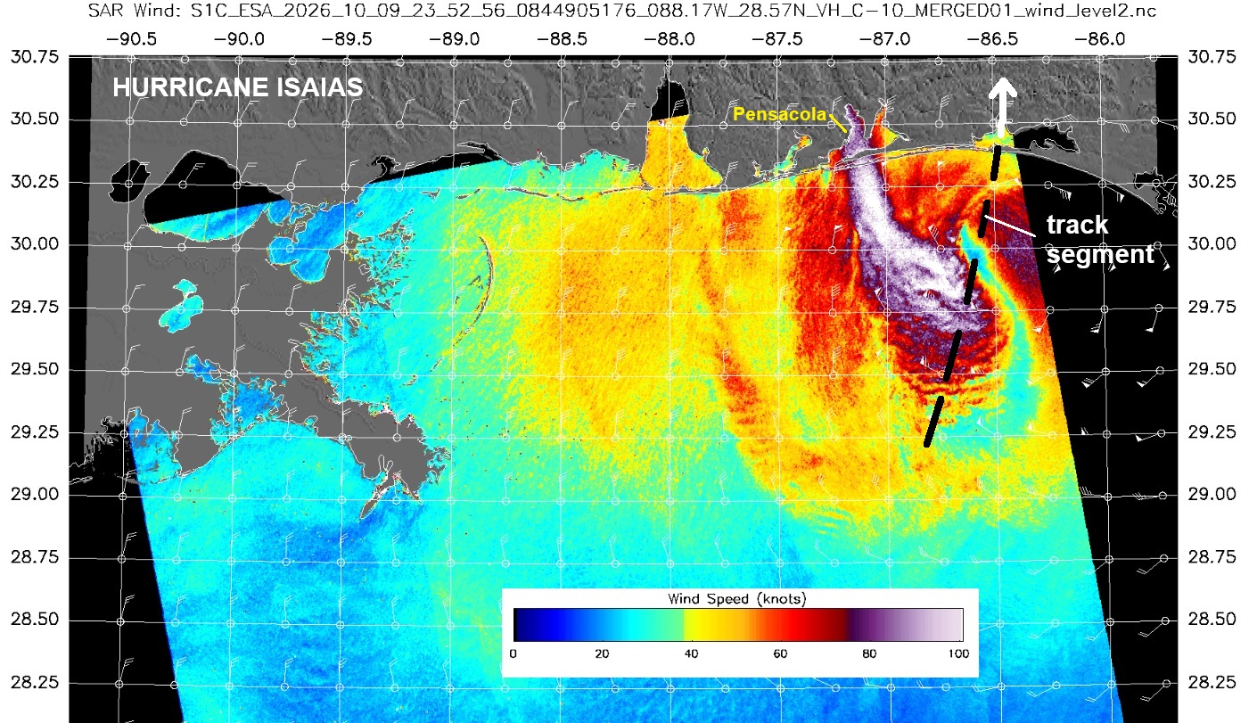
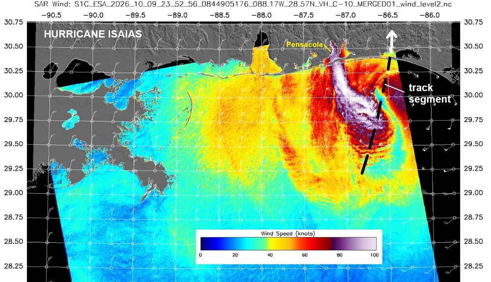
It did start its rapid weakening just before landfall. Now the sting development offset this somewhat, but a string jet is not a tropical feature. Posted this on the Tropical Forum. SAR imagery is DA BOMB! Enlightening for @CoastalWx? He proby will go, "how can I use SAR imagery to help me better for an impending or ongoing snowstorm?! Conventional GOES imagery SUX, I need something more!" ----- This SAR image clearly shows a sting jet, which is a characteristic of a PT/ET low pressure, not a TC. Also, prior to landfall, there was no coherent, focused wind center. It was quite elongated. So despite the satellite appearance w/ all the deep convection, structurally one could argue it had transitioned to more PT/ET than tropical prior to landfall. That sudden jump of pressure up 12 mb to 970 on recon when it has been holding steady 958-960 mb also indicates a rapid change structurally to away from tropical status. That suggested a distinct cool/dry air penetration into the core (front). Once that happens, a system is PT/ET. Note: SAR shows sustained winds max 110 kt. The SAR tends to have high bias. https://www.star.nesdis.noaa.gov/socd/mecb/sar/sarwinds_tropical.php?year=2026&storm=AL092026_ISAIAS I have always said when a system is transitioning like this, there should be a ramp down to subtropical status before PT/ET status. Why not? If a system can go from ET to ST to tropical, there is absolutely no reason to think it can not work the other way. This is what should have been done for Sandy for its landfall. A TC rarely goes instant PT/ET in just 6 hr. It is *process* that takes time. And I don't want to hear about the messaging issue. ST storms get names just like tropical storms, and the watches and warnings are the same ST or tropical. In fact, a few years ago, JTWC started assigning operationally ST status as systems transitioned from TC.
-
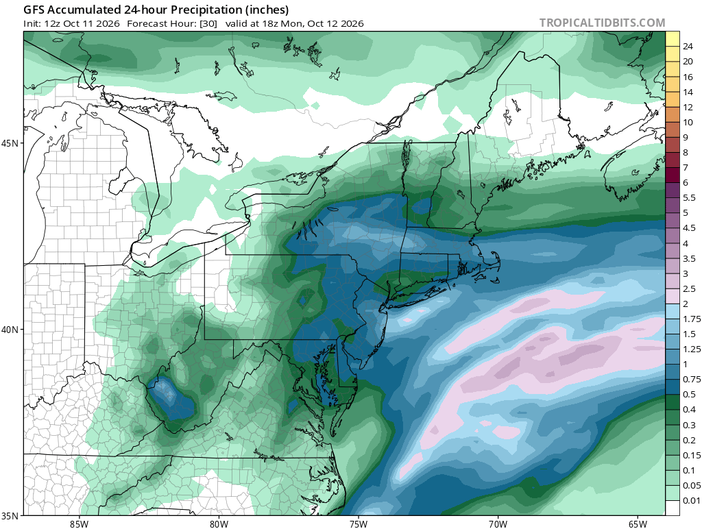
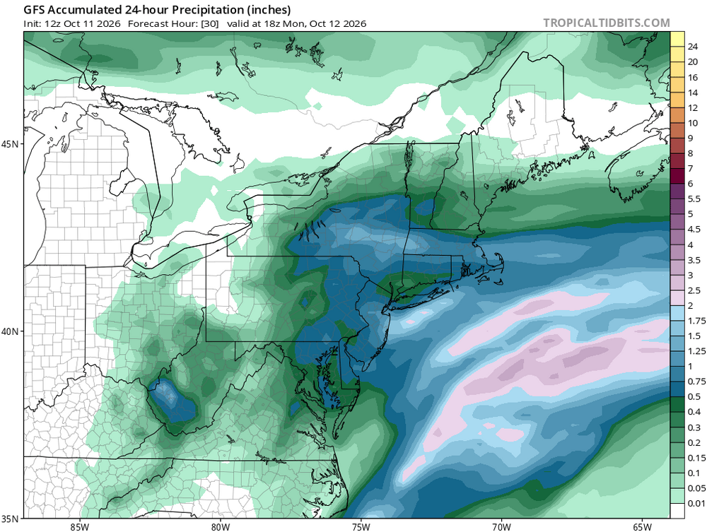
This is what the 12z Gfs drops after 2pm today.
-
1.6” here in Linglestown so far, 55 degrees, 2nd cup of coffee.. I love October.. .
-
He seems to strikeout as often as the white sox do..lol
-

October 2026 General Discussion
michsnowfreak replied to SchaumburgStormer's topic in Lakes/Ohio Valley
Marquette set a record high of 81° yesterday. Detroit was "only" 71°. -
Somebody was just saying Thursday I think, that there were no troughs, and cool weather in sight, due to the western Pac typhoons not recurving lol.
-
2.78”, becoming more drizzly and showery
-

2026-2027 Record-breaking El Nino
40/70 Benchmark replied to Stormchaserchuck1's topic in Weather Forecasting and Discussion
Ignore this at your own forecast peril if you plan on publishing work touting a non-winter along the east coast. The final two analogs have very similar placement of the central-based connective node this season, which is in the vicinity of 170 degrees longitude in the central Pacific, however, they were appreciably weaker El Niño events that were largely bereft of any eastern competition. The forcing was in the central Pacific simply because they were central-Pacific El Niño events, which is why there was no competing forces stretching the convection, as is the case this year. Thus it is for this reason in addition to the warming climate that the second half of the impending winter is highly unlikely to be as consistently cold as the coming season, despite each being viable polar analogs. It is for these reasons that this season the warmer periods will be of longer duration and of greater magnitude than the colder periods relative the 1957-1958 and 1965-1966 analogs. However, each of these seasons are relatively strong polar analogs and the center of the convective forcing was nearly identical to where the central node is expected to reside during the coming season, at around 170 degrees longitude. -
Places out west like SLC have been getting consistent stretched of +10 for weeks at a time. I pointed it out a couple of summers ago. Normal high was 88F and they were clocking 100F on 14 day forecasts. Its bone dry out there, so if they get stuck in an airmass, there is no moisture in the air to slow down the endless skyrocket each day
-
Not @CoastalWx. He would be "tea-kettle" STEAMED if that happened b/c it wasn't within 5 mi of Weymouth! GFS not by itself here. It's a quite impressive cold trough for mid-Oct, and fits the very strong El Nino pattern well. The only decent CONUS cold shots in such winters occur in the NEUS.
-
Very healthy event here this morning. It’s funny bc we all talked about needing tropical remnants here and finally got it. Also…weekend rule is still a thing.
-
2026-2027 Record-breaking El Nino
40/70 Benchmark replied to Stormchaserchuck1's topic in Weather Forecasting and Discussion
Adam used to edit previous posts to add in another comment lol...I like that better. -
2026-2027 Record-breaking El Nino
40/70 Benchmark replied to Stormchaserchuck1's topic in Weather Forecasting and Discussion
Right....not as far west as 2023, which as into the MC and very hostile. Expect it to the south of Hawaii...this is more favorable. This is what I was just trying to explain to Chuck. -
Also TOG over Fayetteville Severe Weather Statement National Weather Service Raleigh NC 1204 PM EDT Sun Oct 11 2026 NCC051-111615- /O.COR.KRAH.TO.W.0013.000000T0000Z-261011T1615Z/ Cumberland NC- 1204 PM EDT Sun Oct 11 2026 ...A TORNADO WARNING REMAINS IN EFFECT UNTIL 1215 PM EDT FOR NORTHWESTERN CUMBERLAND COUNTY... At 1203 PM EDT, a confirmed tornado was located over Fayetteville, moving northeast at 35 mph. HAZARD...Damaging tornado. SOURCE...Radar confirmed tornado. IMPACT...Flying debris will be dangerous to those caught without shelter. Mobile homes will be damaged or destroyed. Damage to roofs, windows, and vehicles will occur. Tree damage is likely. This tornado will be near... Fayetteville around 1210 PM EDT. Other locations impacted by this tornadic thunderstorm include Bonnie Doone. PRECAUTIONARY/PREPAREDNESS ACTIONS... To repeat, a tornado is on the ground. TAKE COVER NOW! Move to a basement or an interior room on the lowest floor of a sturdy building. Avoid windows. If you are outdoors, in a mobile home, or in a vehicle, move to the closest substantial shelter and protect yourself from flying debris.
-
2026-2027 Record-breaking El Nino
40/70 Benchmark replied to Stormchaserchuck1's topic in Weather Forecasting and Discussion
I'm not talking about STRENGTH...I mean strongest point of convective forcing. -
MAJOR CC drop now