All Activity
- Past hour
-

The “I bring the mojo” Jan 30-Feb 1 potential winter storm
SnowDawg replied to lilj4425's topic in Southeastern States
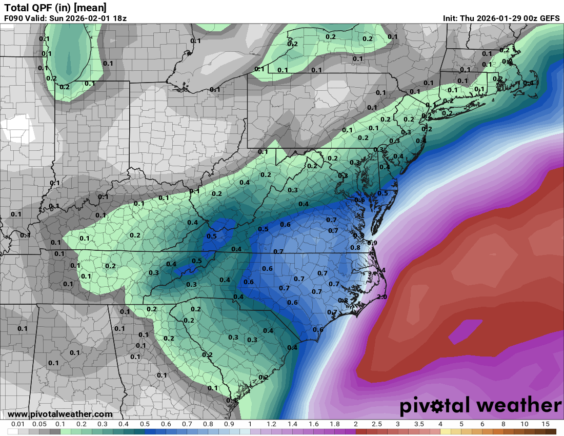
Every model but the GFS and NAM are starting to look really solid for Ne GA and the upstate. I'd still take the GFS solution too but it's way too close for comfort. -
 If these numbers are close this would be a huge hit for everyone. 15to 1 in Central NC, 25 to 1 in SWVA and NWNC
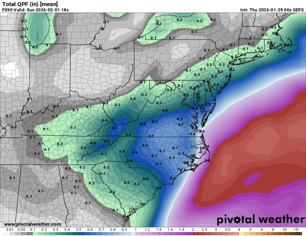
-
I will be able to smell the snow, lol
-

February 2026 Medium/ Long Range Discussion: Buckle Up!
Ji replied to Weather Will's topic in Mid Atlantic
Been watching that … don’t know how to beef it up -
We disregard the UKMet model here too.
-

Let’s talk winter!! Ohio and surrounding states!! 24'-25'
TheClimateChanger replied to buckeye's topic in Lakes/Ohio Valley
With this most recent storm, Columbus has now recorded more snow through today's date than every winter since 1996, except for 2014! We literally may never see another winter like this in our lifetime. Note rankings below are for the airport site only. -

February 2026 Medium/ Long Range Discussion: Buckle Up!
Bob Chill replied to Weather Will's topic in Mid Atlantic
Under 7 days away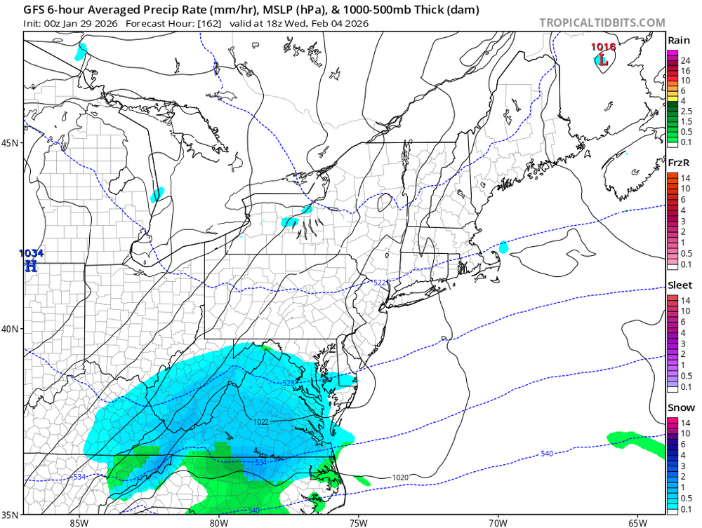
-
Watertown has been getting destroyed all frackin DAY! Check out different times on the vid! Man that LES fell HARD at times!
-
Gefs better
.thumb.png.cd99cb77cad9d0ae3868d9d6012829d8.png)
-

The “I bring the mojo” Jan 30-Feb 1 potential winter storm
ADB83 replied to lilj4425's topic in Southeastern States
UK, last global insisting on a virtual miss, throws in the towel. Beautiful . -
Gefs snowier
.thumb.png.58c042cdb262d30d6ee223a6f5030268.png)
-

Possible coastal storm centered on Feb 1 2026.
WinterWolf replied to Typhoon Tip's topic in New England
It’s gonna cave after it’s one rebound imo. But I don’t know if it’s time to bail yet. Gotta wait till the sampling is complete imo…then we move on if things don’t improve. -

The Jan 31 Potential: Stormtracker Failure or 'Tracker Trouncing
SnowGolfBro replied to stormtracker's topic in Mid Atlantic
Germans - Pearl Harbor - Bluto -
I’m giving it til 12z
-

Possible coastal storm centered on Feb 1 2026.
Wxbear25 replied to Typhoon Tip's topic in New England
The energy that eventually becomes our storm is still over far-northern Ontario, which I cant imagine is great for data collection. Remember the last system, how over time the northern stream sourced from the same region ended up stretching more and more as we got closer to the event? I wouldnt be surprised if we see that occur here as well. That should be over the northern U.S. around 12z Friday, so personally im going to give it until then, even if we should have more info by 00z Thursday night -
yeah I recall 94 - we were about -10 to -15F in Staunton. We were driving to Baltimore - the entire drive the temp never got above 0. The Inner Harbor was frozen over completely
-

The “I bring the mojo” Jan 30-Feb 1 potential winter storm
BornAgain13 replied to lilj4425's topic in Southeastern States
Very minor tick west on GEFS Snowmap but overall virtually unchanged from 12z -

The “I bring the mojo” Jan 30-Feb 1 potential winter storm
HKY_WX replied to lilj4425's topic in Southeastern States
18z EPS SLP plots. Some good agreement on a track about 50 to 75 miles off HAT. Pretty good track for central and eastern NC.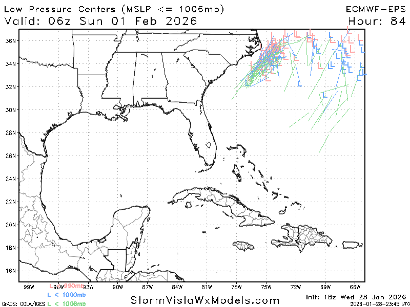
-

The “I bring the mojo” Jan 30-Feb 1 potential winter storm
JoshM replied to lilj4425's topic in Southeastern States
I don’t even look at those. I just take the QPF number and multiply it by 15 -
Crazy uncle needs a straight jacket. That is some wild stuff that would set records. If it's going to be a complete miss, please let it verify. One for the ages.
-
The 18z ECM was the only model for the past several days to depict the weenie mid-level fronto band displaced very far northwest of the SLP that sometimes materializes in these wrapped up ULLs. The 18z run really wrings it out in western SNE - would probably be 10" of powder back to Springfield and Hartford on that depiction. But it even affects the NYC area for several hours. We need to see the ribbon of vorticity out ahead of the ULL punch further NW into Canada to allow the cutoff more room to curl up underneath. That allows the mid-level goods to retrograde further west. Odds are against us based on minimal support even amongst ensembles. But I'll be watching that key band of vorticity as we enter the hail mary range.
-

The Jan 31 Potential: Stormtracker Failure or 'Tracker Trouncing
psuhoffman replied to stormtracker's topic in Mid Atlantic
WHen we are this close now... having the furthest east model come in line with consensus is not an "improvement" if the consensus is a miss. That is simply guidance converging on the solution...but in this case that solution is a miss. When a full run of guidance is over...average everything together...and if the average of all the guidance (and you should weight it, the euro gets more weight than the GFS in this math) but if the mean of the whole suite of runs didn't move closer...it wasn't an improvement just because one or two of the worst solutions got marginally better. -

The “I bring the mojo” Jan 30-Feb 1 potential winter storm
lilj4425 replied to lilj4425's topic in Southeastern States
Is the Ukie only using 10:1 ratios? Is that the way it works with all of these models when they spit out the snow numbers? -

The “I bring the mojo” Jan 30-Feb 1 potential winter storm
NC_hailstorm replied to lilj4425's topic in Southeastern States
UK goes neutral at 66,negative tilt at 72.Big hit.


.png.a4629320122fa351eae8cd20cb1cb520.png)
.png.2a52f66959bca96ec7f2dc155fbc8a29.png)


