All Activity
- Past hour
-
which was what storm?
-
In fairness I wouldn't lose sleep over this 1-3 inch snowstorm missing to the south if that happens. Now, if we get a December 2018 then its worth it.
-
I’ve never seen any MJO history prior to the BoM’s 6/1/1974.
-
FWIW the 12z CMC seems to have more interaction with the low I was talking about earlier and its to the shortwaves seeming determent as its unable to turn more neutral to negative as both runs fail to ingest the vorticity but 12z gets more interaction without phasing. Maybe there's a minimum in potential between either no interaction outwest and relying on just the NS diving and the other potential of a relatively complete and clean phase (which would have a higher upside) 12z last 12z
-

December 2025 regional war/obs/disco thread
Torch Tiger replied to Torch Tiger's topic in New England
and miss your inner-fighting and melts? -
Thank you so much. For a long time I had been trying to figure out when it was that I had about a 3 footer and thanks to your work I was able to figure it out even though the map for the event only shows 2 feet.
-
write a letter, make sure they know
-
TLDR: Yes, that's what I would do. To my knowledge, but with low confidence, there is still the "greatest depth in 24 hours" thing. There's so much noise and conflicting guidance on the web, including between different NWS pages, that its near impossible for us mortals to be definitive. Plus, there's different standards for airports/ASOS sites and other users. Not sure if COCORAHS, coops, mesonets, and spotters get the same guidance either. And then there's the measure only at set times sites (cue cpcantmeasuresnow). It's mayhem. I've gone back to resetting at phase changes or between unusual events like separate snowfalls in the morning and evening. Just seems like common sense to me. Otherwise, I do wipe the board at midnight (once per day). I'm amenable to updating my methodology if someone can convincingly show that I'm not doing it correctly.
-
If you take a step back and just look at the larger pattern progression it might be the period that makes the most sense...but it's also the furthest out of all the concrete threats.
-

2025-2026 New England Snow Recordkeeping Thread
tunafish replied to bristolri_wx's topic in New England
I'm half joking. Most likely @bristolri_wx didn't set me up with editor permissions. -

December 2025 Short/Medium Range Forecast Thread
nrgjeff replied to John1122's topic in Tennessee Valley
Ope! Two more posts came in while I was deliberating. RAP looks juicier. Otherwise my sports malaise creeps into weather... Thursday night looks similar to Monday night. Little bit of ice (trace) northwest of I-40 in the Mid-South. Light snow north of that, but probably less for northern Kentucky. Any light mix or ice area will get slick roads. Not enough QPF to mess with trees and power lines. Let's keep those themes all winter! Wake me up with Chattanooga can get below 40 deg during precip. January? Ah hell, let me get back into the severe thread and chew on Jag's post. That's what I'm talkin' about! -
11th-12th time period... I believe a few people on here have mentioned that time period as a potential threat
-
I haven't looked at the upper level progression yet today so I was going off of yesterday (which may have had that low more important who knows). I was treating the situation as if we can get more energy together earlier we have a better shot at running the gamut of confluence to our North (I am also 100 miles south so I care a little less about the confluence). That said, I definitely see overall how changing the NS wave would help us out more concretely than anything else as it is the direct inhibitor to strengthening.
-
What I will say is that I decided to let my "slightly above average snowfall" seasonal forecast ride. And nothing I've seen so far makes me regret that.
-

Mid to long range discussion- 2025
WinstonSalemArlington replied to wncsnow's topic in Southeastern States
-
Southern part of this forum jackpotted last winter… isnt it our turn for us from gaithersburg to pa border!? .
-
This is what I meant in my last comment about so many permutations...the CMC actually made the changes we need with the NS, but it has a weaker more disjointed southern system and has this little kicker behind it that wasn't there before or on other guidance...so it ends up with the same result. If you had that NS look from the CMC with the GFS/Euro TN valley look...it would be a snowstorm for us. But I'm not good enough to figure out all these little variables from this range and I am not going to project false confidence and pretend I am.
-
BTW: CMC has a really nice mid-20s snowstorm the 12z that brings 6 inches from the MD/PA border to south of Richmond
-
Hopefully there will be no ginxy AI vid of this
-
Past two runs have had increasing separation between the southern and northern waves. That looks like an ample route to a success scenario.

-
I’ve had those sensors never go below 33° all winter when the pack is deep enough. Where the ground is exposed it freezes deep though. I clear grassy areas for the chickens all winter and come April the cleared areas are usually about a half foot higher than the ground that was under pack because of how much it froze and heaved upward.
-
Does anyone know of anywhere that has MJO RMM plots before 1975? The Australia BOM archived site only goes back to 1975.
-
Just imagine if we could get the vort for Monday to go negatively tilted. Canadian tries to amp it up late, which is why the clown maps are better down east but a very close call to a big dog almost forum wide.
-
Starting to get some breaks in the clouds after a cold overcast morning. 36°.
-

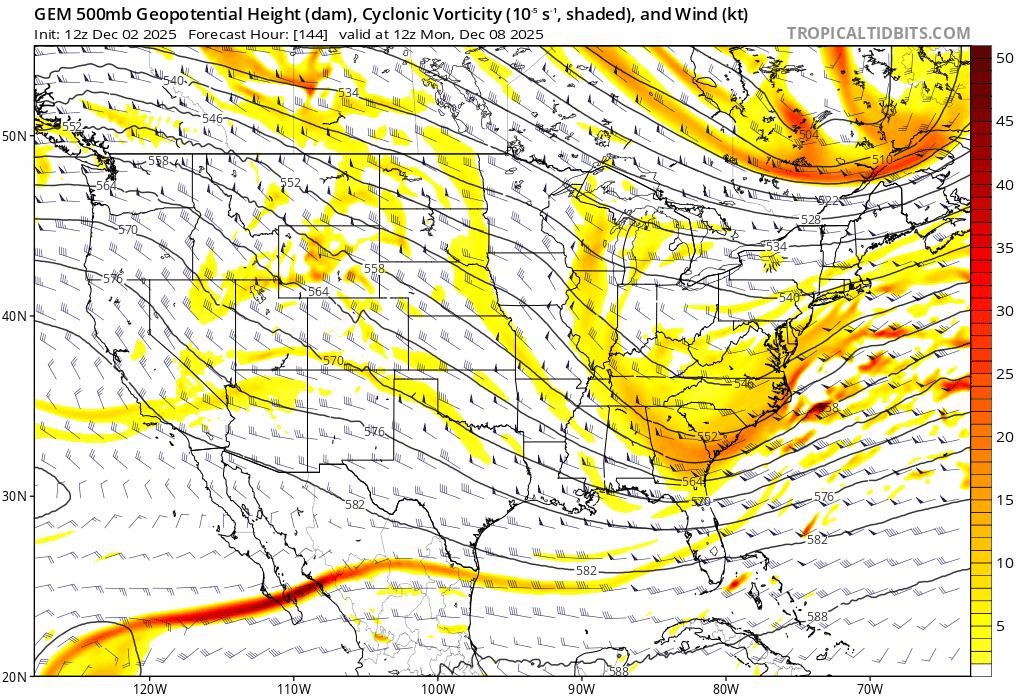
Richmond Metro/Hampton Roads Area Discussion
Ephesians2 replied to RIC Airport's topic in Mid Atlantic
Big Improvement on the Canadian for Monday
.thumb.png.6259b803be20d030cac7a37b2696f666.png)


.png.b14a690fe92d65b740a52c83b98b7e89.png)