All Activity
- Past hour
-

November 2025 general discussions and probable topic derailings ...
CoastalWx replied to Typhoon Tip's topic in New England
Meh. Cold is going to plains first. Need the PV further SE. Needs work. -
Time for a new thread altogether
-
December 2002 was a great winter for me in nj. Had snow on my birthday 12/8 then it was cold and snow stuck around most of the month till the Christmas storm, then the snows we had the following months then the big blizzard presidents day weekend.
-

November 2025 general discussions and probable topic derailings ...
Ginx snewx replied to Typhoon Tip's topic in New England
Models are missing the push of the negative EPO. Seen it many times. -
Congrats on taking number 1
-
November 2025 general discussions and probable topic derailings ...
Ginx snewx replied to Typhoon Tip's topic in New England
Omg yes yes yes. -
The main issue in recent years with MJO forecasts in general has been the record warm SSTs over the tropical WPAC into EIO stalling convection there. So even if the RMM charts show the MJO going into phase 8, the VP charts will often have convection lingering over the WPAC. Our last clean MJO 8 was back in January 2022. Recent MJO 8 passages on the RMM charts didn’t match the classic MJO VP composites. Since the RMM charts did show a phase 8 but convection lingered near the Maritime Continent. Plus another issue has been the convective forcing stalling in 6-7 before going into the circle or only a very low amplitude MJO 8. So it’s better to monitor the velocity potential charts along with the RMM charts to get a complete picture of the convective forcing.
-

November 2025 general discussions and probable topic derailings ...
WinterWolf replied to Typhoon Tip's topic in New England
It’s been a quintessential autumn in SNE…just what it should be. -

Central PA Fall Discussions and Obs
Jns2183 replied to ChescoWx's topic in Upstate New York/Pennsylvania
I see nothing beneficial in long term. I do see a chance for showers the entire work week Sent from my SM-X210 using Tapatalk -
Yeah, its been spitting flakes off and on over the past hour in this neck of the woods.
-
DT warned yesterday that the MJO push into phase 8 is looking like it’s going to be delayed…
-
IF (If) the GEFS, EPS and GEPS are correct in how far west the ridge is going to set up (Bering Sea/Aleutians) in the long range, then yep, they are underestimating the SE ridge
-
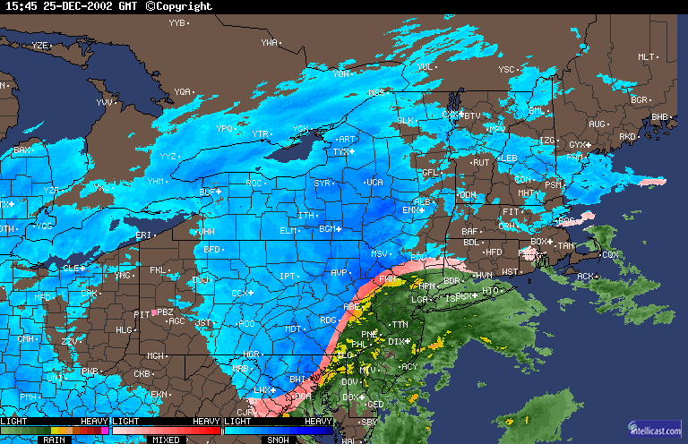
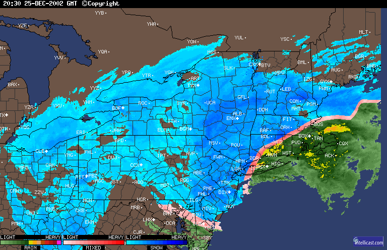
7 to 10 inches here, completely unexpected. Thundersnow by LGA around 4 to 5PM. My car managed to get parked in front of my then girlfriend's house for her parents' Christmas party and there it stayed overnight lol It was a rear wheel drive stick shift with low profile performance tires. Basically the worst combination for driving in heavy, pasty snow.
-

November 2025 general discussions and probable topic derailings ...
GCWarrior replied to Typhoon Tip's topic in New England
Deep winter feel out here in the Berkshires! -

2025-2026 ENSO
brooklynwx99 replied to 40/70 Benchmark's topic in Weather Forecasting and Discussion
I’m pretty sure the GEFS has a strong/cold bias with the SPV, but i could be wrong -
Interesting they were all working for me…
-

Central PA Fall Discussions and Obs
mahantango#1 replied to ChescoWx's topic in Upstate New York/Pennsylvania
Wonder when we're gonna get some benifical rain? My total for the month so far is only .26 -

November 2025 general discussions and probable topic derailings ...
Layman replied to Typhoon Tip's topic in New England
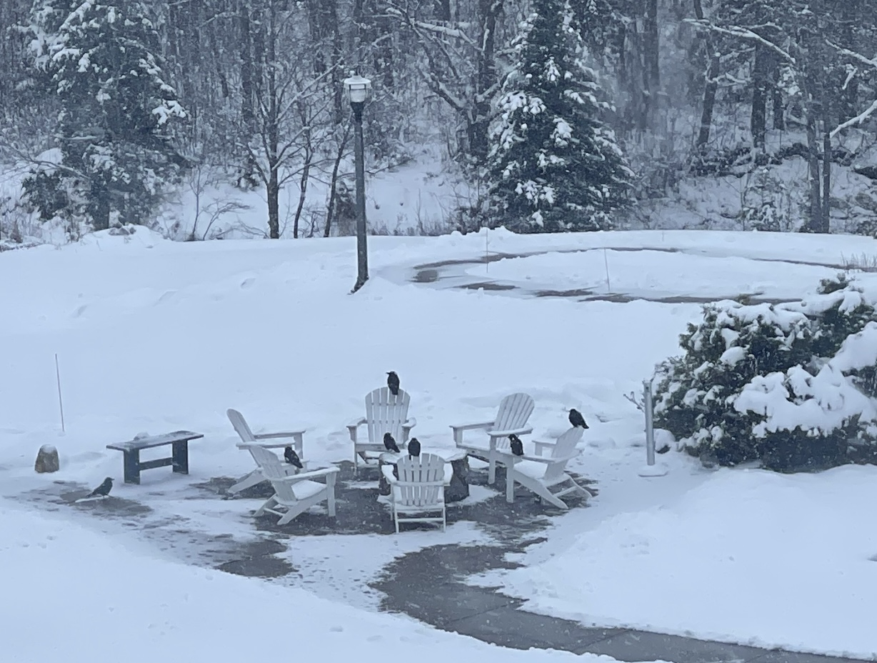
Still snowing nicely up north. The crows seem to have formed a committee to hash out the details of the pending warmup.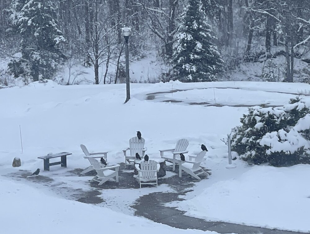
-

Fall 2025 Medium/Long Range Discussion
ChiTownSnow replied to Chicago Storm's topic in Lakes/Ohio Valley
That somehow did not turn out to be a clown -
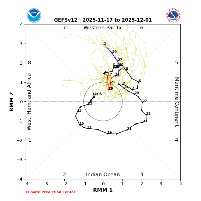
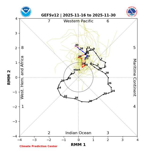
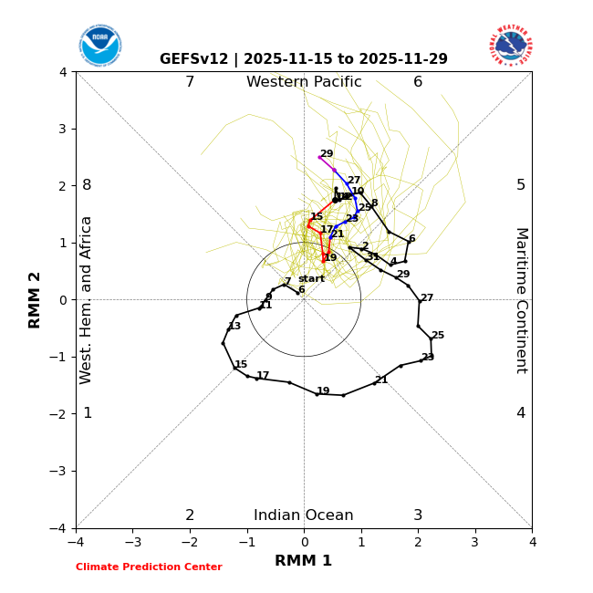
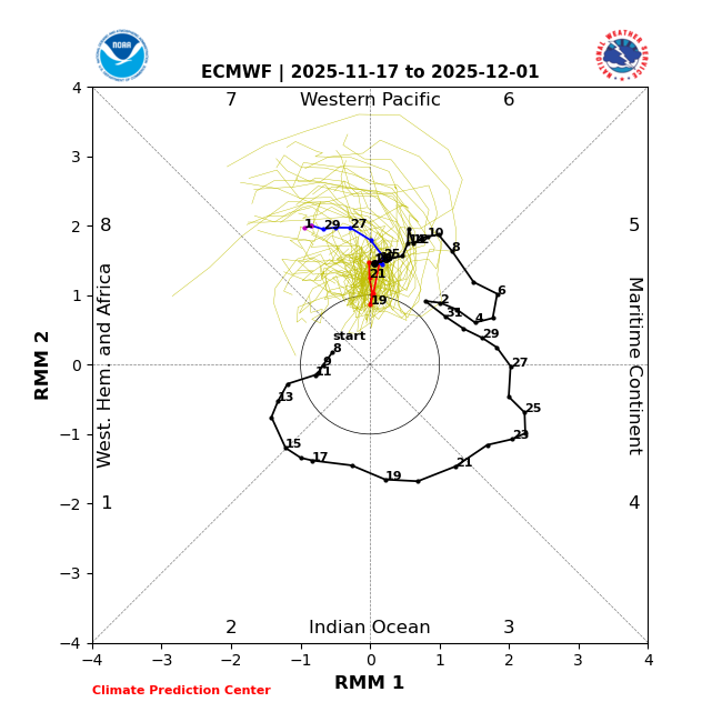
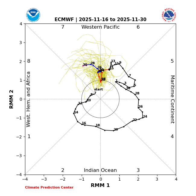
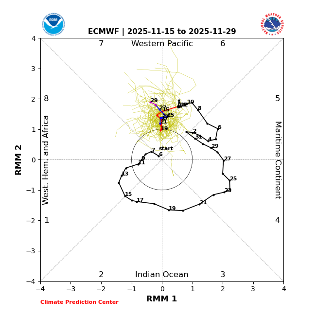
11/17/25 MJO forecasts is mixed bag: 1) 11/17/25 GEFS backtracked to ~2 days slower than yesterday’s slightly more progressive/weaker run to being nearly identical to the more lethargic and stronger run of 11/15 (not what I wanted to see): GEFS 11/17: stronger/less progressive vs GEFS 11/16 and close to GEFS 11/15 GEFS 11/16: was slightly more progressive/weaker than GEFS 11/15 GEFS 11/15: ————— 2) However, 11/17/25 EPS remains similar to yesterday’s slightly more progressive run and continues to be a good bit more progressive/weaker than GEFS, two things I like: 11/17 EPS: similar to 11/16 EPS and more progressive/weaker than 11/17 GEFS 11/16 EPS: slightly more progressive than 11/15 EPS 11/15 EPS:
-
Good ol Nina
-
One of the rare times backside snow worked out around here. Had about 8-9 inches of cement from that one here...
-
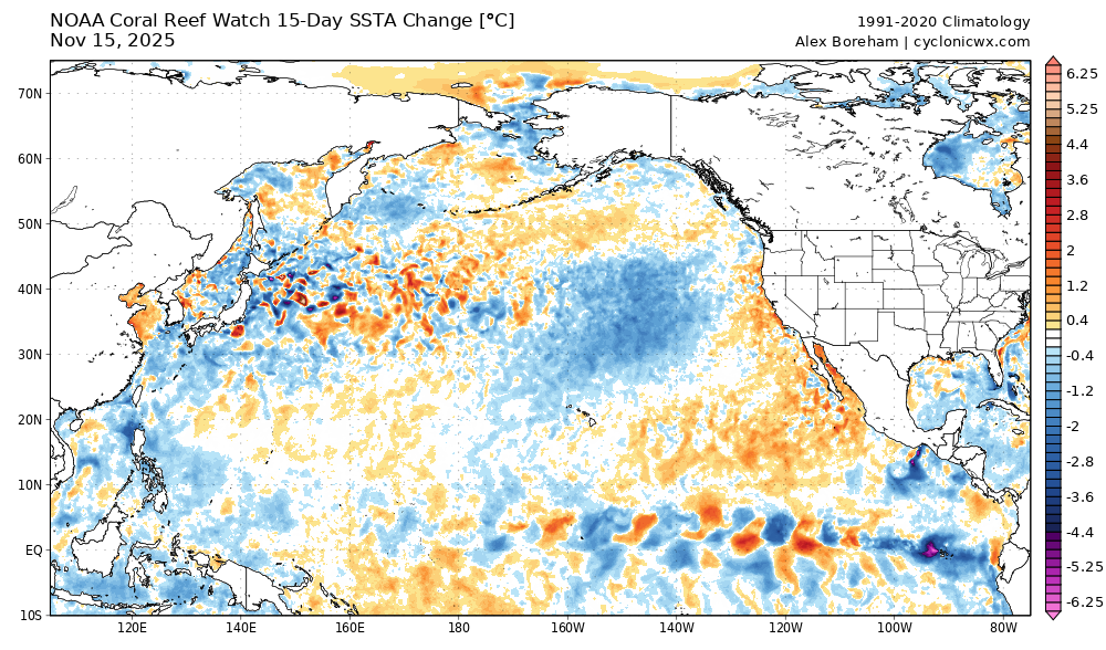
15 day change
-
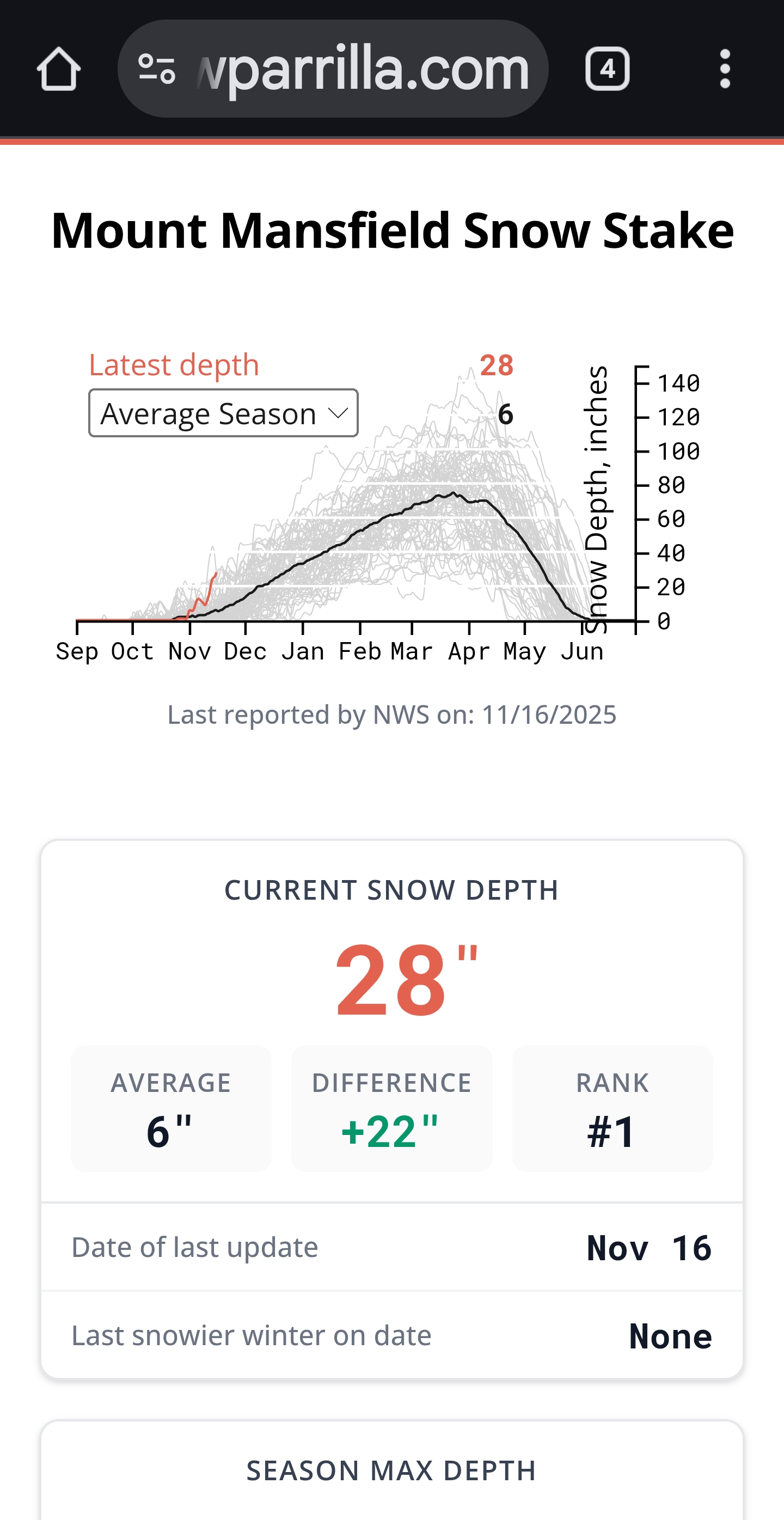
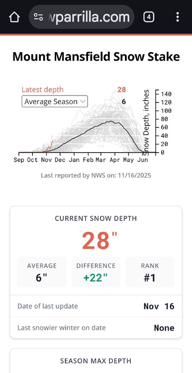
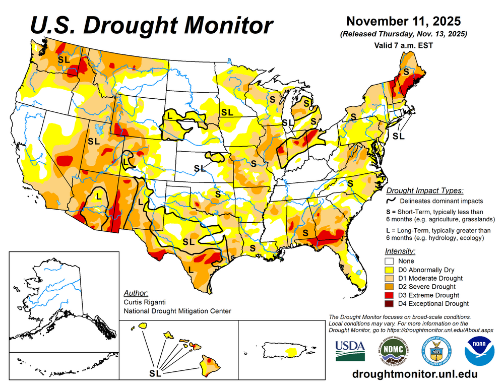
#1 for this date all time and with lots more on the way, not even close… .
-
That was really my only time in Long Beach when a .50 of rain with thunder and low 40s ever transitioned into greater than a 6” snowstorm.