All Activity
- Past hour
-

Winter 2025-26 Medium/Long Range Discussion
dmc76 replied to michsnowfreak's topic in Lakes/Ohio Valley
0.7”-1.3” dusters are back !!! -

Central PA Winter 25/26 Discussion and Obs
pasnownut replied to MAG5035's topic in Upstate New York/Pennsylvania
wasnt that the case for our late Jan snowbonanza? me thinks Euro played catch up. GFS was sniffin early -

Winter 2025-26 Medium/Long Range Discussion
michsnowfreak replied to michsnowfreak's topic in Lakes/Ohio Valley
Sunday has piqued my interest for now. -

“Cory’s in NYC! Let’s HECS!” Feb. 22-24 Disco
Sey-Mour Snow replied to TheSnowman's topic in New England
Sorry for your loss.. 44-48 around here bright sunshine.. -
They don't need any more storms, they always seem to get good storms.
-
This storm has much higher heights ahead of it than last February's fish storm or this February's fish storm. Its going to be much harder to suppress.
-
Central PA Winter 25/26 Discussion and Obs
pasnownut replied to MAG5035's topic in Upstate New York/Pennsylvania
After the morning I've had, if I can....you can. suckitupbuttercup -

E PA/NJ/DE Winter 2025-26 Obs/Discussion
Ralph Wiggum replied to LVblizzard's topic in Philadelphia Region
GEFS went east. This is the fail scenario that most concers me and fits seasonal pattern. -

“Cory’s in NYC! Let’s HECS!” Feb. 22-24 Disco
Damage In Tolland replied to TheSnowman's topic in New England
36 here . Torch !! -
Central PA Winter 25/26 Discussion and Obs
pasnownut replied to MAG5035's topic in Upstate New York/Pennsylvania
this is what I want to see.... On monday morning. Till then...just perty colors IMBY -
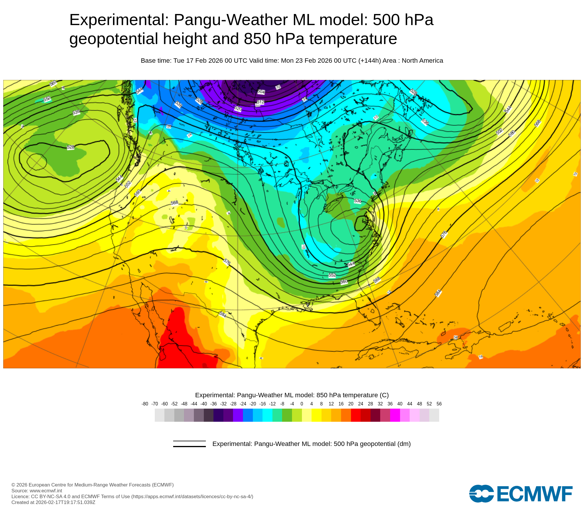
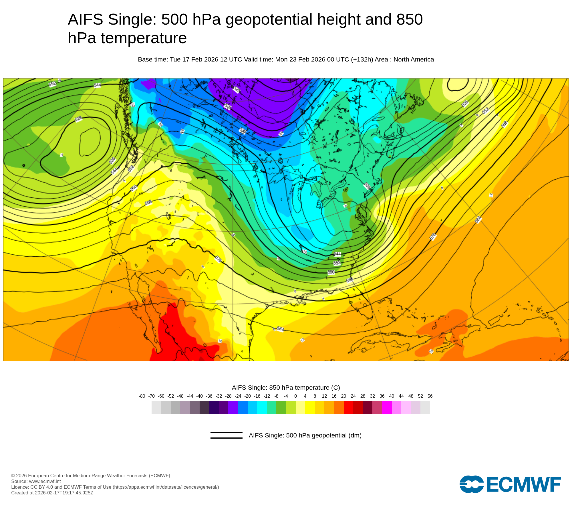
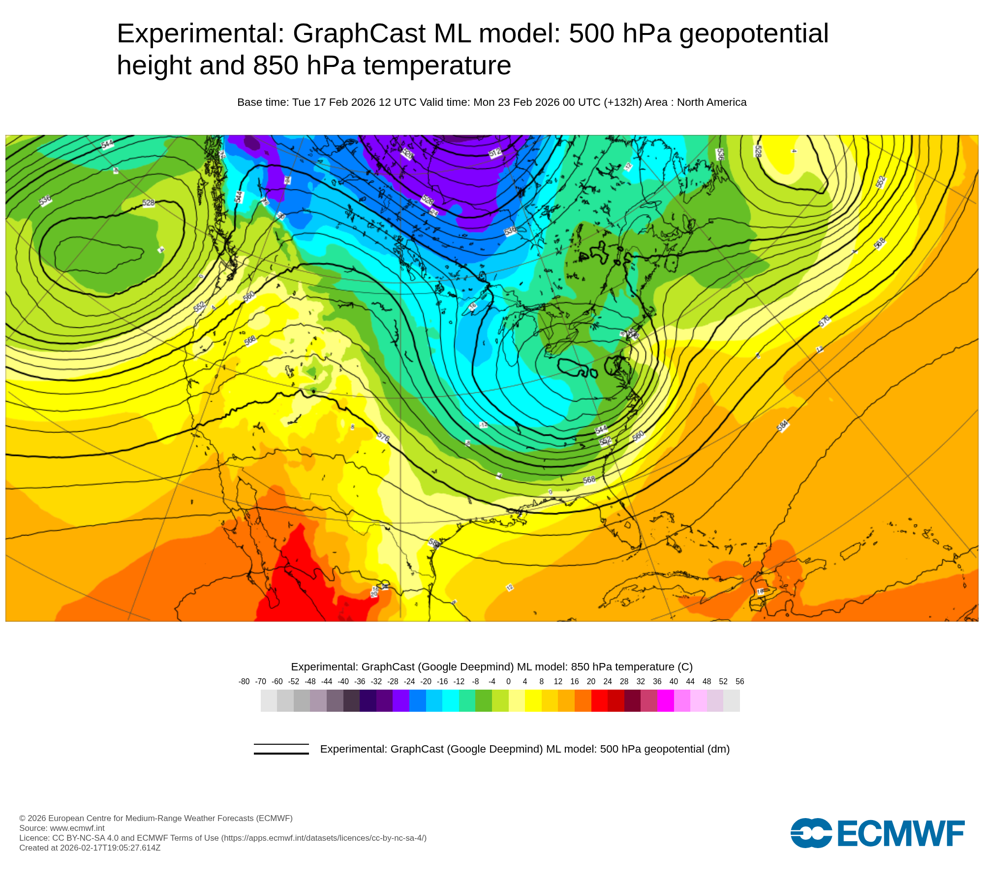
Basically agree with Brooklynwx. From past experience given the run to run consistency and cross-model agreement amongst the various ML models including AIFS and its ensemble, WeatherNext, GraphCast and Pangu, I would expect the EPS to shift closer to their scenario in the next 24-36 hours.
-
Central PA Winter 25/26 Discussion and Obs
pasnownut replied to MAG5035's topic in Upstate New York/Pennsylvania
like you/others stated, long way to go here, and while the nooners look good, still a long way to go here, and as antecedent cold is not stoudt, yeah, nails gonna b bitten down here (assuming GFS has a clue....) -
“Cory’s in NYC! Let’s HECS!” Feb. 22-24 Disco
Sey-Mour Snow replied to TheSnowman's topic in New England
lmao I've been posting more about torch and warm days just to get the ACATT riled up -

E PA/NJ/DE Winter 2025-26 Obs/Discussion
Duca892 replied to LVblizzard's topic in Philadelphia Region
Certainly not suggesting he is right (I am FKN moron, what do I know?) but his reasoning of why no storm has been backed up by the EURO at the moment. Just contributing others thoughts is all. -
It is encouraging to see two other highly skilled ML models (GraphCast and Pangu) show an outcome very similar to the AIFS and also similar to AIFS ensemble mean, without the entanglement of the the Sun-Mon system with the system ahead of it across SE Canada shown by the operational ECMWF (last image).
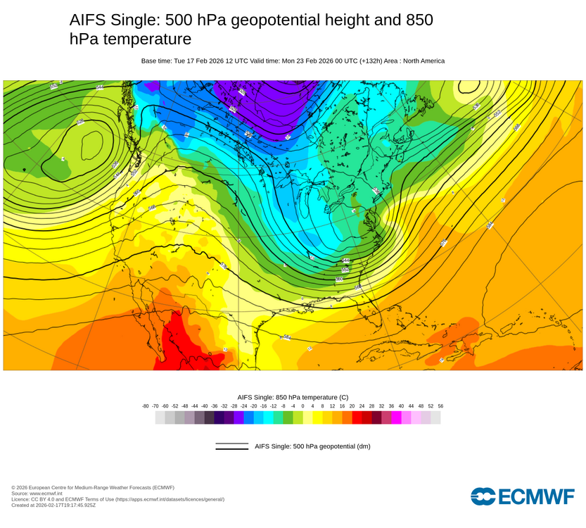
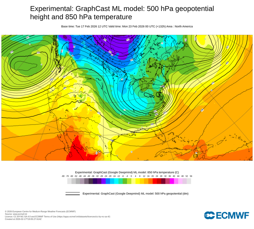
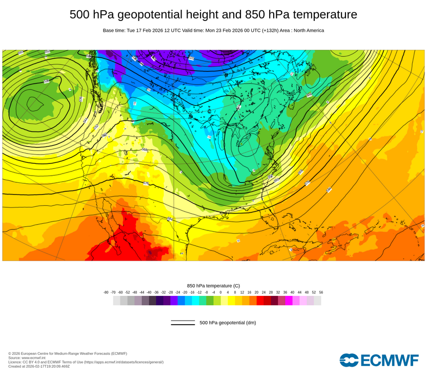
-
Central PA Winter 25/26 Discussion and Obs
pasnownut replied to MAG5035's topic in Upstate New York/Pennsylvania
40/70 is lat/lon for "benchmark" for classic noreasters/snowstorm signal. Verbatim map you shared was 200miles wsw of that location. That is called "tucked". Since you new, take notes....too old to have to repeat myself -

E PA/NJ/DE Winter 2025-26 Obs/Discussion
RedSky replied to LVblizzard's topic in Philadelphia Region
Still 5 days away which is a guidance eternity these days -
Central PA Winter 25/26 Discussion and Obs
pasnownut replied to MAG5035's topic in Upstate New York/Pennsylvania
benchmark is 40/70 lat/lon. this is notably W by about 200 miles thats a legit worry for you and I -

-
 What was the intensity at landfall?
 -

“Cory’s in NYC! Let’s HECS!” Feb. 22-24 Disco
TheSnowman replied to TheSnowman's topic in New England
Our Shakespeare Weather Friend Typhoon Tip: PRO: EPS mean being more aggressive than the operational version at this range is typically a red flag .. CON: however, to the straw man, having the ens mean more impressive than operational was also prevalent at this sort of range prior to the end January phantom bomb too. It didn't end well for the ensembles. Particularly in the EPS back then. CON: If it were not for the -PNA canvas I'd have less issue with this has value. PRO: The 00z CMC ensembles being hugely more bullish than the prior 12z mean is. PRO: While the 00z GEFs were still not very interested, the 06z made a significant step toward more concern. I don't think that's a trivial or unimportant. PRO: Sneaky aspect about the pattern foot ... the flow is both progressive, while relaxed in gradient. Of the two, the latter is a bigger positive than the former takes away. It's interesting ( actually ) to see that concurrent physical state in the field, but there is in fact less 60N to 35 N ambient gradient, which allows for more timely/delicate wave harmonics to get set up. This whole system seems to be nested in that favorable temporal dimension ... any later in date or early, it doesn't avail of that and ends up probably sheared/stretched and annoying. CON: Seasonal dearth of coastal storm types. This doesn't intrinsically instruct this thing for or against occurring, but the consistent no-gos do suggest something's going on that is preventative - identifying what that is, and if it is less effective in this case would be interesting. Lastly ... kind of a PRO. The hemispheric PV is either explicitly anchored, or implicitly attempting to do so, depending on guidance sourced and cycle/run, on our side of the NH. This is also somewhat sneaky and unnoticed, but it matters because if it were situated over on the other side while a very robust -PNA ... ongoing, we probably don't have any of this in the first place. 50/50... We could certainly see a strong system miss, or impact. -
This is from this afternoons Upton AFD: AFD from KOKX
-
Lot of spread on the 12z EPS for this one, Looks a bit SE too.
-

Late February/Early March 2026 Mid-Long Range
SomeguyfromTakomaPark replied to WxUSAF's topic in Mid Atlantic
The least ai can do for us accurately depict a miller b at 5 day lead before it eventually enslaves us and turns us into batteries. -
It sure has the basics you want to see. Ridge over the intermountain west, perhaps a tad too far east but noise at this stage of the game. A 50/50 low. A northern branch s/w digging through the Ohio Valley with an already slightly negative tilt. Agree, at this point I'll take it and let the chips fall where they may. This is 5-6 days out and very far from a done deal either for a hit of some kind or a total miss. Most that can be said at this point is "moderate to strong storm signal for later in the weekend".