All Activity
- Past hour
-

Spooky Season (October Disco Thread)
UnitedWx replied to Prismshine Productions's topic in New England
Cleaned and serviced ours last weekend, and ran it for an hour this A.M. 36 degrees in Westfield this morning -

Spooky Season (October Disco Thread)
BrianW replied to Prismshine Productions's topic in New England
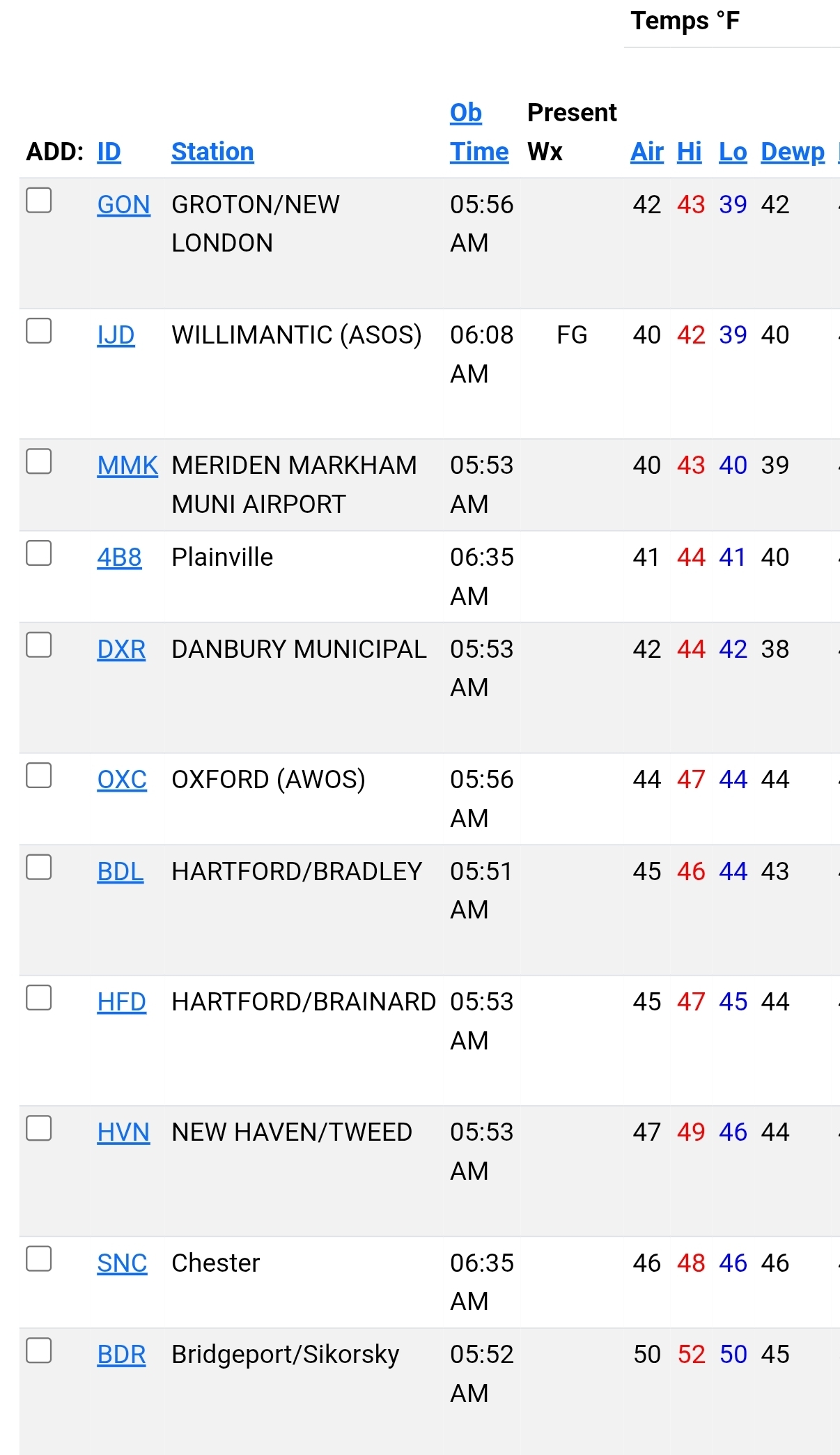
Looks like GON and IJD with the first 30s for CT. 50 for the low here.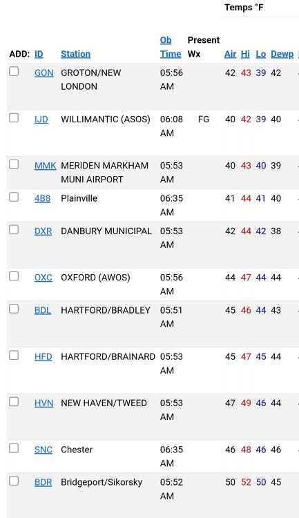
-
Bluewave has posted about how a very cold Siberia creates a contrast with the very warm water off Japan which fuels the raging Pacific jet which we certainly DON’T want. So it’s a more complex relationship than “Siberian snow cover is always good”.
-

Spooky Season (October Disco Thread)
Baroclinic Zone replied to Prismshine Productions's topic in New England
1st 30s since mid may -
Unfortunately, the later research has suggested that a higher Siberian Snow Advance Index (SAI) is correlated with a positive AO. The research notes that the early inverse relationship found by Cohen et al., was an exception, not a rule. Excerpts: The running decadal correlations between the SAI_OCT and AO and SAI_NOV and AO are shown in Fig. 7d and e, respectively. In the former, there are significantly more positive than negative values (Table 3), suggesting that the period of strong positive (negative as defined here) correlations that occurred in the 1990s and 2000s, as described by Cohen and Jones (2011), was a rather exceptional event, as previously noted by Peings et al. (2013). Indeed, the frequency of decades with significant SCA_OCT–AO correlations of either sign are not significant. In addition to the recent period in the 2000s, Fig. 7d reveals a period of significant negative correlations centred in the 1840s, also present in the 21-year data (Fig. S4d). Finally, the ERA5 data reveal that the recent period of the statistically significant negative relationship between SAI_OCT and the AO has ended: the most recent decades have positive r values.
-
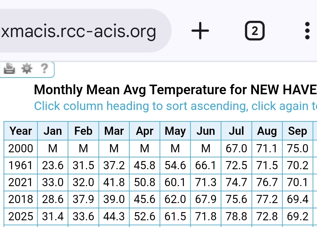
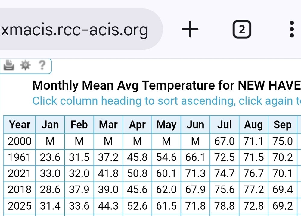
What a September down here on the sound. +3.2 for HVN. 4th warmest September on record.
.thumb.png.13aba16c7c4f11ed0ce162e236d3a24c.png)
-
Yes, but you need the snow too and you are gonna get it.
-
Yeah, we need the rain.
-
Winter is champing at the bit in the Sierra!!! Snow is falling at altitude at Mammoth Ski Resort. Looks to be 2-3 inches now on the ground and even pavements! These places have surface chillax characteristics for preconsolidation and possibly even some limited surface frigidization. Snowpack can now be seen on the ground at the Woolly Cam and also at the Main Lodge. Woolly Cam https://www.mammothmountain.com/on-the-mountain/mammoth-webcam/woolly-cam Main Lodge https://www.mammothmountain.com/on-the-mountain/mammoth-webcam/main-lodge Lights are out but reflectivity/surface albedo are way too high for that not to be at least an inch of wet snow, possibly 2-3 inches, enough for a meaningful jebwalk. Snow will continue even as temps dip to 30. Village Level is all rain, it can be seen in the puddles. That rain is at least moderate. Imagine the snow at higher elevations! Village level, steady rainfall https://www.mammothmountain.com/on-the-mountain/mammoth-webcam/the-village Palisades Tahoe has a coating to an inch at the Scope, which is now the only camera operative there. https://www.palisadestahoe.com/mountain-information/webcams#tab=palisades
-
It’s 48.4° here this morning. Dare I say it’s cold for early October
-
This -AAM regime is extremely impressive. A 180 degree difference from what we were seeing last year at this time…
-
The eastern lemon has excellent model support for development but will be another recurve
- Today
-
Have you seen the last few years of winter here? Like I said I'll take any help I can get.
-

Spooky Season (October Disco Thread)
CoastalWx replied to Prismshine Productions's topic in New England
At least there’s some signs it may turn more active mid months. Little bit of -NAO on EPS and op runs sort of showing the results of that. -
Current temp is a cold 43 degrees.
-
 __ Table of forecasts for October 2025 __ FORECASTER __________ DCA _NYC _BOS _ORD _ATL _IAH __DEN _PHX _SEA Ephesians2 ____________+4.3 _+3.8 _+3.5 _+5.4 _+4.0 _+3.6 _+1.0 _+1.3 _ -0.5 Roger Smith ___________ +3.5 _+4.0 _+4.3 _+5.2 _+3.5 _+3.5 _+2.0 _+2.0 _+1.2 StormchaserChuck1 ___ +3.2 _+3.5 _+3.5 _+5.7 _+2.9 _+2.5 _+0.5 _+0.2 __0.0 RJay ___________________ +3.0 _+3.5 _+3.5 _+5.5 _+2.0 _+2.0 _+2.0 __0.0 __0.0 DonSutherland1 ________ +2.5 _+2.6 _+2.5 _+5.4 _+1.7 _+1.7 _+3.2 _+2.6 _+0.2 wxallannj _______________+2.3 _+2.4 _+2.5 _ +2.0 _+1.8 _+2.3 _+1.0 _+0.7 _+0.4 hudsonvalley21 _________+2.1 _+2.1 _ +2.1 __ +3.2 _+1.2 _+1.8 _ +2.1 _+1.9 _+0.2 ___ Consensus _________+2.1 _+2.2 _+2.3__+3.4_+1.7 _+1.9 _+1.3 _+1.1 _+0.5 so_whats_happening __ +2.0 _+2.3 _+2.4 _ +3.5 _+1.6 _+2.1 _ +1.4 _ +1.0 _ +1.6 yoda ___________________ +1.8 _+1.4 _+1.3 __+2.5 _ +1.7 _+1.8 _ +1.3 _ +1.9 _+0.3 BKViking _______________ +1.6 _+1.7 _+1.7 __+1.7 _+1.5 _+1.2 __+1.0 _ +1.0 _ +0.8 Tom ____________________ +1.5 _+1.6 _+1.6 __+2.8 _+1.5 _+1.1 __+1.2 _ +1.1 _ +0.5 Scotty Lightning ________+1.5 _+1.0 _+1.0 __+1.0 _ +1.5 _+1.0 __+1.0 _+1.5 _+0.5 wxdude64 ______________+0.6 _+0.7 _+0.3 _-0.2 _+0.8 _+0.5__-0.4 _-0.2 _+0.7 RodneyS _______________ +0.1 _ +1.7 _+1.6 __+3.8 _+0.6 _+3.0 _+1.6 _+0.6 _+0.9 ___ Normal ______________ 0.0 __0.0 __0.0 ___0.0 __0.0 __0.0 ___0.0 __ 0.0 __ 0.0 _______________ ___ Persistence __(Sep) _-0.2 _+1.4 _+0.9 _+3.0 _+2.5 _+1.2 _-0.1 _+1.0 _+1.5 _______________ ============== warmest and coldest forecasts are color coded; Normal is colder than all forecasts for DCA, NYC, BOS, ATL and IAH. Consensus is median value of 14 forecasts (not counting Persistence which is Sep 2025 anomalies, or Normal).
 -

Spooky Season (October Disco Thread)
Snowedin replied to Prismshine Productions's topic in New England
This is essentially our winter now. With little to no moisture to trap any daytime heating, the temps plummet as soon as the sun sets. I think once our usual parade of nor’easters gets established then things will get back to “normal.” Enjoy the shrinkage while it lasts! -
Every time we have a near miss from a promising snowstorm this winter, someone is gonna post this ugly thing. It's the new Mid Atlantic Mascot.
-
This thing is gonna go viral.
-
Nice storm, GBM! Need to find a way to get this puppy to slow down and get captured! Love to see you guys end up with a wet nine feet of fresh snow!
-
Regarding the MDR lemon: A tropical wave is expected to move off the coast of Africa over the next day or two. Thereafter, this wave is forecast to interact with another disturbance in the eastern tropical Atlantic, and some slow development of the combined feature is possible as the system moves westward to west-northwestward at 15 to 20 mph. * Formation chance through 48 hours...low...near 0 percent. * Formation chance through 7 days...low...30 percent. Forecaster Jelsema ——————— I didn’t post it. But the 12Z UKMET had a TC form from this at 162 hours and it was already recurving/moving NW to 23.7N, 57.2W at 168. The new UKMET (0Z) forms it 18 hours earlier and it moves WNW instead of NW meaning it ends up much further S than the 12Z run had it at the end of the run (~150 miles NE of the Leewards): NEW TROPICAL CYCLONE FORECAST TO DEVELOP AFTER 132 HOURS FORECAST POSITION AT T+132 : 15.7N 53.2W LEAD CENTRAL MAXIMUM WIND VERIFYING TIME TIME POSITION PRESSURE (MB) SPEED (KNOTS) -------------- ---- -------- ------------- ------------- 1200UTC 08.10.2025 132 15.7N 53.2W 1009 40 0000UTC 09.10.2025 144 17.5N 56.5W 1009 39 1200UTC 09.10.2025 156 18.8N 59.3W 1009 34 0000UTC 10.10.2025 168 19.7N 61.4W 1008 31
-
This is hyperbole. Why? -DCA from 2000-01 through 2024-25 averaged 13”. Even if they were to have NO snow the next 5 winters, which of course is practically impossible since they’ve yet to have even one with 0”, they’d still average ~11” for 2001-30. -DCA averaged 10.6” 2010-11 through 2024-25. If they were to have no snow the next 15 winters (of course nothing even close to that will happen), they’d still average 5.3” for 2011-40. So, averaging <4” in Baltimore and even at DCA would be impossible not only in 2001-30 but even in 2011-40. Even for DCA to average <6” in 2011-40, they’d have to average <1.4” the next 15 winters. Only 4 of the last 141 winters (3%) had <1.4”. Yes, 3 of those have been since 1997-8, but that’s still only 3 of the last 28 or 11%. So, I see virtually no way for DCA to even get down to 6” for 2011-40. Even getting it down to 7” would require the next 15 years to average only 3.4”. That’s highly unlikely. But if that high unlikelihood were to somehow happen, we’re talking 7” at DCA for 2011-40 vs you saying 4” is possible.
-
Maybe if they would truck some of it in, it would help?
-
True. I do think ridging ends up a bit less amplified than last year, but I still think we see cold get a bit further south than what it has.
-

Spooky Season (October Disco Thread)
TauntonBlizzard2013 replied to Prismshine Productions's topic in New England
Fakersville is a magical place


.png.8a08196df65041b9f8b0d309211e366e.png)