All Activity
- Past hour
-
Man Euro was amped!


-
BWI: 21.3 DCA: 16.3 IAD: 25.3 RIC: 13.3 Tie Breaker SBY: 7.5 KOKV/MBY: 31.3
-
He said, The stats here are from a friend of my buddy Paulie, known as GaWX I think JB’s saying that his buddy is named Paulie and that I’m Paulie’s friend. But I don’t know anyone named Paulie. Maybe there’s a poster here or elsewhere who’s real name is Paulie.
-
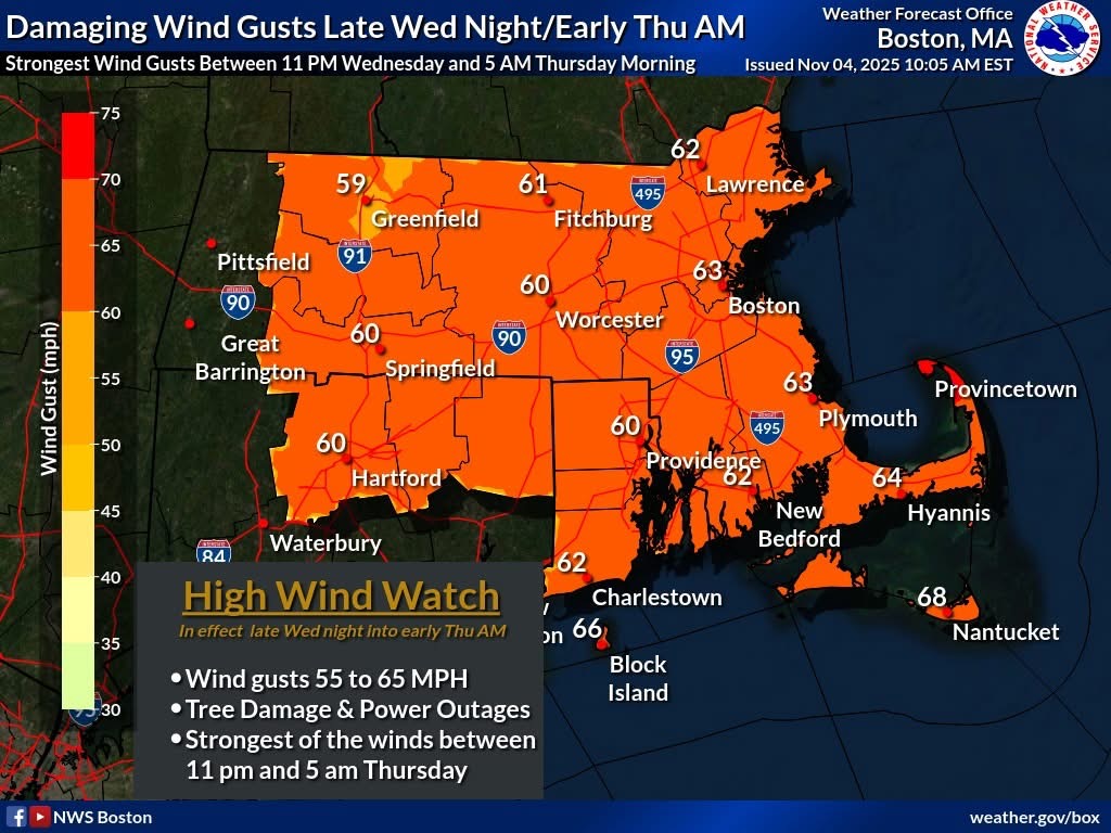
 High wind watch out for tomorrow PM for all the area
- 5 replies
-
- 1
-

-
- wind damage
- power outages
- (and 1 more)
-
-

November 2025 general discussions and probable topic derailings ...
weatherwiz replied to Typhoon Tip's topic in New England
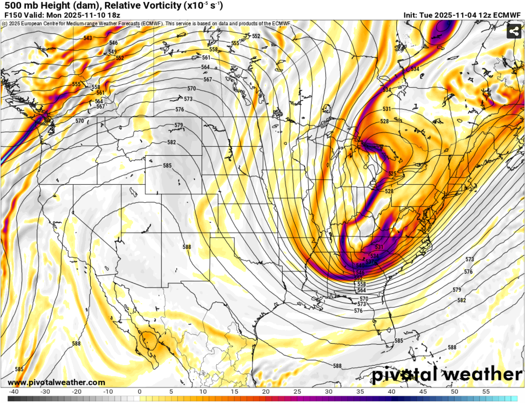
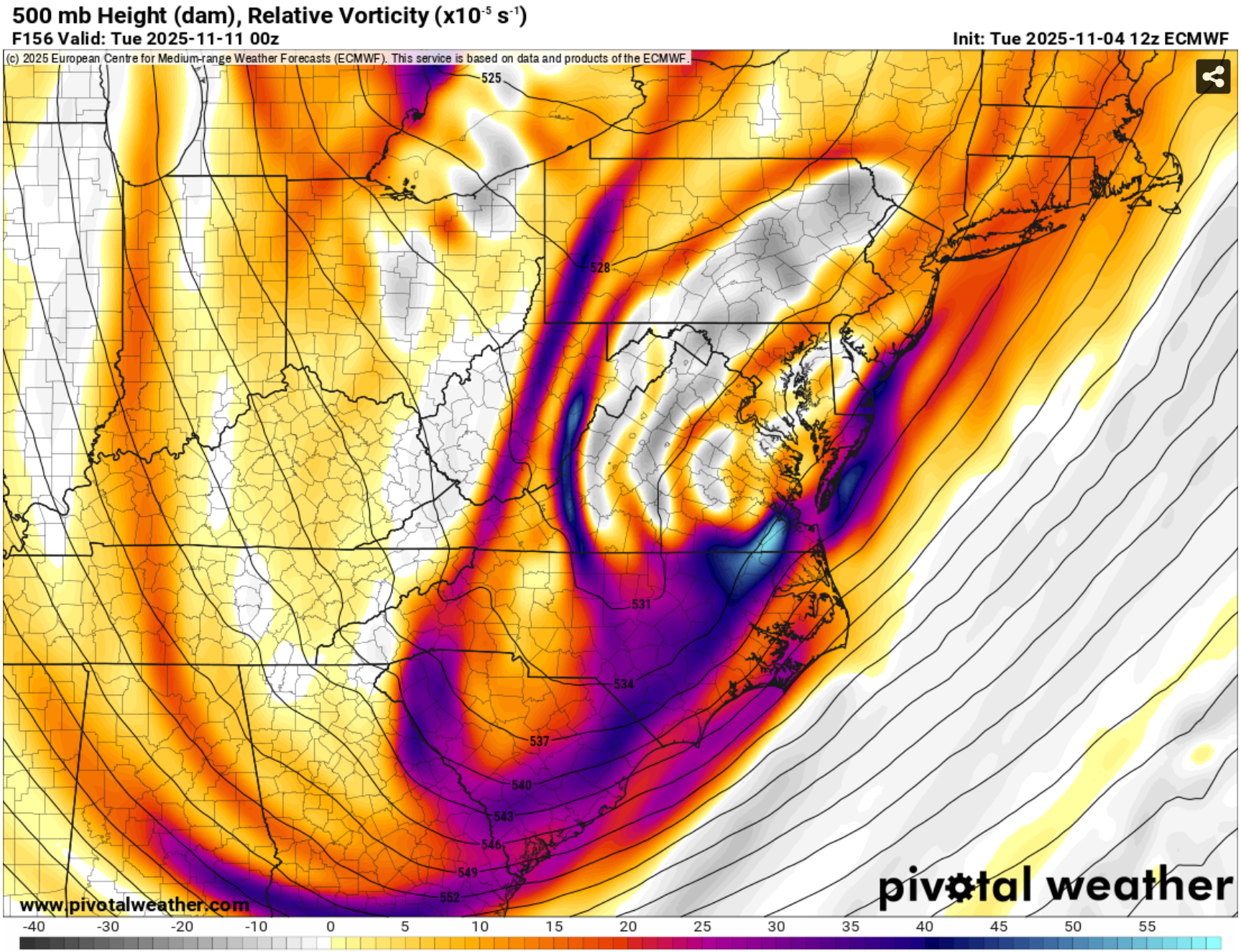
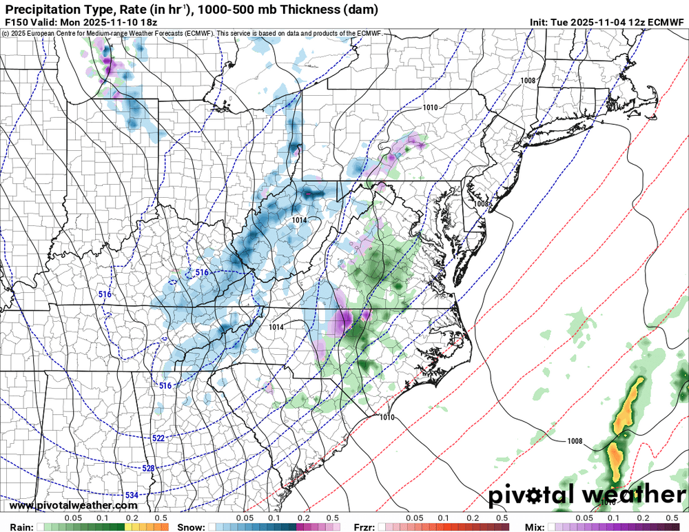
This is a different breed than what we typically see for "wind setups". Much different than those southerly wind events which always get hyped and overplayed -
A potent shortwave trough will continue amplifying as it progresses across New England characterized by a narrow 130+ knot jet streak rounding the base of the trough. Amplifying trough with diffluent upper-level flow will help strengthen a west-to-east surface low across the Great Lakes region across northern New England while lifting a warm front from southwest to northeast across the region during the day and a cold front through during the evening. There are two potential hazards with this system: 1) Convective showers (which may or may not contain lightning) moving through during the evening ahead of the cold front. - Forecast model guidance yields very weak surface based instability as dewpoints climb through the 40's under steepening lapse rates. Given the combination of increasing flow aloft and inverted V signatures on many forecast soundings, these showers will have potential to produce localized damaging wind gusts with evaporative cooling aiding in the transport of downward momentum. There is potential for convection to blossom, especially towards eastern Mass and Cape Cod in which there could be a small window for some more concentrated pockets of damaging wind gusts and perhaps even a brief tornado. 2) Behind the passage of the cold front, strong CAA ranks from the northwest as the low-level flow continues to significantly strengthen for several hours. Forecast model soundings yield very strong mixing up through 3-4K resulting in very steep low-level lapse rates. Given potential for 50+ knots of wind at 850mb and favorable thermal profile to tap into these winds, a several hour period of wind gusts in the 45-55 mph range are likely; including potential for some gusts upwards of 55-65 mph in the typical wind prone areas. Scattered power outages are likely due to the strong winds.
-
To specify more the trends and outcomes continue to indicate another improved winter from last winter. i think 2 of the three months are below average in temps with an impressive 30-45 day cold persistence . for the major airport snowfalls DCA;15-20” BWI and IAD:20-30”
-
 Nice!
Nice! -
Maybe throw caution and Euro to the wind??
-
 Just lost power
 -

November 2025 general discussions and probable topic derailings ...
FXWX replied to Typhoon Tip's topic in New England
Oh, I like the higher end potential for a variety of reasons, I'm just noting the Euro is relatively low-grade compared to much of the guidance. I would and am hitting this potential hard regardless of the Euro. But I always look to see why a particular piece of modeling is not onboard with an event when most others are? But as we all know, small deviations in the pattern can screw up high-end wind event! Caution is always advised 36 hours out? -

November 2025 general discussions and probable topic derailings ...
WinterWolf replied to Typhoon Tip's topic in New England
60 mph would be fun…we’ll see as usual. Usually underwhelming, but maybe this will be different? -

Central PA Fall Discussions and Obs
Itstrainingtime replied to ChescoWx's topic in Upstate New York/Pennsylvania
My wife says that I'm definitely lacking... -
Central PA Fall Discussions and Obs
Itstrainingtime replied to ChescoWx's topic in Upstate New York/Pennsylvania
MU mentioned today that some in the LSV might very well see their first flakes of the season early next week with highs in the 40s and lows down in the 20s. Much milder air returns later next week. -
November 2025 general discussions and probable topic derailings ...
weatherwiz replied to Typhoon Tip's topic in New England
Time to make a thread because I feel like it -
Gfs keeps us chilly all next week now before moderating briefly next weekend
-
November 2025 general discussions and probable topic derailings ...
FXWX replied to Typhoon Tip's topic in New England
Out of all the 12z guidance runs, Euro looks to be the least bullish? At least for interior SNE... -

November 2025 general discussions and probable topic derailings ...
ineedsnow replied to Typhoon Tip's topic in New England
We take but would be very close here lol - Today
-
Haha, no idea! That's hilarious. I figured it was you.
-
Thanks for letting me know as I hadn’t yet seen that. I very much appreciate that he gave me credit, but I’m confused. Who’s Paulie? Anyone know?
-
This is 10mb at the end of the GEFS weeklies. Due to the 2-3 week lag, that would imply that sometime later in December and into January that there is a possibility of very cold air draining into NA provided it doesn't go to Asia which has higher odds.
-
(002).thumb.png.6e3d9d46bca5fe41aab7a74871dd8af8.png)
Central PA Fall Discussions and Obs
ChescoWx replied to ChescoWx's topic in Upstate New York/Pennsylvania
As this is the first month that we average some measurable snow (1.2") here in East Nantmeal - below are the Top 25 November Snowstorms in Chester County / SE Berks County PA History. https://chescowx.com/top-snowfalls-by-month/ -
E PA/NJ/DE Autumn 2025 Obs/Discussion
ChescoWx replied to PhiEaglesfan712's topic in Philadelphia Region
As this is the first month that we average some measurable snow (1.2") here in East Nantmeal - below are the Top 25 November Snowstorms in Chester County PA History. https://chescowx.com/top-snowfalls-by-month/