All Activity
- Past hour
-

2025-2026 ENSO
40/70 Benchmark replied to 40/70 Benchmark's topic in Weather Forecasting and Discussion
After this past seven seasons, I'd sacrafice my right testicle for that season....but ordinarily, I would describe it is very ordinary and yawnstipating. -
2025-2026 ENSO
40/70 Benchmark replied to 40/70 Benchmark's topic in Weather Forecasting and Discussion
Cold relative to current climo, yes. -

September 2025 OBS-Discussion centered NYC subforum
SACRUS replied to wdrag's topic in New York City Metro
60 / 58 clear. Warmer stretch upper 70s - low 80s perhaps a few of the hotter areas get into the mid 80s today and Sunday. Overall warmer period coming up - cut off ull now into the SE but persistent onshore flow will keep any stronger warmth west of the area. The period Mon - Thu still need be watched for rain with wetter forecasts still appearing, otherwise riding a dry stretch with near 80 and warmer lows vs normal. -
I wonder if actually clears today. As of right now it's pretty socked in and still raining here. Probably another dreary day.
-
JD foretold this possibility like a month ago and he was poo-pood. ETA - JB also woofing on 13-14 and something about analogue severe weather in Europe.
-
Pretty sure that map has already busted low at my house and it hasn't even been 24hrs since it was issued.
-
Spot on. Now up to about 0.65 in my gauge. Still lightly raining
-
High of 85 with low humidity and a cool breeze yesterday. This weather is perfect! Looks like mid to uppper 80's in the foreseeable future. Hoping the humidity stays low. The only downside is no precip in sight. We have had .08" of precip the last 4 weeks.
-
59 in Marysville for the low.
-
Radar filled in gloriously after 10pm. Got 0.36” and am thrilled about it.
-

2025-2026 ENSO
PhiEaglesfan712 replied to 40/70 Benchmark's topic in Weather Forecasting and Discussion
First time since 1992 we have no tropical activity at the peak of the season. That, of course, followed Hurricane Andrew. It's looking more and more like Erin is going to be a one-off, like Andrew. -
A not so fall-like 65 this morning.
-
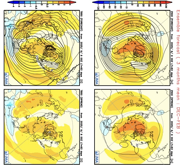
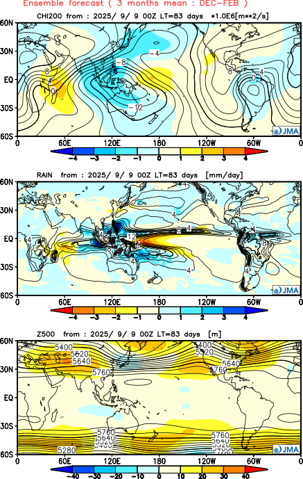
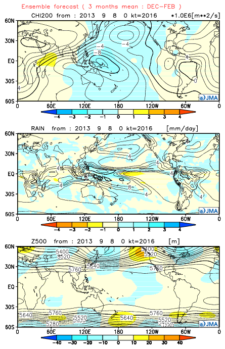
The JMA seasonal just updated for the winter. It was the only model that got the 2013-2014 winter correct with its fall forecasts. This time it has a much different look. It has a more +PNA pattern than we typically get with a La Niña. So it has a Baja ridge instead of the deep trough we had there in 2022-2023. My guess is that this is a continuation of the ridging and warm water we have been seeing near the West Coast this summer. In the East we have the familiar -AO Greenland block linking up with the Southeast ridge. So a milder winter in the East than last winter. As always these extended forecasts much of the time are low skill. So I just include here for informational purposes. https://ds.data.jma.go.jp/wmc/products/model/map/7mE/map1/zpcmap.php Famous forecast from September 2013 showing the record TNH winter
- Today
-

2025-2026 ENSO
donsutherland1 replied to 40/70 Benchmark's topic in Weather Forecasting and Discussion
The new measurement approach is an improvement. La Niñas, particularly weaker ones, would have been masked from a warming of the oceans. They were present, even if not acknowledged. -
0.15”. Here
-
I checked the gauge before bed at 11pm and had just over a tenth, so I was surprised to wake up to 0.71”
-
Mountain West Discussion
donsutherland1 replied to mayjawintastawm's topic in Central/Western States
I'm not arguing and have never argued that site changes didn't play any role in the shift in Denver (initial comment about Denver and afterward). I cited Denver, as it's Colorado's largest city, but the frequency in hot days has increased elsewhere, too. My subsequent comments highlighted that far more than site changes are involved in the big recent increase in 90° and 95° days. -

September 2025 OBS-Discussion centered NYC subforum
wdrag replied to wdrag's topic in New York City Metro
Yes... and it was my mistake not checking EC AI... it never had this EPS/CMCE solution. Drier GEFS was right. Now warmer pattern and I suspect smokey eventually next week from Canada. -

September 2025 OBS-Discussion centered NYC subforum
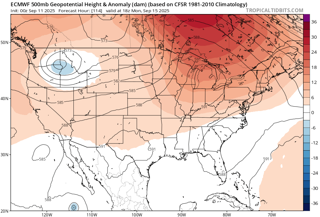
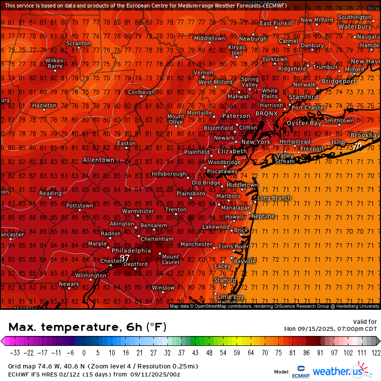
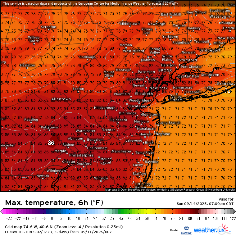
bluewave replied to wdrag's topic in New York City Metro
The Euro lost the cutoff low for early next week. It’s replaced by a 591 dm ridge to our west. So it has mid 80s from Sunday right into next week. New run Old run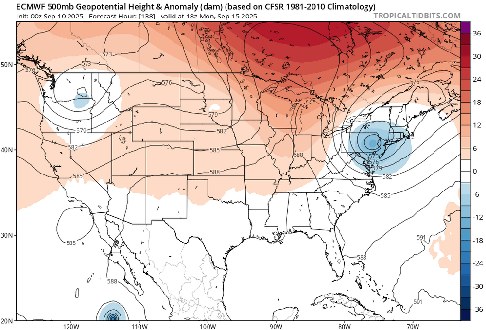


-
On a non-football note, I saw the new Spinal Tap movie last night. It was well done and I suggest seeing if you enjoyed the first one.
-
Over 0.5” last night! That was completely unexpected.
-
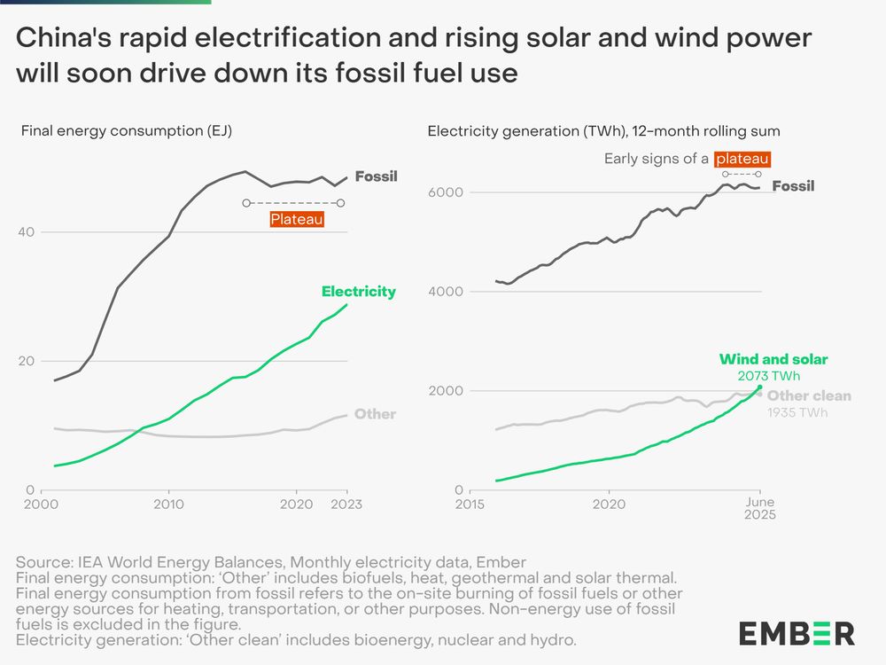
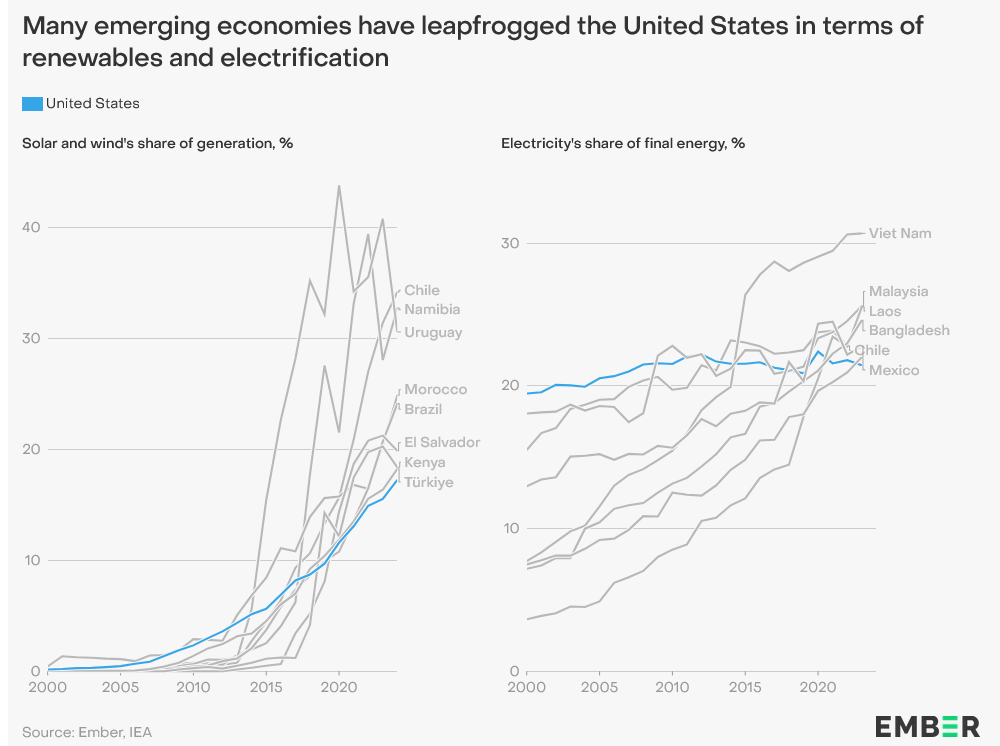
Clear we have passed an energy tipping point, with fossil fuels becoming increasingly uncompetitive. China's large manufacturing scale key in driving down costs. Countries without entrenched fossil fuel interests are leading the way and China will sell them the gear. https://ember-energy.org/latest-insights/china-energy-transition-review-2025/
-
Unlike last year when we were in a +AAM regime, this year we are and have been in a strong -AAM, so definitely much more Niña like in that respect @so_whats_happening Australia’s BOM has changed its parameters for La Niña classification:
-
The forecast here for the next 7 days looks like San Diego. Mostly sunny with a high around 80.
-
To my surprise (not surprised) it has rained all night here. Steady rain, sometimes heavy. I'd estimate another half inch at least. When does the dry spell start lol