All Activity
- Past hour
-
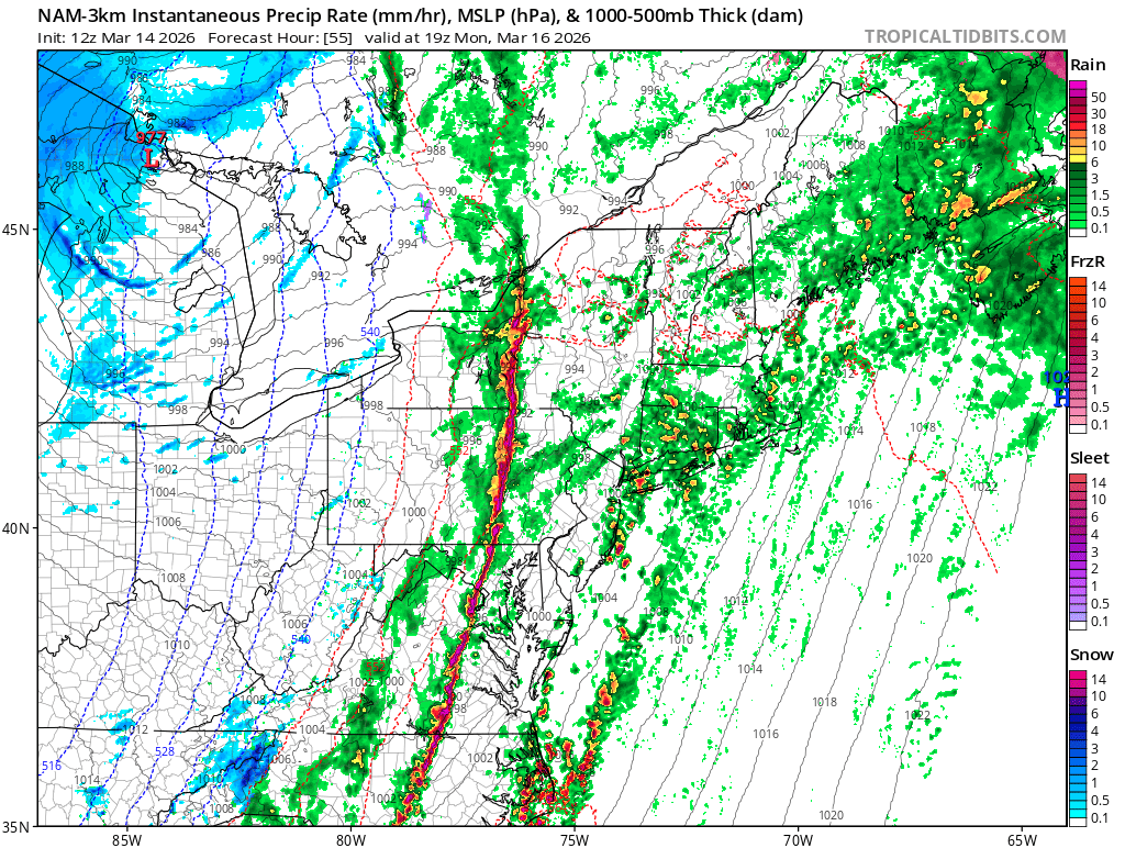
12z Nam has nasty line in the afternoon

-

2026 Mid-Atlantic Severe Storm General Discussion
high risk replied to Kmlwx's topic in Mid Atlantic
Yes and yes. The failures are way too many to note, but a famous day when we successfully recovered is the La Plata event. -
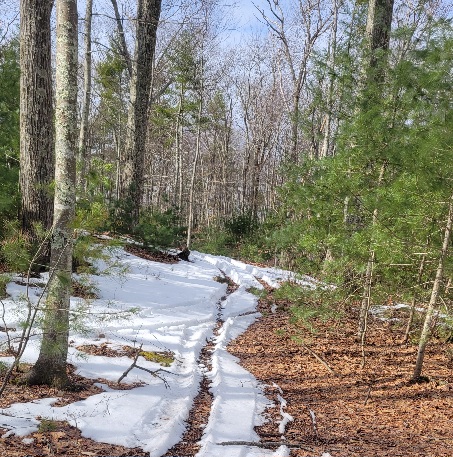
Not much left in the woods. Some in areas protected by hills.
-
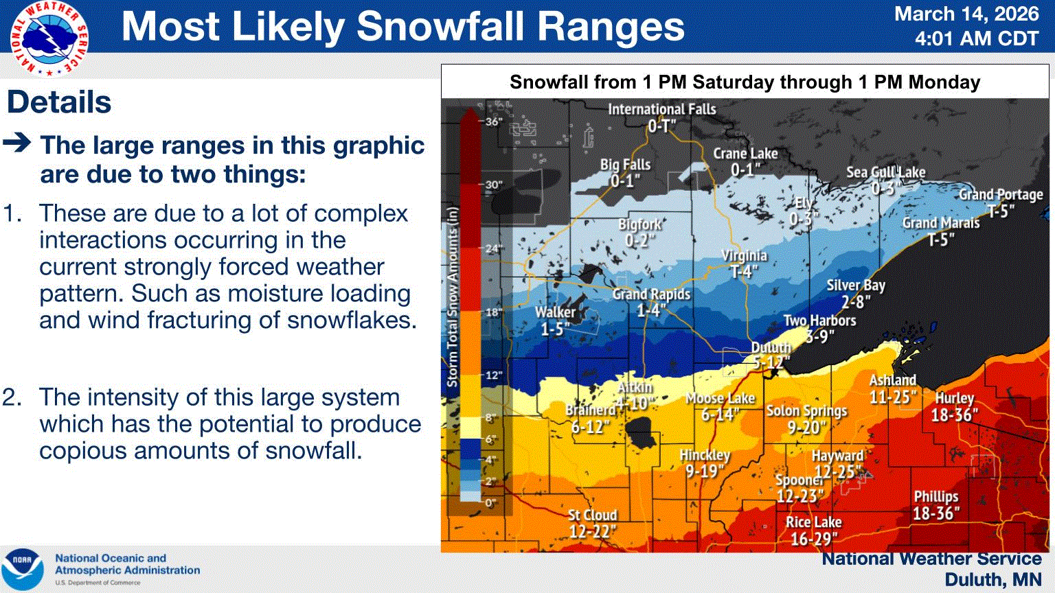
This surprised me this morning. Didn't think my area would see quite this much. I might even pick 3+". Guess L Superior will have it say, too.
-
Coldest SSTs on the Merrimack in years.
-
Snowpack starts getting weird this time of year depending on shading and angle to the sun.

-
-
-
I know you aren't...I just don't know what to say lol I also said in the post above, that while I'm not right on the Merrimack river bed, I am in a little valley...so am not surprised surrounding areas also get a bit more snow. That probably worked to my advantage om Thursday because I didn't mix out until the front was coming through.
-
I also don't mean to imply that there is a uniform 7" of snow on the ground throughout Methuen, either...certainly not the case. Lots of bare ground showing up and it's gone near the main roads and under trees. I'm sure there is more consistent coverage in Brian's area....but IMBY, which is not heavily shaded, there is still several inches.
-
My folks have piles, some snow in woods and a good chunk of backyard still covered as of yesterday.
-
I just said I’m not calling you a liar. Are you tucked into the river valley?
-
No, and there have been snowstorms on the spring equinox before (see 3/20/2015 and 3/21/2018). There won't be one this year.
-
IDK what to tell you...I'll take a photo with the yard stick...maybe the sleet slowed the melt....
-
Are there any notable events where recovery occurred from showers earlier in the day? Is it something we struggle to do around here?
-
2026 Mid-Atlantic Severe Storm General Discussion
high risk replied to Kmlwx's topic in Mid Atlantic
I think that’s reasonable, although climo says (and guidance agrees) that the best tornado threat will be even further south. -
It seems like some of the 12z guidance shifted everything earlier in the day. It could be noise this far out, but it’s something to watch.
-
2026 Mid-Atlantic Severe Storm General Discussion
high risk replied to Kmlwx's topic in Mid Atlantic
The high end potential is definitely there, but two things stand out 1) a clear trend towards earlier timing 2) a lot of guidance showing clouds and showers well ahead of the main forcing. With the right timing, the early convection could be supercells, but the trend towards an earlier event opens the door to insufficient time to recover after morning showers. -
The worst part about losing my pack before this event is having another round of mud.
-

2026 Mid-Atlantic Severe Storm General Discussion
Eskimo Joe replied to Kmlwx's topic in Mid Atlantic
We'll see. I would favor DC and points south for torandoes, maybe some rogue QLCS thingy in MD through Central PA. -
I just mean I was higher than you, cooler than you during the warmup, and we ended up tied at 8” the other day. Not calling you out. Just surprised I was losing snow faster than you.
-
2026 Mid-Atlantic Severe Storm General Discussion
high risk replied to Kmlwx's topic in Mid Atlantic
But is that too much shear for the very modest cape? -
2026 Mid-Atlantic Severe Storm General Discussion
Eskimo Joe replied to Kmlwx's topic in Mid Atlantic
70 - 125 kt shear on a neutral to negatively tilted trough in March is a recipe for a decent event. -

Pittsburgh/Western PA WINTER ‘25/‘26
Gordo74 replied to Burghblizz's topic in Upstate New York/Pennsylvania
Well don’t I look the fool for making fun of the ides of March storm and now I’ve been without power since 6pm with no ETA. -
In rare form this morning, ha.