All Activity
- Past hour
-
That was a guinea pig for diane
-
Peaks of sun on the shore today. Going to walk the beach and look at the big waves.
-

Hurricane Erin: 100 MPH - 954 mb - NNW @ 13
NJwx85 replied to BarryStantonGBP's topic in Tropical Headquarters
But that’s exactly what you’d expect as it starts to feel the effects of the trough. It’s already showing signs of becoming extra tropical. -
Cocgust in full swing…swinging back and forth slapping humid humpers backsides and heads.
-
Hurricane Erin: 100 MPH - 954 mb - NNW @ 13
NJwx85 replied to BarryStantonGBP's topic in Tropical Headquarters
There’s a noticeable eye showing up on IR and there was another blow up of convection near the center. Yes, there is some dry air but I think the moat you’re seeing is mainly due to the expanding system. Erin’s outflow is now reaching into Southern Virginia on the NW side. -

Hurricane Erin: 100 MPH - 954 mb - NNW @ 13
NorthHillsWx replied to BarryStantonGBP's topic in Tropical Headquarters
Recon reveals what most have been saying- a very broad system without a sharp inner core. Highest FL winds again well away from center and SFMR readings appear to show a lack of efficient mixing of winds to surface. Though the sat appearance has improved and pressure falls continue, this likely isn’t generating cat 2 winds at this juncture, just a large area of 60-75kt wind -
My July rainfall was 1.43". On August 1 I received .01". Scored big time this morning with .06".
-
 Rain in Brightwaters. Perfect weather to be a lifeguard. No beach goers, the water is warm, and the waves are calling. Body surf time. PSA: only the strongest of swimmers should enter the water today.
 -
People SOP sweating the current radar, even though the bulk of the precip down here isn't til later tonight. And yeah, most or all models have it.
-
Are the prayer hands ineedweenies?
-
He needs to be fired, or given an ultimatum to improve the team through free agency. Every prospect can't be off limits. The guy is weird.
-
Nice soaking rain here all morning.
-

Hurricane Erin: 100 MPH - 954 mb - NNW @ 13
wthrmn654 replied to BarryStantonGBP's topic in Tropical Headquarters
Buoy 41047 which was east of Erin, I think had instruments destroyed or is batteries are in bad shape.... it stopped sending wind speed last night bearing 70knts but still was sending wave and pressure readings. Waves at 40 feet might i add and a pressure reading as low at 29.15mb -
 68 / 65 clouds and onshore flow with Erin slowly crawling north well offshore. Rain so far well nort into NYS and N-PA. Rain today / Thu 1 -2/3 in localized spots - we'll see. Clear out and dry out overnight Thu into Fri. Another mainly dry weekend and a bit warmer, especially Saturday. Clouds arrive later on Sunday. Timing of front Sunday seems to be later in the evening and night into Monday with next round of rain/storms. Trough into the northeast most of the week with ridge building east and warmer by the very close of the month 31st. Warmer beyond. 8/20 - 8/21: Clouds / rain enhanced by a well ofshore Erin 8/22 - 8/24 : Warmer Drier / Sunday clouds up later 8/25 - 8/30: Trough into the northeast / cooler 8/31 - beyond : Ridge expanding / warmer
 -
Who is the gerbil near Plymouth?
-
Nobody listens
-
Am off work this week to spend with the kiddo before school starts next week. Been great to sleep in hahaha. Over the cloudy dreary days tho, haven’t gotten out of the 70s, woke to drizzle this morning.
-
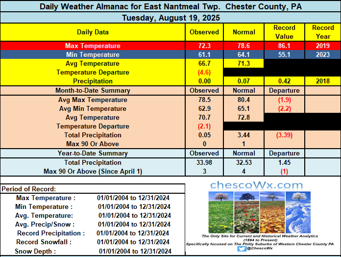
We saw some light rain amounts overnight and this early AM including 0.05" at both Glenmoore and East Nantmeal. Shower chances will continue both today and tomorrow with continued cooler than normal temperatures. We clear up Friday and Saturday with our temperatures rebounding to near normal before a cold front moves through on Sunday which will allow for the return of an autumnal feel in the air.
-

E PA/NJ/DE Summer 2025 Obs/Discussion
ChescoWx replied to Hurricane Agnes's topic in Philadelphia Region
We saw some light rain amounts overnight and this early AM including 0.05" at both Glenmoore and East Nantmeal. Shower chances will continue both today and tomorrow with continued cooler than normal temperatures. We clear up Friday and Saturday with our temperatures rebounding to near normal before a cold front moves through on Sunday which will allow for the return of an autumnal feel in the air.
-

Hurricane Erin: 100 MPH - 954 mb - NNW @ 13
olafminesaw replied to BarryStantonGBP's topic in Tropical Headquarters
Yeah, I've seen this with some WPAC hurricanes where it builds a massive outer eyewall which has hurricane force winds and the inner eyewall remains quite weak relative to the pressure. -

Hurricane Erin: 100 MPH - 954 mb - NNW @ 13
Windspeed replied to BarryStantonGBP's topic in Tropical Headquarters
Looks like we're in the spiral galaxy phase of Erin's lifecycle... lol -
Best rain flying north. We need it
-
Elias will absolutely blow smoke up our collective asses that a rotation of Rogers, Kremer, Rodriguez, Bradish, and Wells/Povich/Suarez/whomever can go all the way next season and it’s a joke.
-
Nothing on radar but some drizzle and even light rain on my way to work and back home (forgot my ID card) and back again
-
0.02” may be it. I’m ready for a synoptic drizzle fest.


.thumb.png.4150b06c63a21f61052e47a612bf1818.png)


