All Activity
- Past hour
-
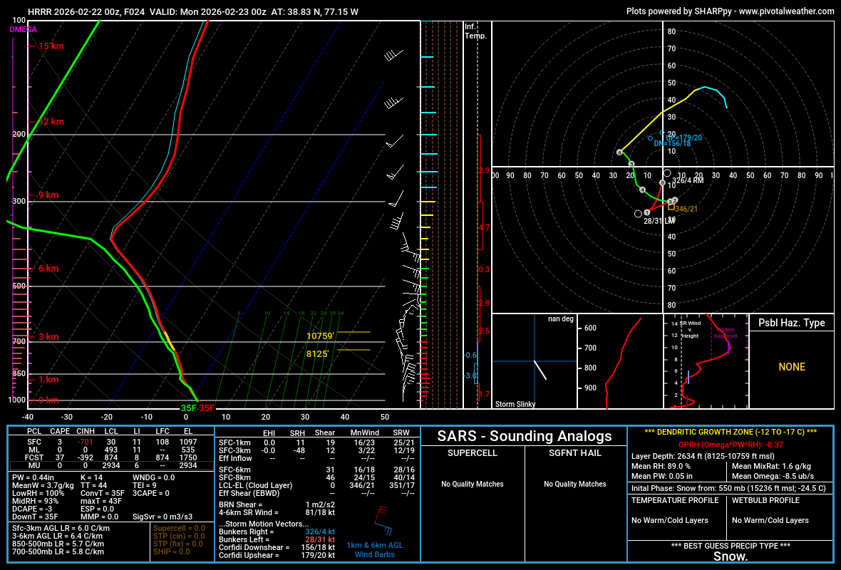
Hrrr is toasty. 37 for a high imby tomorrow. Probably white rain for a time.
-
More like anything past 0hr. I’m not the only one here that feels that way too. I know Will goes on SREFs rants because they pulled the spectral RSMs out for the ARWs.
-

Feb 22nd/23rd "There's no way..." Obs Thread
Solution Man replied to Maestrobjwa's topic in Mid Atlantic
That’s what I was thinking with its counter clockwise circulation -
HRRR has a known warm bias
-
LOL!! I am way too west for this one!!
-
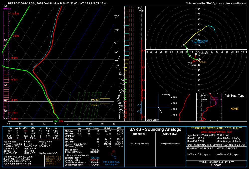
If this is the sounding at 0z near dc, we will struggle
-

“Cory’s in NYC! Let’s HECS!” Feb. 22-24 Disco
40/70 Benchmark replied to TheSnowman's topic in New England
Oh yea...I'm sure the Nemo 8"/hr or whatever will be SW of me....but I doubt I get under a foot. -
Just curious Which Adams? .
-

Central PA Winter 25/26 Discussion and Obs
AMDEW80 replied to MAG5035's topic in Upstate New York/Pennsylvania
Not expecting too much up this way, but it has been a fun week of modeling! I hope we get an unexpected tuck and the whole forum over performs. So much potential… but seems to be wide right at this point for a big one. (For central/northern pa). Everyone enjoy! -
That's hot!
-
Looking forward to possible thundersnow tomorrow night.
-
I don’t even find the FV3, ARWs, and SREFs useable. RAP I forget exists. HRRR starts falling off a cliff after 12-24hr. But I’m sure the NWS likes it because the high res must help them fill their zones in the short range.
-
I'm excited to see some high-ratio fluff with this, even if it's less than the 15" of grains from last month. That's something that's been lacking so far this season.
-

The February 22-23 Late Season Miracle: JV Disco/Banter Thread
Maestrobjwa replied to bncho's topic in Mid Atlantic
Well for starters...this And this And other such recent runs looking better up top and still the same crap in the middle.
-

Feb 22nd/23rd "There's no way..." Obs Thread
mitchnick replied to Maestrobjwa's topic in Mid Atlantic
It comes with moving it west. -

Feb 22nd/23rd "There's no way..." Obs Thread
aldie 22 replied to Maestrobjwa's topic in Mid Atlantic
Could tug it further west i suppose -
The January event ticked upwards right up until the event was underway. Went into it thinking about 1” or a little more of liquid and ended up with 1.5”. Totally different setup between this and that of course but it got wetter right up until the event.
-
This explains it well, with graphics. Note, it’s from a met up in the Maine area, but synoptic details apply all the same https://forecasterjack.com/glossary/glossary-of-cold-season-terms/norlun-trough/
-
just made a bet on gemini for central park to get 15+ inches for the month of february i think that's free money.
-
For 20-42hrs? I agree that they can get pretty erratic past one daytime cycle and I've mentioned that before. It's a weird gray zone for modeling (24-48hrs), but I'm sure NCEP created those weights with solid reasoning/evidence/support.
-

Central PA Winter 25/26 Discussion and Obs
Mount Joy Snowman replied to MAG5035's topic in Upstate New York/Pennsylvania
HRRR through the afternoon tomorrow with much less precip and more rain influence. Not that there was much snow accumulation by that point anyway but something to monitor. Probably just pushing everything back timewise. We'll see. -
September 1963.
-

Feb 22nd/23rd "There's no way..." Obs Thread
Weather Will replied to Maestrobjwa's topic in Mid Atlantic
Busy day and getting caught up. Lot of talk about the low hugging the coast or going west. My non expert observation is that the reason we don't get slammed further west/ south is because the low intensifies parallel to the Delmarva rather than further south say off of Norfolk. If the storm intensifies faster than forecast and hugs the coast then the NW burbs could get heavier snow. Also, can someone better explain the IVT? I still don't get it. Thanks. -

“Cory’s in NYC! Let’s HECS!” Feb. 22-24 Disco
ineedsnow replied to TheSnowman's topic in New England
0z HRRR out to 20 and looks almost exact to 18z so far -
Strong possibility of widespread power outages


(002).thumb.png.6e3d9d46bca5fe41aab7a74871dd8af8.png)