All Activity
- Past hour
-

November 2025 general discussions and probable topic derailings ...
CoastalWx replied to Typhoon Tip's topic in New England
It’s not fast Pacific flow. Quite the opposite with the ridging. You’re getting confused. -

2025-2026 ENSO
40/70 Benchmark replied to 40/70 Benchmark's topic in Weather Forecasting and Discussion
I think a bias requires an actual forecast. I would admit that you you use reverse psychology as a defense mechanism if I were you. -
 I’m not throwing any towels in yet. I’m quite sure we’ll have a few accumulating snow storms in Dec.. but the duration of the favorable period shrinking this week , losing the NAO.. is a growing worry. Weeklies last year looked good almost each run and we know how that worked. I’ve hated the look of the fast flow Pacific flow all autumn .. allowing for 1 coastal and any others blowing up over the Stellwagen Bank . All that allows for are fast moving lake cutters and windy CAA. If trends continue negatively the next few few days .. we’ll all be throwing in our towels into a pile in the lockeroom looking at each others limply hanging junk .
 -

November 2025 general discussions and probable topic derailings ...
WinterWolf replied to Typhoon Tip's topic in New England
This is so silly.. -

Central PA Fall Discussions and Obs
Jns2183 replied to ChescoWx's topic in Upstate New York/Pennsylvania
@canderson Everytime I watch his videos and see his Texas and Texas a&m characters I can't help but envision your family down there. Sent from my SM-G970U1 using Tapatalk -
Once the MJO gets to phase 8 , it kills the southeast ridge and then the the polar vortex presses in. The coldest part of December is likely from the 15th to the 25th.
-
Rain to wet snow, then it'll freeze up to a ice block. Typical early season snow. UP MI looking at 3ft in some spots with syn/LES combo. Here in town, I think 6" would be a big surprise. 4" max is my thinking. Warm lake. But higher terrain should do well. NWS DLH is good at overestimating. Most storms barely hit min guidance around TH.
-

Nov 28-30th Post Turkey Day Wintry Potential
A-L-E-K replied to Chicago Storm's topic in Lakes/Ohio Valley
-
The OL is NOT good. Especially the guards. He drafted Emery Jones- a raw talent, but knowing he wouldn't be available anytime soon coming off surgery. What other moves did he make to improve the line? He was also gaslighting about how improved Faalele was, will get better, etc. Why did he not replace Warhop given his track record? His franchise QB is paying the price for the piss-poor line play.
-

Nov 28-30th Post Turkey Day Wintry Potential
ILSNOW replied to Chicago Storm's topic in Lakes/Ohio Valley
12z Icon welcome aboard -

November 2025 general discussions and probable topic derailings ...
ORH_wxman replied to Typhoon Tip's topic in New England
Too much absolutism here. We don’t even know how things will look beyond about 12/14….weeklies actually load a bit of a western ridge leading into Xmas week. Don’t know if I buy it, but there’s plenty of ways to snow if we can keep frigid air in Canada close by which looks to be the case at least. Our glory days of December had cutters too in the 2000s…they are likely to happen. -

2025-2026 ENSO
TheClimateChanger replied to 40/70 Benchmark's topic in Weather Forecasting and Discussion
Could be a case of delayed, but not denied, as JB often says. I wouldn't throw in the towel just yet. Suspect we'll see some more SE ridge mischief as we head into the month of December. -

November 2025 general discussions and probable topic derailings ...
dendrite replied to Typhoon Tip's topic in New England
He does it every Nov/Dec. Investing way too early for his climo. He needs to move up to Glens Falls or Binghamton and handle some real crime…like not putting on your blinker at a stop sign. -
Its coming! ❄️
-

November 2025 general discussions and probable topic derailings ...
Torch Tiger replied to Typhoon Tip's topic in New England
yeah it's disappointing to see everything slip away like that. Especially with the tremendous SSW hype and etc. -
2025-2026 ENSO
TheClimateChanger replied to 40/70 Benchmark's topic in Weather Forecasting and Discussion
Thanks for the update, Don. This looks similar to the wintertime pattern I got when I ran the warmest CONUS Novembers forward, with cold in the Upper Midwest and Pacific Northwest. Warm south and east, with a stout SE Ridge. Hoping the ridge is underestimated a bit and milder air is able to infiltrate the Great Lakes region as well as we head into mid December. -
November 2025 general discussions and probable topic derailings ...
CoastalWx replied to Typhoon Tip's topic in New England
He knows NYC is toast -
November 2025 general discussions and probable topic derailings ...
dendrite replied to Typhoon Tip's topic in New England
LR models warm…they’re horrendous LR models cold…we take and we post -
November 2025 general discussions and probable topic derailings ...
CoastalWx replied to Typhoon Tip's topic in New England
You can’t say that. But I wasn’t a fan of how guidance lost the NAO ridging over the last two weeks. I think we’re gonna have some chances, fingers crossed. -
I like how we all gave MJO812 weenie emojis for saying everyone overestimating SE ridge and he was completely validated. I will admit I have a warm bias. Maybe some others should step up and admit it too.
-
Certainly slipping away for a good month south of there
-
damn good point
-
Thoughts are you should wait a few days before even considering something 8 days out a possibility.
-
All guidance appears to be "struggling" with the amplitude of shortwaves coming down the ridge from AK to CA. This is an area where minor perturbations grow into mature trofs or deep upper lows. It may or may not also be a data sparse region. This is leading to huge intra-and inter-model variability with respect to west coast trofs, their amplitude, and which is dominant.
-
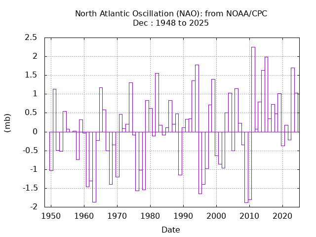
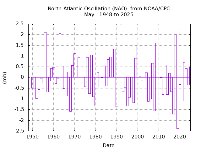
December has been one of the most challenging months for sustaining deep -NAO patterns since 2011. Pretty much the opposite of May. This is one of the reasons why we haven’t seen a repeat of record December snows from 2000 to 2010 around NYC.