All Activity
- Past hour
-
Ouch https://www.wcax.com/2025/05/19/cow-survives-getting-impaled-by-lumber-during-tornado-that-destroyed-dairy-farm/?utm_source=taboola&utm_medium=organicclicks&tbref=hp
-
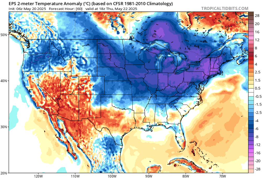
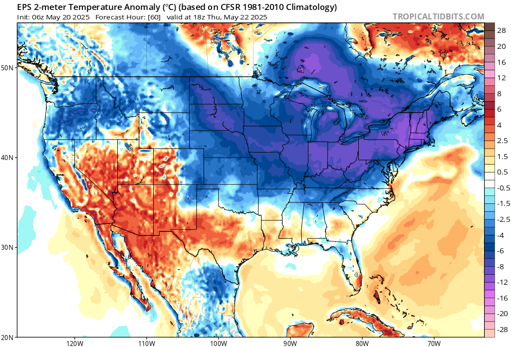
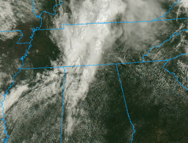
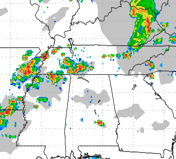
And just like that.. Mississippi, Alabama and Tennessee boundary ahead of the Delta front is back. 00/06Z too much midday rain was forecast, keeping it stable. Now most progs have the morning rain dissipating, leaving a cooking boundary. Satellite shows very little cloud cover in its wake. Just bake. 10:45 CDT and the RRFS later, not that it'll really verify that bullish. Just remember Southern weather forecasting is like a box of chocolates.
-
I’m going to have to turn the pellet stove on.
-

2025-2026 ENSO
PhiEaglesfan712 replied to 40/70 Benchmark's topic in Weather Forecasting and Discussion
In a warming climate, I think a 2009-10 type year in the future is going to be near impossible. We're never going to get a strong el nino produce such a cold winter in the CONUS. Just look at 2015-16 and 2023-24, which were record breaking warm winters in the CONUS. If we are to get a cold winter in the CONUS in the future, it will almost certainly be a la nina year, and most likely a strong one (like 2007-08 or 2010-11). -

2025-2026 ENSO
40/70 Benchmark replied to 40/70 Benchmark's topic in Weather Forecasting and Discussion
Great, the climatechanger and Bluewave taking over the ENSO thread.....stand by for mass suicide attempts. -

2025-2026 ENSO
michsnowfreak replied to 40/70 Benchmark's topic in Weather Forecasting and Discussion
So youre thinking that means we are in for an ENSO neutral winter of some sort? -
 MANDA changed their profile photo
 -
a bunch of people here don't post at all when april starts
-
Just great weather (a bit windy) last few days. Low was 41 here this morning. Great sleeping with the windows open and the blankets up! Not going to go on much longer so I'm enjoying it while it's here. The muggy and sultry weather will be here soon enough. Meanwhile everyday without it is one less day we have to deal with it.
-
2025-2026 ENSO
michsnowfreak replied to 40/70 Benchmark's topic in Weather Forecasting and Discussion
And here we go YET AGAIN highlighting the coldest stretch of winters on record. For starters, DTW wasnt even the official climate site for Detroit until 1966-67. It was so rural that as has been pointed out ENDLESS times it was often a cold spot in the region with amazing radiational cooling (similar to present day Ann Arbor)...its no longer the case. All you have to do is compare the difference in temps between DTW and several other sites from the 1960s/70s and then 2010s/20s and you will see the margin is much smaller now. But these assertions about '90s winters lately are just WILD to me. The 1990s winters were EASILY the worst decade of winters of my lifetime, both the warmest AND least snowy (2020s TBD). 1980s, 2000s, and 2010s were far superior - and guess what, 2020s are only half over. I will comment on them in 2030 when they are over and given the same playing field as the rest. As it stands now, of FULL decades, the warmest winters on record are the 1990s, followed by the 1950s then 1930s. AVG DJF WINTER TEMPS & annual snowfall - Detroit 1870s – 25.2 (*1874-79) 1880s – 27.6F - 43.1" 1890s – 26.5F - 42.7" 1900s – 24.9F - 46.3" 1910s – 25.5F - 39.7" 1920s – 25.8F - 46.1" 1930s – 28.3F - 32.9" 1940s – 27.0F - 27.8" 1950s – 28.6F - 37.8" 1960s – 26.2F - 31.8" 1970s – 24.8F - 45.6" 1980s – 25.9F - 45.2" 1990s – 29.2F - 37.9" 2000s – 27.7F - 45.3" 2010s – 28.2F - 49.9" 2020s – 30.5F - 35.5" (*only thru '24-25) -
Looks like about 96 hours of clouds starting later this afternoon.
-
forky only posts when he is sure hot weather is coming..
-
I guess comparatively, Monday will be "decent" but that's not really saying much. I would think we still have a quite a bit of clouds around. There will be a bit of a breeze too, especially eastern areas and it will be a chilly breeze too. Not sure anyone really gets close to 70...probably 65-68 for warmest readings. At least it will be dry I guess
-
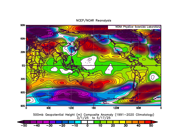
The WPAC warm pool seems to be driving the very potent La Niña background this spring. Notice how we continue to see the Aleutian Ridge displaced further west than usual. Looks like the very strong IO into WPAC forcing wants to gradually shift east as we head into early June. Perhaps an attempt for some WWB activity which could weaken the trades a bit from the strong present levels. Whether the ENSO regions register -0.5 or +0.5 in the coming months may not matter as much as how warm the WPAC is which would drive the La Niña background even if the ENSO regions are technically neutral.
-
I love how you can time the low frequency of forky posts with cold snaps.
-
I think it has to do more with the fact that a temperature swing like that is like a shock to the body which can impact the immune system negatively.
-
Hilarious that the weather service there suggests "adding layers" to prevent catching a cold. I will boldly state that a temperature drop from 41c to 26c has no impact on the transmissibility of a cold virus.
-
Meh still a few things that could screw that up and still 6 days out.. not awt yet And congrats central and Northern VT/NH on the 12z NAM
- Today
-
AWT
-
Big coc out there. Enjoy before it slips away for a while…
-
Djf
-

2025-2026 ENSO
TheClimateChanger replied to 40/70 Benchmark's topic in Weather Forecasting and Discussion
Again, you are reading things that I didn't say. I mean a 1995-1996 or 2009-2010 type year. As @bluewavepointed out, even relative to 2013, the available pool of arctic air is much smaller. If the 2030s are as much above normal as recent decades, PHL could see a decadal winter mean of ~38F. That is on par with the late 20th century average at Richmond, Virginia. Snowfall averaged around 16-17 inches at Richmond in this era, with high snowfall years around 40" or so. This really isn't super different from PHL's average of ~21-22 inches, but I would probably expect mean snowfall to fall more into that range over the next 15 years. And PHL has only seen a few years with substantially more than 40" in the last few decades anyway. -
That's news to me. March and April were above to well above normal. And so far so is May.
-
We've had worse.
-
You heat lovers have the whole planet's atmospheric changes on your side. Let us enjoy a handful of cool crisp mornings.
-
The record low maxes for the 22nd should be in play. EWR…56°…..2003 NYC….54°…..1894 LGA…..57°…..2003 JFK…..55°……1967 ISP……54°……2003