All Activity
- Past hour
-
Another nice month? April was a washout. Even with a garbage blocking pattern taking place this weekend into next week....
-
Some last minute rain to close out the month with 0.02". Final total for the month is 6.15", still making it the 8th wettest April on record. Top 10 Wettest Aprils (DAY): 1. 9.20" - 1996 2. 8.72" - 2011 3. 6.95" - 1947 4. 6.78" - 1993 5. 6.52" - 1989 6. 6.32" - 1994 7. 6.19" - 1998 8. 6.15" - 2025 9. 5.98" - 1964 10. 5.87" - 1911 Cincinnati had an additional 0.18" to close out the month. Final total for the month is 7.47", making it their 5th wettest April on record. Top 5 Wettest Aprils (CVG): 1. 13.52" - 2011 2. 9.77" - 1998 3. 8.36" - 1947 4. 8.20" - 1996 5. 7.47" - 2025 I had a feeling that was coming all along thanks to the very wet start to the month.
- Today
-
 DCA _ NYC _ BOS __ ORD _ ATL _ IAH ___ DEN _ PHX _ SEA +1.4 +1.6 +1.7 +1.9 +.5 -.2 +1.5 +.3 +.5 Oh man almost forgot
 -
 +1.3 _ +1.4 _ +1.5 _ +1.2 _ +0.7 _ +0.5 _ +2.7 _ +1.0 _ +1.5
 -
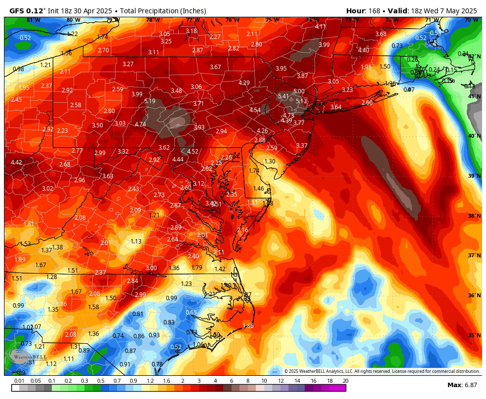
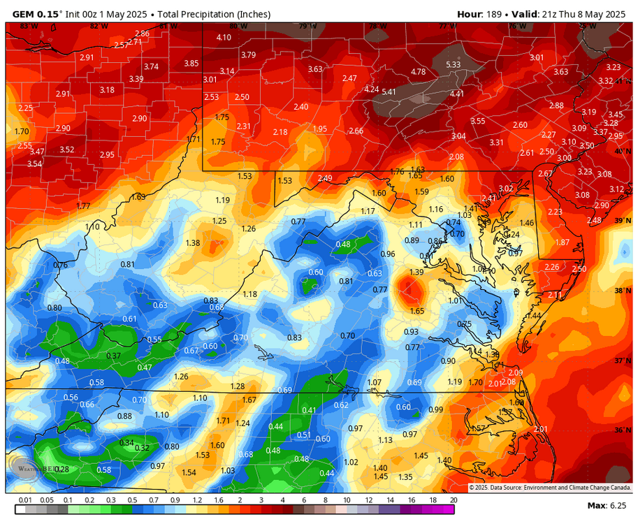
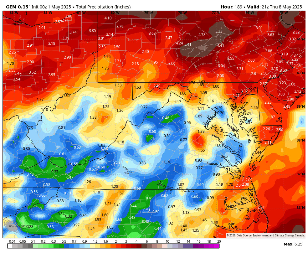
The 00z 5-1 GEM pushes the heavy rains north into Pennsylvania.
-
bring on the rain!
-
Precipitation is precipitation, winter or summer when looking 1 - 7 days into the future. The greater the expected sum total, the greater the error factor. The WPC has already changed significantly in the past 20 hrs. with qp amounts for the next 7 days.
-
.thumb.png.04fd405fc20533e2e1f82f89c938ca75.png)
-
-
My power came back on around 4 today. Hopefully tomorrow's round isn't as bad as this was, at least wind wise. People are still without power but it's thankfully dwindling down. They got a lot of help from neighboring states with this. Otherwise, some of us may have been out for days.
-
 DCA: +1.4 NYC: +1.6 BOS: +1.8 ORD: +2.9 ATL: +0.4 IAH: -0.6 DEN: +1.1 PHX: +0.1 SEA: +1.0
 -
Rooting for the drought stricken areas. I don't really even need the rain here but I will take it just for some sort of excitement lol. Gimmie some damn thunder.
-
Niiiice! FINALLY no 95 s/e gradient
-
Looking great for a big soaking later in the weekend into at least early next week. Note that there is a separate thread for this event.
-
Up to 6.2” rain tonight. Very impressive.
-
Os took 2 outa 3 from the yanks, with 2 one run win bookends, and a blowout loss by the yanks in the middle game. Not pretty overall but decent starting pitching/some clutch hitting and great relief pitching did the trick. Still a mystery where consistent/effective starting pitching comes from going forward. RN Sugano looks like the ace.
-
43.6/25 Gonna be close by morning
-
 DCA: +1.8 NYC: +1.9 BOS: +1.7 ORD: +2.1 ATL: +1.4 IAH: +1.1 DEN: +1.5 PHX: +0.5 SEA: +0.4
 -
Wow. Reading today about much of the PSU campus/State College still with no power, and trees down everywhere. I never saw anything that bad when I was there.
-
Caps on to 2nd round.
-
May already? Geeze. Looking forward to pollen-washing and drought denting rains.
-
Forecast Discussion Sunday May 25 2025 3:08PM EDT This has been a destructively wet month for much of the region with back-to-back coastal lows/ nor’easters dropping 3-7” and 5-10” of rain across the forecast area. Followed by rounds of, sometimes, training thunderstorms early this past week tracking from WSW to ENE dumping another 4 inches to up to a foot of rain with parts of Montgomery and Howard counties into Baltimore getting those 10-12”+ totals. Needless to say, the drought that has been affecting much of the region over the last year or so has come to an abrupt end. Now this afternoon, another very dangerous situation is in the process of unfolding. An MCS is currently moving across northern MD with severe thunderstorm warnings out for wind damage as well as severe hail. A Severe Thunderstorm Watch is in effect for everyone north of Fredericksburg and Culpeper, VA and north of southern MD until 10pm local time tonight to account for these storms and training thunderstorms that will develop over the Greater DC metro. With 2000+ J/kg MLCAPE and decent effective bulk-shear (~40kts) there could be embedded supercell structures that produce severe hail (1-2” in diameter). The magnitude of CAPE and moisture will cause localized strong to severe downburst winds with any embedded downbursts/microbursts as well. The main story this afternoon and evening, however, will be from flash flooding from the storms that will start training over the same areas for several hours. Have issued a Flash Flood Watch is in effect for the entire forecast area until 4am. Decent low-level southerly flow will allow the storms that develop and back build to the south and west of the main MCS to be continuously reinvigorated as warm/moist/unstable air continuously lifts as it meets with the rain-cooled airmass to the north. Pwats of 1.75-2”+ will also make these storms efficient rainmakers. As a result, some areas could get several hours of 1-3”/hr rainfall rates leading to rainfall totals as high as 8-12” w/ locally higher amounts. A wave of energy will move along the front through the region this evening briefly allowing rain and storms to become more widespread. There could still be a few severe storms, mainly from the Potomac River and Route 50 southwards in MD where the airmass will be most unstable. As the wave moves to the east all the rain and storms will move out with it, exiting the Chesapeake Bay by 3am or so. However, the damage will be done by then. We will get another brief reprieve through midweek with slightly above average temps and humidity (High in the 80s w/ mid/upper 60s dewpoints) before, unfortunately, our attention turns to newly formed Tropical Storm Barry located in the western Caribbean Sea. Models are slowly starting to come into better agreement that Barry will move north and then northeast across Florida before interacting with a shortwave trough that may pull the storm back north into eastern North Carolina or into the Chesapeake Bay by late week bringing a threat of significant rains as well as gusty winds depending on how strong the tropical system is.
-
Thanks, just fixed it.

-
Isn't that the 12z Euro?
-
There is a bit of a signal for the highest amounts being north of here, but all 3 global ensemble means are 2"+ for most of this subforum, and 2 out of 3 have 2+" for the entire subforum. And it's spread out over multiple days instead of being some convective deluge that can't sink in. This looks a much-needed huge win for our region.


.png.0ae2b6706e6e2080d77f983e48c3b12e.png)