All Activity
- Past hour
-
.thumb.jpg.6a4895b2a43f87359e4e7d04a6fa0d14.jpg)
Central PA Spring 2026 Discussion/Obs Thread
Yardstickgozinya replied to Voyager's topic in Upstate New York/Pennsylvania
I think most of us realize expansion this time of year is many times the likely outcome . I wonder if anybody here could figure out the likelihood of spc expansions versus, reduction versus a consistent forecast in the final 24 and 8 hours before zero hour. -
Central PA Spring 2026 Discussion/Obs Thread
Yardstickgozinya replied to Voyager's topic in Upstate New York/Pennsylvania
Wpc has highlighted a marginal risk for excessive rainfall ,to include all but, South central and South eastern Pennsylvania. https://www.wpc.ncep.noaa.gov/qpf/ero.php?opt=curr&day=1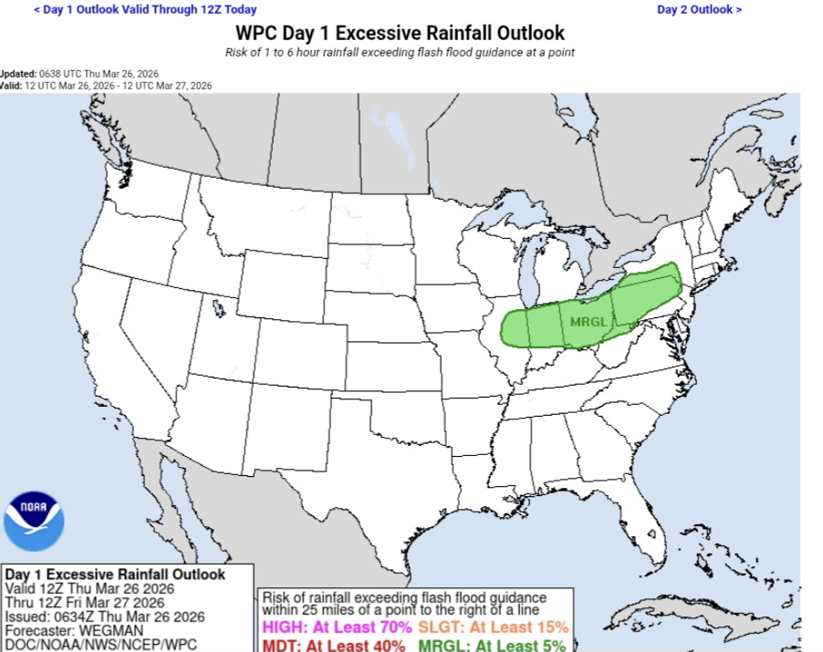
-
Central PA Spring 2026 Discussion/Obs Thread
Yardstickgozinya replied to Voyager's topic in Upstate New York/Pennsylvania
Nws forecast discussion concerning this evening and tonight's thunderstorms and potentially heavy rain. Highlight Changed Discussion -- 755 FXUS61 KCTP 260823 AFDCTP Area Forecast Discussion National Weather Service State College PA 423 AM EDT Thu Mar 26 2026 .WHAT HAS CHANGED... * Leaning warmer with max temperature forecast today * SPC severe t-storm and WPC excessive rain outlooks expanded && .KEY MESSAGES... 1) Noticeable warmup today will precede rain and thunderstorms this evening followed by a chilly/raw cool down for the end of the week into the last weekend of March && .DISCUSSION... KEY MESSAGE 1: Noticeable warmup today will precede rain and thunderstorms this evening followed by a chilly/raw cool down for the end of the week into the last weekend of March Partly to mostly cloudy and relatively mild start today as south to southwest flow ramps up ahead of strong cold front moving southeast from the Lower Great Lakes. We still expect rain free conditions in most places to last into the afternoon (through 18Z) although can`t rule out a passing shower in the increasingly moist warm air advection pattern. Breaks in the clouds combined with the southwest breeze will support a very warm day relative to late March climo - with fcst max temps in the 65-75F range or +15-25 degrees above the historical average/within 5 degrees or so of daily record highs (see climate section). The aforementioned strong cold front will provide the primary forcing for a band of rain and thunderstorms to track from NW to SE across central PA this evening through tonight. SPC has extended the MRGL and SLGT risk convective outlooks farther eastward into western and central PA, however calibrated severe storm probs continue to focus the greatest hail/wind/tor risk in the Ohio Valley where CAPE and shear profiles are more insync. Influx of 1-1.5" pwats brings the prospect of locally heavy rainfall more into play and fcst QPF amounts have increased a bit particularly over southwest PA. It`s not clear how much fast movement and average soil moisture can be offset by training storms and orographics, but like the severe t-storm risk, the probability of runoff issues has increased on the margin and WPC will be monitoring for a targeted upgrade in the ERO. The highest rainfall totals are 1.50-2.00 inches in the Laurel Highlands. -
Central PA Spring 2026 Discussion/Obs Thread
Yardstickgozinya replied to Voyager's topic in Upstate New York/Pennsylvania
Slight risk expanded into Western Pennsylvania Marginal Expanded well into central pennsylvania. https://www.spc.noaa.gov/products/outlook/day1otlk.html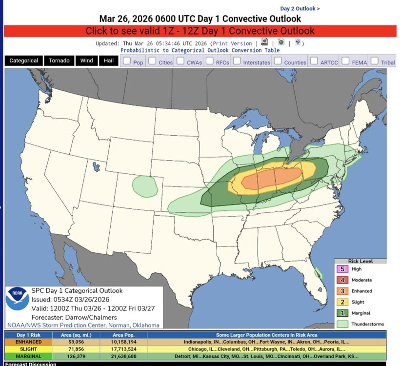
-
It looks like a ton of rain the next two weeks.. its all good though the drought monitor will tell us we're still in a drought
- Today
-
If its going to be 90+ degrees... there better be a chance of storms too If its -10F... better be snowing. -10F and sunny skies can gtfo
-
But you're not surprised, right? A week ago I said the 60's (to low 70's) we had two weeks ago, were the highest temps until Memorial Day. Just pray for sunny days, is the best you can do.
-

Phoenix Experiences Warmest February and Winter on Record
donsutherland1 replied to donsutherland1's topic in Climate Change
And the updated chart: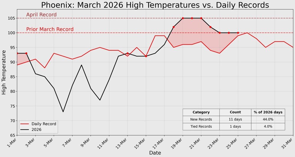
-
6 year old me hanging from his basketball hoop
-
 Just so we are all on the same boat as for locations with February anomalies: DCA: Washington Reagan (-3.8) NYC: Are we using JFK, LGA, or central park data? (-4.7, -4.6, -4.4 respectively) BOS: Logan Airport (-3.3) ORD: O'Hare or Midway? (+4.3, +3.9) ATL: Hartsfield (+3.1) IAH: Houston Bush (+6.1) DEN: Denver is a tricky one with the airport like 5 miles away from downtown but there is a Denver central park site (https://www.weather.gov/wrh/climate?wfo=bou) (+9) PHX: Phoenix Airport (+7.8) SEA: Seattle-Tacoma or Boeing Field? (+0.4, +1.1) Any input/changes are appreciated!
 -
I'm just biding my time right now. I will be in Ft. Wayne until 6-ish for my maintenance chemo. Will be keeping a close eye on radar so maybe I can get out of Dodge before the storms get here for a back yard chase, but will try to stay out from under any stones. Will have the wife with me who hates to chase, but she will be recruited if need be. lol
-
Agreed. Not sure what SPC is seeing. That cf really surges south fast.
-
Next 10 days look miserable. This time of year blows
-
Give this man a gold start. Amen.
-
You are in good shape, Jerry...lots of folks maintain vitality and independence into their 90s...you keep active, too...physically and mentally. I Look forward to exchanging obs during winter 2037-2038....if Tip doesn't engineer to have the sun swallow us whole by then.
-
-
Y'all are crazy. I'd much prefer -10F than 90F. If it's 90F it better be 20% RH and breezy.
-
I would be down to keep giving it a try. As for scoring this may take time to figure out but we can at least post the results for each month as well as snowfall and Max temps. I think it would be great to keep it going in honor of Roger.
-
 We can score it our own way. I have no idea how he scored things but if someone comes up with a good way, they should go for it.
 -

2026-2027 El Nino
40/70 Benchmark replied to Stormchaserchuck1's topic in Weather Forecasting and Discussion
I see what you are saying based off the RONI, but it didn't hit 0.5 again until February 1953....the MEI actually dipped negative briefly in December 1952 and didn't hit 0.5 again until March. Based on this, the answer is "no"....1952-1953 was neutral. https://www.webberweather.com/multivariate-enso-index.html -

2026-2027 El Nino
PhiEaglesfan712 replied to Stormchaserchuck1's topic in Weather Forecasting and Discussion
Couldn't 1951-52 and 53-54 be considered part of the same, albeit disjointed, el nino? I find it amazing how the PDO stayed negative during an entire triple-year el nino. -
2026-2027 El Nino
40/70 Benchmark replied to Stormchaserchuck1's topic in Weather Forecasting and Discussion
Looks to me like 1957 is a bit better of a QBO analog, and 2002 a better solar analog....neither one are awful polar analogs, though. 2002-2003 flipped to negative QBO at 30mb and 1957-1958 was right at solar max. 2026-2027 will positive at 30 and 50mb, like 1957-1958, and descending past solar max, like 2002-2003. I see no reason why we should be resigned to an awful winter....locking in an east-based super El Niño is every bit of a wish cast as anything else at this early juncture. -
72 today. Last weeks snow is a very distant memory.
-
Gore today…

-

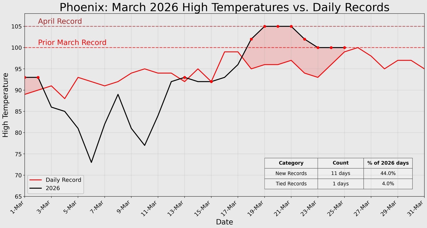
Phoenix Experiences Warmest February and Winter on Record
GaWx replied to donsutherland1's topic in Climate Change
Hey Don, Phoenix had a high of 100 today, the 8th day in a row of 100+! Before 2026, there had been only one March day of 100+ and that was right at 100 on March 26th! Holy cow!


.thumb.png.4150b06c63a21f61052e47a612bf1818.png)