All Activity
- Past hour
-
.thumb.jpg.6a4895b2a43f87359e4e7d04a6fa0d14.jpg)
Central PA Winter 25/26 Discussion and Obs
Yardstickgozinya replied to MAG5035's topic in Upstate New York/Pennsylvania
I'm easy to please. If I can get in a couple mile walk under some mood flakes, it gets chalked up as a win in my book. Yesterday was the first day that my pack took a hard hit. I lost more snow yesterday than all the other days combined since the storm. -
-
Yesterday low of 24, high of 59. This morning low of 40. Looking at the extended forecast, No more 20's for a bit.
-
Last window will be approx 2nd week of March. Have to get CPK to average snowfall at that point hopefully.
-
When they’re on an island this close in, they’re likely wrong.
-
Speaking of twitter…I was thinking how it’s been a tough winter for Fish to troll ACATT, but it’s nice to see him still trying
-
 Well +EPO is usually above. If the vortex over Alaska verifies, we will likely go warmer if not that day then the next few days. Here's the 6z GEFS
 -

Presidents' day Snow potential
NorthShoreWx replied to WeatherGeek2025's topic in New York City Metro
https://www.instagram.com/reel/DEg9tVQPsEN/?igsh=MTdja3R1MG9xNWRiZQ== -
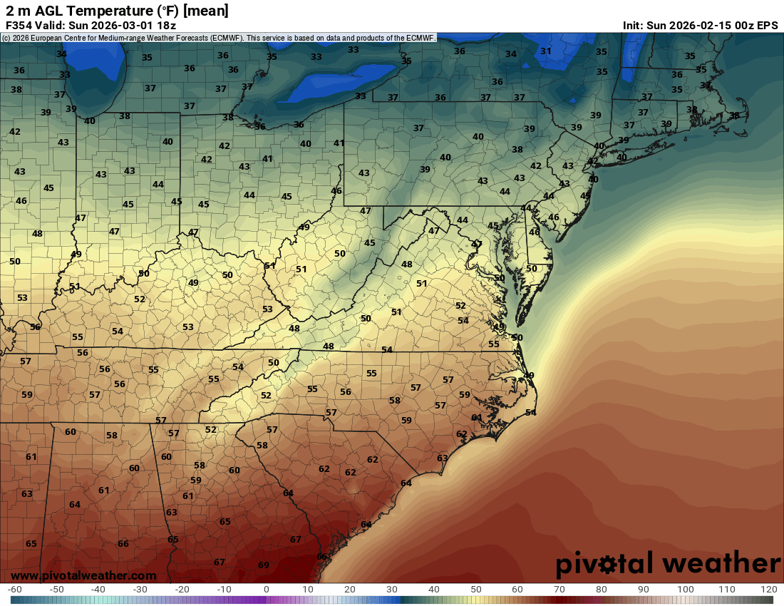
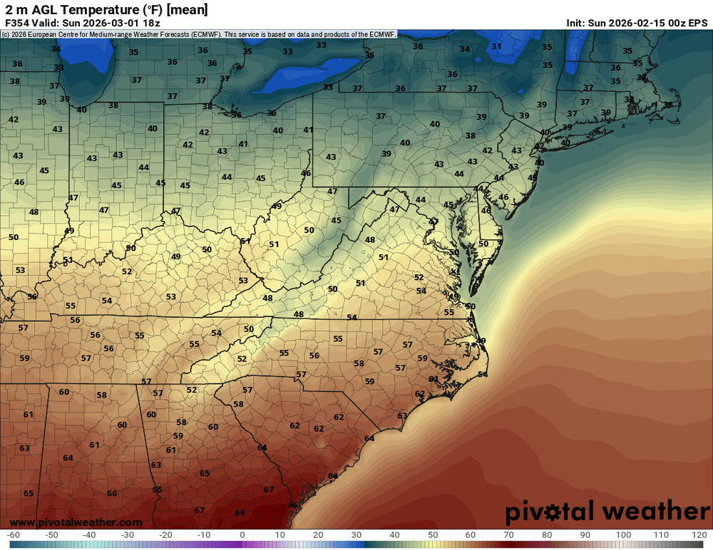
 Barely per attached, but the 348hrs and 360hrs are both slightly below per Pivotal.
.thumb.png.6fce1653733979b9f77ef4a5b5a26a1a.png)
-

Central PA Winter 25/26 Discussion and Obs
mahantango#1 replied to MAG5035's topic in Upstate New York/Pennsylvania
-
I’ve enjoyed his winter playoff beard this season, but hopeully he plans on shaving it with the first 60° day.
-
The trend is toward higher amounts of pure water in the Sierra Sun night thru Thursday. More communities are expected to receive the snow equivalent of ten inches of pure water with about 12 to 1 snow to water ratios, but those ratios could be 14 to 1. Though its true that high winds will knock the accums down some, that's still a fairly Brobdingnagian amount of snow. The specter of eight feet of snow from this is looming for many more Sierran communities. It's going to be a fun storm to watch on webcam, especially during the day. Not so much if you happen to be a tourista caught out in this in a car in high winds and milkshake-like froth visibilities, in single digit cold with wind chills down to negative 40 degrees at times and crazy snow rates.
-
With a biscotti on the side
-

Central PA Winter 25/26 Discussion and Obs
Mount Joy Snowman replied to MAG5035's topic in Upstate New York/Pennsylvania
Low of 28. Looks like the lower level warmth will win out with the column too slow to cool to the surface. Perhaps a slushy half inch on the tail end. Then we finally lose our pack this week. MDT and LNS both topped out at 48 yesterday. Onward. -
Balmy 11 degrees and feels spring Iike. Great weather to haul pellets into the breezeway.
-
..it's Stein
-
PD II updated maps coming next. Oddly, i just check the list of all historic storms i have on the website right now and theres almost nothing from Feb 15th to the end of Feb other than PD2 and 1999/2010 for big ones. Tons in March though.
-
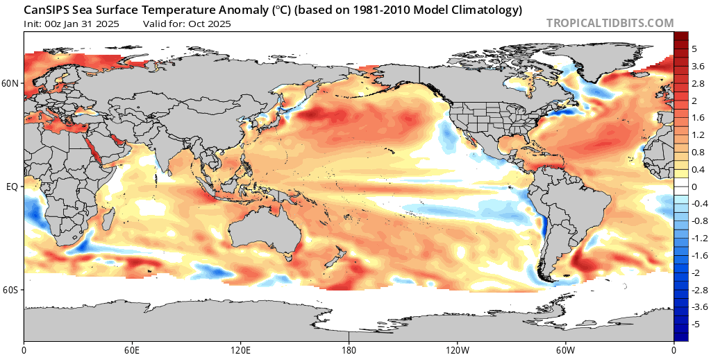
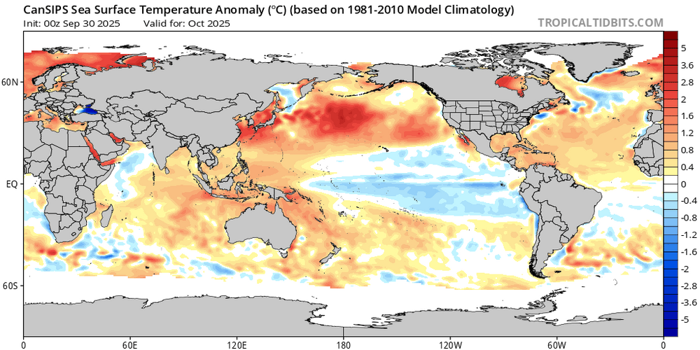
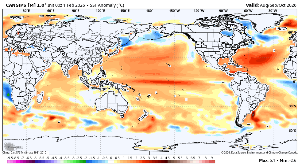
Yesterday’s publicly available Bastardi video (“Saturday Summary”) didn’t at all talk about the upcoming mild E US (gee, I wonder why lol) and instead talked about the expected upcoming El Nino being a Modoki. He’s using CANSIPS SSTAs to predict that, which I feel is wrought with risk as it similarly predicted a Modoki El Niño for this past autumn last year at this time: What verified per this same model? A redeveloping La Niña: look how far off CANSIPS was! Here’s CANSIPS trying again for Modoki El Niño next autumn: will it verify this time or will it again bust? Opinions? Based on the following latest CANSIPS prog of ASO SST anoms, which he showed in his video, he’s going all-in on Modoki next hurricane season and continuing through winter: Based on this Modoki prog, JB is going for: -very active and threatening to US 2026 hurricane season using the highest impact on US El Niño seasons of 1969 and 2004 as analogs (which he considers Modoki) along with a very warm Atlantic with ACE of 140-180, 17-21 NS, 8-10 H, 3-5 MH, 1-3 US H landfalls, and 1-2 MH US landfalls -cold winter throughout much of Conus due to limited time spent in warm phases 4-7. He’s saying that 2023-4 was a warm flop only because models were wrong in predicting typical cold around Australia. It ended up warm there and in W Pac in general, which lead to a dominant +WPO instead of the progged -WPO. He said that warmth there was due to the “sudden impact of geothermal a couple of years ago”. He said SST anoms E of Australia rose an unprecedented 5 degrees from Nov to Jan, which he said had nothing to do with CO2 or solar. He expects none of the same as 23-24 this time with W Pac undersea seismic activity down and thus there instead being the typical cold around Australia during El Niño this fall/winter ————— My primary concerns with JB forecast: - Will it actually be Modoki? CANSIPS can’t be trusted for one thing. - 2004 and 1969 were weak Ninos per ONI/RONI. Will 2026-7 actually be a weak Nino? -JB tends to forecast the more threatening H season and cold E US winter scenarios and has even admitted to having a cold bias @snowman19

-
Lol. Maybe even Folgers?
-
He starts every morning pouring that first cup of Maxwell House and then clicks his drought monitor bookmark.
-
Can already hear more birds in the morning now.
-
With all of the stupid things I did in my teens and early 20s, I’ve often said my most successful accomplishment during that time is surviving through it. lol
-
He’s banking on early Spring and endless dry .
-
you rang


.png.756a9014a31cb04cca5ba7d951c7137f.png)