All Activity
- Past hour
-
Lots of cooling near Japen of late.
.png.0e861007bbfffbf1a3daa3e0387c5221.png)
-

2025-2026 ENSO
donsutherland1 replied to 40/70 Benchmark's topic in Weather Forecasting and Discussion
Here's a link: www.jamstec.go.jp/virtualearth/general/en/graph_SINTEX.html#emi -
Could be a little bit of upwelling too. She's been crawling along
-

E PA/NJ/DE Autumn 2025 Obs/Discussion
MGorse replied to PhiEaglesfan712's topic in Philadelphia Region
Hi Paul. We look at all the temperature data we have access to and based on that, the zone/county has to have half or more coverage of temperatures at or below 32F to end the growing season. The growing season is also ended if it is two weeks beyond the median first Fall freeze date and no freeze has occurred. Little plant growth can be expected beyond that date. -
 Contest scoring for Current Count of 13 5 4 and Potential Counts after potential storm 14 _ _ _ _ _ _ _ _ _ _ _ _ _ _ _ _ _ _ _ _ _ _ _ _ _ _ _ _ _ _ errors to date __ points deducted _ TOTAL SCORE Rank _FORECASTER (order of entry)_______TS _ H _ M _ errors (scoring) _ 13 5 4 (alt 14 5 4, 14 6 4, 14 6 5) _01 __ Retrobuc (11) __________________________1 __ 1 _ 1 ___ -0.5_ -1 _ -1 ____97.5 (98, 99, 97) _02 __ StormchaserChuck (23) ______________ 0 __ 2 _ 0 ___ 0 __-3 _ 0 ____ 97 _ (96.5, 98.5, 97.5) _03 __ cardinalland (14) ______________________2 __ 1 _ 1 ___-1.5 _-1 _-1 ____ 96.5 _ (97.5, 98.5, 96.5) _04 __ vpbob21 (19) __________________________2 __ 2 _ 0___-1.5_-3_ 0 _____95.5 _ (96.5, 98.5, 97.5) _05 __ ineedsnow (2) ________________________ 2 __ 2 _ 1___-1.5_-3 _-1 ____ 94.5 _ (95.5, 97.5, 95.5) _06 __ Hotair (26) ____________________________ 2 __ 1 _ 2 __ -1.5 _-1 _-3 ___ 94.5 (93, 91, 88) _07 __ LongBeachSurfFreak (4) ______________ 1 __ 3 _ 0 ___-0.5_ -6 _0 ___ 93.5 _ (94, 97, 96) _08 __ Newman (15) _________________________ 3 __ 2 _ 1___ -3 _-3 _-1 _____ 93 _ (94.5, 96.5, 94.5) _09 __ cnimbus (6) __________________________ 4 __ 2 _ 0___ -5_ -3 _ 0 _____92 _ (94, 96, 95) _10 __ FPizz (9) ______________________________ 4 __ 2 _ 0___ -5_ -3 _ 0 _____92 _ (94, 96, 95) _11 __ LakeNormanStormin (7) _______________ 3 __ 3 _ 0___ -3_ -6 _ 0 ____ 91 _ (92.5, 95.5, 94.5) _12 __ Floydbuster (12) _______________________ 3 __ 3 _ 0___ -3_ -6 _ 0 ____ 91 _ (92.5, 95.5, 94.5) _13 __ WxWatcher007 (25) ___________________ 3 __ 3 _ 0___ -3_ -6 _ 0 ____ 91 _ (92.5, 95.5, 94.5) _14 __ wxdude64 (28) ________________________ 4 __ 2 _ 1___ -5_ -3_ -1 _____ 91 _ (93, 95, 93) ___ NOAA ____________________________________ 3 __ 3 _ 0___ -3_ -6 _ 0 ____ 91 _ (92.5, 95.5, 94.5) _15 __ Kirkcaldy Weather (NW-6) _____________ 1 __ 4 _ 0 ___-0.5_-10_ 0 ___ 89.5 (88.5, 92.5, 91.5) _16 __ BarryStantonGBP (1) ___________________ 4 __ 3 _ 0___ -5_ -6_ 0 ____ 89 _ (91, 94, 93) _17 __ wxallannj (21) __________________________ 4 __ 3 _ 0___ -5_ -6_ 0 ____ 89 _ (91, 94, 93) _18 __ jmearroz (31) __________________________ 4 __ 3 _ 0 ___ -5_ -6_ 0 ____ 89 _ (91, 94, 93) _19 __ George BM (35) ________________________4 __ 3 _ 0 ___ -5_ -6_ 0 ____ 89 _ (91, 94, 93) _20 __ Kaari (NW-7) ___________________________4 __ 3 _ 0 ___ -5_ -6_ 0 ____ 89 _ (91, 94, 93) _21 __ marsman (14) __________________________ 6 __ 0 _ 1___-10.5 _ 0 _-1____88.5 _ (91.5, 90.5, 88.5) _22 __ Ga Wx (20) ____________________________ 1 __ 4 _ 1 ___-0.5_-10 _-1___ 88.5 _ (89, 93, 91) _23 __ Normandy Ho (30) ____________________ 4 __ 3 _ 1___ -5_ -6_ -1 ____ 88 _ (90, 93, 94) _24 __ BKViking (29) _________________________ 3 __ 4 _ 0___ -3_-10_ 0 ____ 87 _ (88.5, 92.5, 91.5) ___ UKMO ____________________________________ 3 __ 4 _ 0___ -3_-10_ 0 ____ 87 _ (88.5, 92.5, 91.5) _25 __ jconsor (3) ____________________________ 3 __ 4 _ 1___ -3_-10_-1 ____ 86 _ (87.5, 91.5, 92.5) _26 __ Torch Tiger (17) _______________________ 4 __ 4 _ 0___ -5_-10_ 0 ____ 85 _ (87, 91, 90) _27 __ yoda (22) ______________________________ 4 __ 4 _ 0___ -5_-10_ 0 ____ 85 _ (87, 91, 90) ___ consensus __ (median) ____________________ 4 __ 4 _ 0___ -5_-10_ 0 ____ 85 _ (87, 91, 90) _28 __ NeffsvilleWx (10) _______________________ 6 __ 3 _ 1___-10.5_-6_-1 ___ 82.5_ (85.5, 88.5, 89.5) _29 __ Yanksfan (8) ____________________________5 __ 4 _ 0___-7.5_-10_ 0 ___ 82.5 _ (85, 89, 88) _30 __ nvck (32) _______________________________ 5 __ 4 _ 0___-7.5_-10_ 0 ___ 82.5 _ (85, 89, 88) _31 __ NC USGS^ (33) __________________________ 1 __ 5 _ 2 ___-0.5_-15_-3 ___ 81.5 _ (82, 87, 84) _32 __ hudsonvalley21 (34) ____________________ 5 __ 4 _ 1___-7.5_-10_-1 ____ 81.5 _ (84, 88, 89) _33 __ Rhino16 (24) ____________________________ 5 __ 5 _ 0___-7.5_-15_ 0 ___ 77.5 _ (80, 85, 84) _34 __ ldub23 (5) ______________________________ 5 __ 5 _ 1___-7.5_-15_-1 ___ 76.5 _ (79, 84, 85) _35 __ Midlands Ice Age (NW-2, 14) ___________ 5 __ 5 _ 1___-7.5_-15_ -1 ___ 76.5 _ (79, 84, 82) _36 __ The Tall Weatherman (NW-5) __________ 7 __ 4 _ 1___-14 _-10 _-1 ___ 75 _ (78.5, 82.5, 83.5) _37 __ Tallis Rockwell (18) _____________________ 4 __ 6 _ 1___ -5_-21 _-1 ____ 73 _ (75, 81, 82) _38 __ CHSVol (13) ____________________________ 7 __ 5 _ 0___-14 _-15_ 0 ___ 71 _ (74.5, 79.5, 78.5) _39 __ Metwatch (NW-1, 13) ___________________ 8 __ 5 _ 0 __-18 _-15 _ 0 ___ 67 _ (71, 76, 75) _40 __ WYorksWeather (NW-4) ________________4 __ 7 _ 2___ -5_-28 _-3 ___ 64 _ (66, 73, 75) _41 __ Roger Smith (27) ________________________7 __ 6 _ 1___-14 _-21 _ -1 ___64 _ (67.5, 73.5, 71.5) _42 __ matty40s (NW-3) ______________________ 9 __ 6 _ 2 __-22.5_-21_-3__ 53.5 _ (58, 64, 66) ================= (errors in red are forecasts already passed by actual count; these errors can increase) (three alternate scores are for potential named storm 14, for outcomes of only TS, only H, and MH) (order of entry breaks ties in total score) mean now required (excl expert fcsts) is 3.8 _ 2.3 _ 0.0 = 100 -4.5 -3.8 -0 = 91.7 _ (93.6, 96.1, 95.1) ^ ... NC US Geological Survice is full user i.d.
 -

Spooky Season (October Disco Thread)
jbenedet replied to Prismshine Productions's topic in New England
Still a ton of run to run changes happening across guidance inside 3 days out on the large scale mid level features. -
.thumb.png.4150b06c63a21f61052e47a612bf1818.png)
Spooky Season (October Disco Thread)
HIPPYVALLEY replied to Prismshine Productions's topic in New England
I mean, you’re not wrong. -
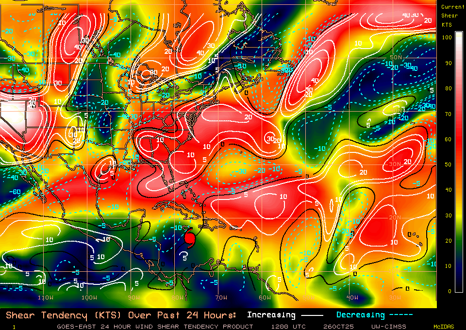
The shear to the West, Northwest has been steadily decreasing. Strengthening should resume later today.
-
Yeah I don’t think there was any reason to take the winds down, especially when the forecast is for 140kt 24 hours from now.
-

Spooky Season (October Disco Thread)
WxWatcher007 replied to Prismshine Productions's topic in New England
The first time we go through the ole epic pattern to cutter cycle in December, we’ll see quite a show. -

Spooky Season (October Disco Thread)
Snowcrazed71 replied to Prismshine Productions's topic in New England
And where might I ask are you coming up with that forecast? -
Yeah, it was first at 10:54AM. All of it was later vs average release time.
-
Hurricane Melissa Discussion Number 21 NWS National Hurricane Center Miami FL AL132025 1100 AM EDT Sun Oct 26 2025 After rapidly intensifying over the past day or so, NOAA-P3 aircraft data indicates that Melissa's intensity has leveled off this morning. Melissa remains a very formidable hurricane on satellite imagery, with a clearing eye quite evident on morning visible imagery, and the eye temperature has warmed to +15-20C. Meanwhile the eyewall convection continues to remain robust with cloud tops as low as -75 to -80C encircling the core. With that said, the eye presentation from the Kingston, Jamaica radar is not as pristine, with the eyewall occasionally open on the east side, and some evidence of concentric bands forming off and on. Zooming out a bit, there still remains some evidence of light to moderate westerly shear undercutting the expanding storm outflow, and Melissa’s primarily rainbands are distributed mostly on the eastern side of the circulation. NOAA-P3 aircraft data this morning had a peak 700- mb flight level wind of 120 kt, and Tail Doppler Radar (TDR) wind retrievals were up to 129 kt at 0.5 km, and 129 kt in the 500 m average of a dropsonde launched in the north eyewall. While this data would support a somewhat lower intensity, the subjective and objective satellite based intensity estimates are mostly higher, ranging from 115 to 140 kt. The initial intensity will be held at 120 kt, on the lower end of those estimates, and this value could be a little generous based on the aircraft data. The major hurricane is moving westward this morning, from aircraft fixes estimated at 270/3 kt. This motion is expected to continue for the next 24-36 h as a narrow mid-level ridge to the north of Melissa imparts the majority of the steering. Thereafter, a short-wave trough moving into the southeastern United States is expected to erode this ridge, allowing Melissa to turn sharply to the northeast, with gradual acceleration. On the forecast track, Melissa's core is expected to be near the Jamaica coastline by Tuesday morning, moving across the island and then approaching and moving over eastern Cuba by Tuesday night. While the track guidance has become tightly clustered over the first 24-48 hours, the along-track spread starts to increase significantly after that time period, with Google DeepMind ensemble solutions on Wednesday morning ranging from between Jamaica and eastern Cuba in the Caribbean Sea, over eastern Cuba, or in the Southwestern Atlantic near the Southeastern Bahamas and Turks and Cacaos Islands. The latest NHC track forecast was nudged just a little westward of the prior track, once again blending the reliable track aids HFIP Corrected Consensus Approach (HCCA), and Google DeepMind ensemble mean (GDMI). It is unclear if the current pause in Melissa's intensification is temporary. While there have not been obvious indications of a secondary eyewall formation yet, there are some concentric reflectivity bands appearing on both Jamaica and NOAA-P3 TDR data occasionally, though the inner eyewall remains strong. Some of the guidance this morning has actually increased from yesterday at this time, and notably both the HAFS-A/B explicitly forecast a Category 5 hurricane shortly before they show landfall in Jamaica. The latest NHC intensity forecast will continue to show a peak intensity of 140 kt. However, inner-core fluctuations like eyewall replacement cycles could occur at any time. Regardless, Melissa is forecast to reach Jamaica as an upper-end category 4 hurricane, which will only exacerbate any damages caused by heavy rainfall and flooding over the next 2 days. Melissa will likely weaken some as it traverses over the higher terrain of Jamaica, but it is still forecast to be a major hurricane when it subsequently moves over eastern Cuba in 60-72 hours. Thereafter, increasing southwesterly shear should cause gradual weakening, but Melissa could still be near hurricane intensity when it makes it closest approach to Bermuda in about 5 days. The latest NHC intensity forecast is on the high end of the intensity guidance, but not far off the GDMI, and HAFS-A/B intensity aids. Key Messages: 1. Jamaica: Seek shelter now. Damaging winds and heavy rainfall today and Monday will cause catastrophic and life-threatening flash flooding and numerous landslides before potentially devastating winds arrive Monday night and Tuesday morning. Extensive infrastructural damage, long-duration power and communication outages, and isolation of communities are expected. Life-threatening storm surge is likely along portions of the southern coast Monday night and Tuesday morning. 2. Haiti: Catastrophic and life-threatening flash flooding and landslides are expected across southwestern Haiti through midweek, likely causing extensive infrastructural damage and isolation of communities. Although winds are temporarily decreasing on the Tiburon peninsula, they could increase again across much of western Haiti on Tuesday. 3. Dominican Republic: Heavy rainfall through midweek could produce catastrophic flash flooding and numerous landslides in southern portions of the country. 4. Eastern Cuba, Southeast Bahamas, and the Turks and Caicos: Monitor Melissa closely. There is an increasing risk of a significant storm surge, damaging winds, and heavy rainfall Tuesday and Wednesday. In eastern Cuba, the risk of life-threatening flash flooding and landslides is increasing. A Hurricane Watch is in effect for portions of eastern Cuba. FORECAST POSITIONS AND MAX WINDS INIT 26/1500Z 16.4N 76.6W 120 KT 140 MPH 12H 27/0000Z 16.4N 77.1W 130 KT 150 MPH 24H 27/1200Z 16.6N 77.8W 140 KT 160 MPH 36H 28/0000Z 16.9N 78.0W 140 KT 160 MPH 48H 28/1200Z 17.8N 77.7W 135 KT 155 MPH 60H 29/0000Z 19.2N 76.6W 110 KT 125 MPH 72H 29/1200Z 20.9N 75.1W 95 KT 110 MPH 96H 30/1200Z 25.5N 71.0W 85 KT 100 MPH 120H 31/1200Z 32.0N 65.5W 75 KT 85 MPH $$ Forecaster Papin
-
The forecast advisory was out earlier
-
That wasn’t released til 10:56 AM EDT. That’s very late for the 11AM. And discussion still wasn’t out yet. It wasn’t released til 10:59AM!
-
- Today
-
Still 140mph at 11... 953mb BULLETIN Hurricane Melissa Advisory Number 21 NWS National Hurricane Center Miami FL AL132025 1100 AM EDT Sun Oct 26 2025 ...MAJOR HURRICANE MELISSA CONTINUES SLOWLY WESTWARD WITH LITTLE CHANGE IN STRENGTH... ...LIFE-THREATENING AND CATASTROPHIC FLASH FLOODING AND LANDSLIDES EXPECTED IN PORTIONS OF JAMAICA AND SOUTHERN HISPANIOLA THROUGH MIDWEEK... SUMMARY OF 1100 AM EDT...1500 UTC...INFORMATION ----------------------------------------------- LOCATION...16.4N 76.6W ABOUT 110 MI...180 KM S OF KINGSTON JAMAICA ABOUT 280 MI...445 KM SSW OF GUANTANAMO CUBA MAXIMUM SUSTAINED WINDS...140 MPH...220 KM/H PRESENT MOVEMENT...W OR 270 DEGREES AT 3 MPH...6 KM/H MINIMUM CENTRAL PRESSURE...953 MB...28.15 INCHES
-
There was only 39 ACE through Sept 16th. There has been 67 ACE Sept 17th through 12Z today with likely 20+ more to come from Melissa, alone. This heavy late season vs earlier has been more common in recent years, especially during La Niña.
-

Spooky Season (October Disco Thread)
powderfreak replied to Prismshine Productions's topic in New England
Haha, I appreciate you staying on brand. There could be 500 million acres of lava in the Arctic and the answer would be “let’s see if it’s still burning in a week, we just don’t know what’ll happen.” -

Spooky Season (October Disco Thread)
WinterWolf replied to Prismshine Productions's topic in New England
Lol, worrying about an ice free arctic, and puke pacific air on 10/26…what Foolish talk. Gorgeous autumn weather..that is perfectly seasonal…that’s the good news. -
My Mandevilla vine is covered in flowers now. Might bring it inside by the end of the week though.
-
I dunno’ he seems to take long breaks outside of the winter season.
-
(002).thumb.png.6e3d9d46bca5fe41aab7a74871dd8af8.png)
E PA/NJ/DE Autumn 2025 Obs/Discussion
ChescoWx replied to PhiEaglesfan712's topic in Philadelphia Region
Hi Mike, Hope all is well! How does Mt.Holly determine the end of the growing season and when to stop issuing frost advisories for a county or zone? Here in Chester County it is tough as most spots below 550 feet have had multiple freezing days and frosts already this month. However, higher spots like around my area we have seen no frosts or freezes. Thanks! Paul -
I've sensed this for a long time, it's a big part of what drew me to read your work years ago and keeps me following you. Thanks for the good work
-
Spooky Season (October Disco Thread)
HIPPYVALLEY replied to Prismshine Productions's topic in New England
The ‘ ‘s look like they’re going to come early and often this year.


