All Activity
- Past hour
-

Central PA Winter 25/26 Discussion and Obs
Blizzard of 93 replied to MAG5035's topic in Upstate New York/Pennsylvania
Or just ignore the worthless ICON? -

Possible Record Breaking Cold + Snow Sunday 1/25 - Tuesday 1/27
MJO812 replied to TriPol's topic in New York City Metro
6-12 inches with sleet will make the snow concrete and cause a mess. The snow will not go anywhere next week with the frigid temps. Then we have to see if we get another snowstorm next weekend. -
But the thing is, it isn't. Any storm like this has the same odds to uptrend or downtrend regardless of ENSO state. It just doesn't matter in this small of a timeframe.
-

Central PA Winter 25/26 Discussion and Obs
pasnownut replied to MAG5035's topic in Upstate New York/Pennsylvania
Will GFS keep hopes and dreams alive.....?? Here we go. -
.thumb.png.4150b06c63a21f61052e47a612bf1818.png)
“Cory’s in LA! Let’s MECS!” Jan. 24-26 Disco
HIPPYVALLEY replied to TheSnowman's topic in New England
Less than true E -> W fetch. -

MO/KS/AR/OK 2025-2026 Winter Discussion
MoWeatherguy replied to stormdragonwx's topic in Central/Western States
Is this crap really real or are the models just all reading something wrong?? -
Not tonight. The US is holding on to all the recon data to make us look good.
-

Pittsburgh/Western PA WINTER ‘25/‘26
TimB replied to Burghblizz's topic in Upstate New York/Pennsylvania
And we know what happens. Does the WTOD ever just stop at the Mason-Dixon? (Rhetorical question) -

January 24-26: Miracle or Mirage JV/Banter Thread!
Wxtrix replied to SnowenOutThere's topic in Mid Atlantic
-

January 24-26: Miracle or Mirage JV/Banter Thread!
stormtracker replied to SnowenOutThere's topic in Mid Atlantic
We really don't do shifts. I know they pay closer attention during big events and are generally just around. I usually don't moderate because I'm terrible at it and I'm just as bad as anybody else. -

“Cory’s in LA! Let’s MECS!” Jan. 24-26 Disco
40/70 Benchmark replied to TheSnowman's topic in New England
Will, where is Jan 7, 2024 track?? I assume it was between the islands and BM? -

Pittsburgh/Western PA WINTER ‘25/‘26
Burghblizz replied to Burghblizz's topic in Upstate New York/Pennsylvania
Isn’t that like a next gen rapid refresh model? I would think that would have a warm bias in this range. -
 GFS ROLLING
 -
Central PA Winter 25/26 Discussion and Obs
pasnownut replied to MAG5035's topic in Upstate New York/Pennsylvania
2m temps notably colder, so lets hope future runs latch onto CAD to mitigate pinger intrusion for lsv. Thats a 50/50 blend of wishcasting and what 2m temps show. -

January 24-26: Miracle or Mirage JV/Banter Thread!
LordBaltimore replied to SnowenOutThere's topic in Mid Atlantic
2-4 inches of sleet guy knew what's up -
Depends on if surface temps stay above freezing or dip down below.
-

January 25/26 Jimbo Back Surgery Storm
NorthHillsWx replied to Jimbo!'s topic in Southeastern States
I will say this, ICON and NAM ticked pretty far north with main moisture feed. If that shows up on other modeling the severity of this goes way way down. Freezing drizzle sucks but it doesn’t get you to damaging ice -

January 24-26: Miracle or Mirage JV/Banter Thread!
Nomz replied to SnowenOutThere's topic in Mid Atlantic
Look at my location. First winter away from Boston for college. Debating between wanting this to stay as it is so we can get some good thump, and hoping for it shoot way north so I don't have to see pictures of home covered in 24" -
Absolutely incredible. Up to 7.5” two day total. 6.2” today. Snow depth over 18”. Amazing day.
-
Lol Not quite what I mean. If you track a storm in a nina, ya gotta lower your expectations even more because nina crap is more likely to get in the way and mess it up. I mean look where we are right now...
-
“Cory’s in LA! Let’s MECS!” Jan. 24-26 Disco
HIPPYVALLEY replied to TheSnowman's topic in New England
It's every model for itself right now wrt mby! -
January 24-26: Miracle or Mirage JV/Banter Thread!
stormtracker replied to SnowenOutThere's topic in Mid Atlantic
Fucking nerds -

Pittsburgh/Western PA WINTER ‘25/‘26
MikeB_01 replied to Burghblizz's topic in Upstate New York/Pennsylvania
is the new sampled data going to be in the fresh GFS and Euro runs again tonight? -

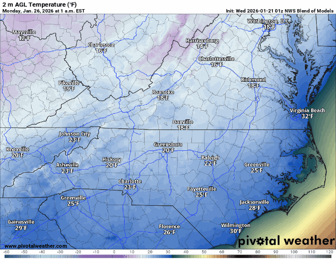
January 25/26 Jimbo Back Surgery Storm
Leesville Wx Hawk replied to Jimbo!'s topic in Southeastern States
WRAL all in with ice storm at roughly 0.6” accrued . There wasn’t any mention of sleet that I heard. Am I missing something here? They are going strictly in-house and European from what I can tell. One would think that they could at least mention that sleet could partially save the day for much of central NC as depicted by NAM and GFS. Maybe they are right but it seems a bit early to be certain. . -
Same question, but 1 AM Monday. Trend appears to be consistent. Two more days of the models "warming" and I don't see how we end up with the same ice that is currently being forecasted.