All Activity
- Past hour
-
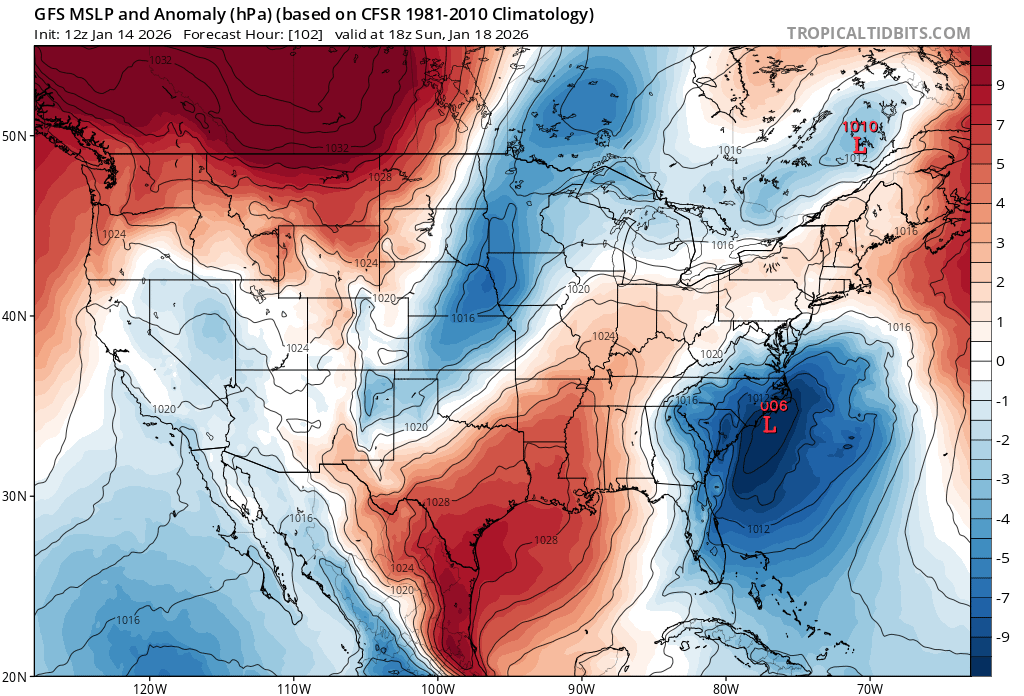
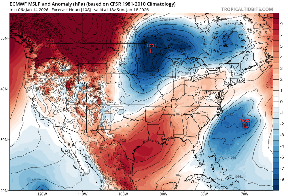
The GDPS shows 3 separate periods of snow - including weekend, daytime snow! It ends up as a fairly long duration light event with moderate snow accumulations region-wide. I like that outcome a lot. The GFS shows a high-end threat. That's a beautiful coastal storm evolution with NESIS potential. Things have been trending better for 2 days, but we might have reached the end of the trend. The UK backed off and the GEFS individuals are all east of and weaker than the GFS SLP except one weaker member near ELI. You could argue it both ways, but I prefer not seeing the OP GFS west of the ensemble spread. That's a red flag.
-

January 2026 Short/Medium Range Thread
Holston_River_Rambler replied to John1122's topic in Tennessee Valley
There is satellite imagery on it: -
As you mentioned re the reading out in Reno, that is an extremely pumped ridge. Just need orientation and depth around the Mississippi and there could be something real.
-
Scroll up and see what SnowGoose said about that.
-
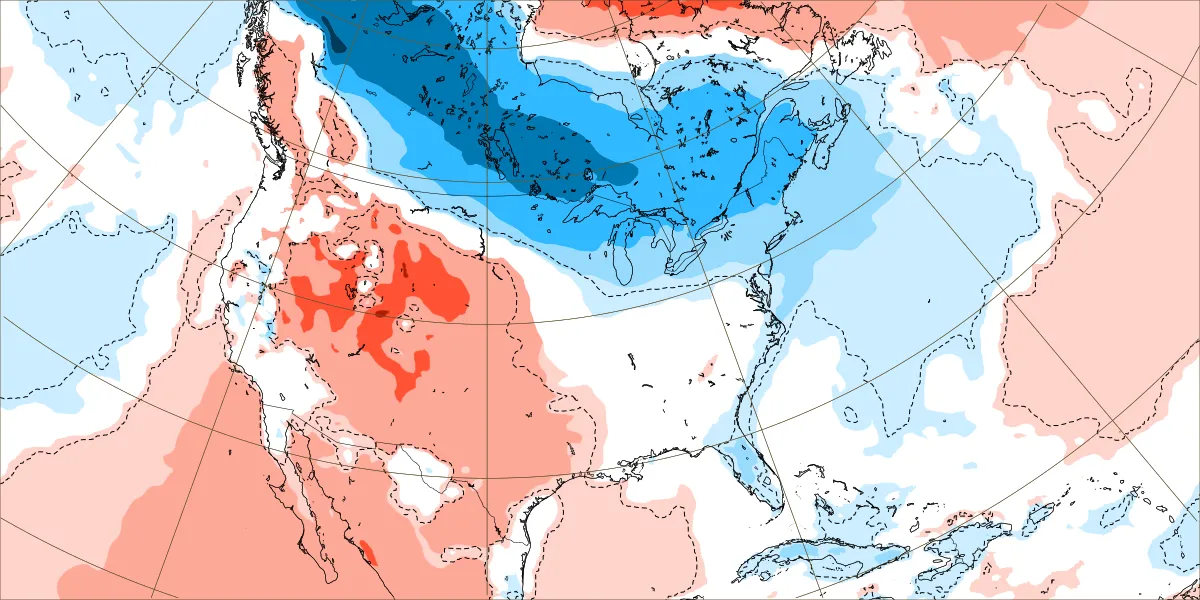
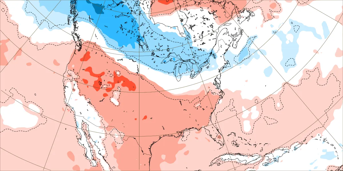
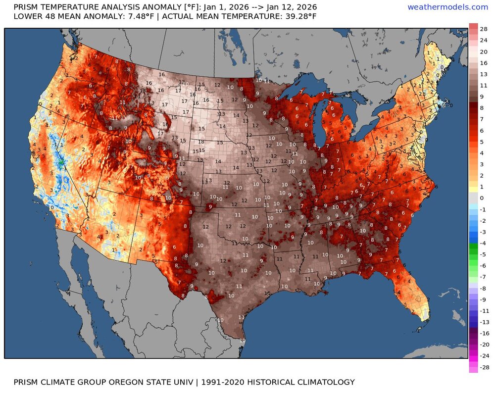
Yeah, numerous spots out West and in the Plains are over +10 so far. This was a pretty big miss from the model forecasts issued around Christmas. They were much too cold for the warmer pattern which verified. EPS forecasts from 12-25-25 Dec 29 to January 5th Jan 5 to 12


-
Clear west trend on the Canadian
-

January 2026 Medium/Long Range Discussion
MDScienceTeacher replied to snowfan's topic in Mid Atlantic
What the GFS is showing right now.. especially how it compares to the Euro and how far our we are and the recent trends seems awfully familiar. I am trying really hard not to be negative.. but we need I swear I have seen this same thing play out like 30 times before. Its almost as if the GFS has a in tendency to over do trends in medium range and then correct back as we move toward game time. I hope I am wrong.. and we finally win one! -
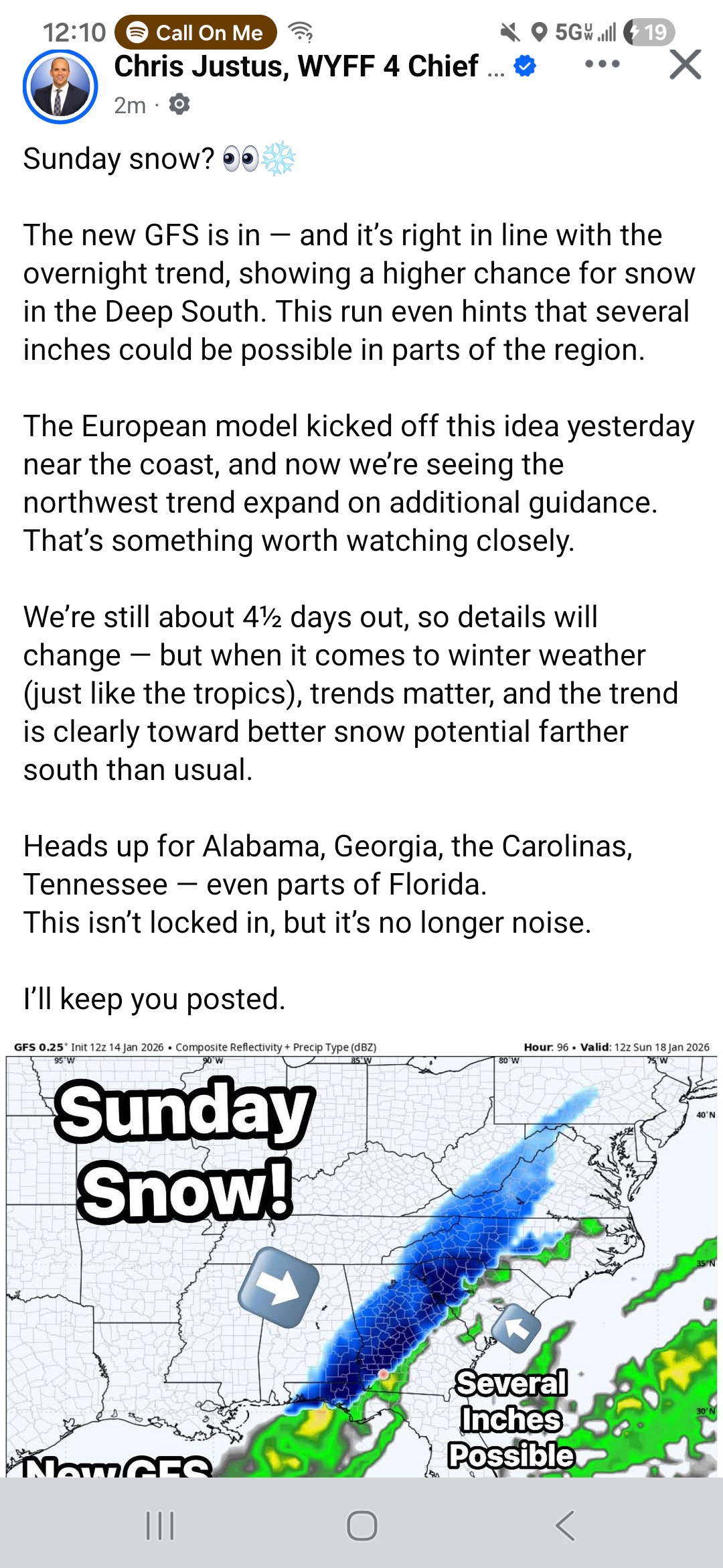
I love Chris J... I do, hes a great dude and a snow weenie. But man posting that on FB is dangerous.... the average person isn't reading all that theyre just seeing the pic and running with it.

-

January 2026 regional war/obs/disco thread
Sey-Mour Snow replied to Baroclinic Zone's topic in New England
rev is that you? -

January 2026 Medium/Long Range Discussion
SomeguyfromTakomaPark replied to snowfan's topic in Mid Atlantic
Just looking at the Euro since 12z yesterday it has trended closer to the coast by about 225 miles. We will need at least that much additional adjustment to score. I'm hoping for it all at once at 12z. -
Clear west trend on the Canadian
-
Maintain the view of a more active southern stream with cold air nosing into the northern tier and potentially into the midcon. MLK weekend is the start of our best pattern potential for higher impact snow storms in quite some time. Pieces are on the board, it's a matter of putting them together.
-
January 2026 Short/Medium Range Thread
Holston_River_Rambler replied to John1122's topic in Tennessee Valley
With regards to Sunday, our shortwave is near the North Pole right now and will have a rather complicated evolution: Using the 6z Euro as a neutral example: Starting location: Complicated evolution: -

Appreciating Each Other/Poster Compliments
dailylurker replied to SnowenOutThere's topic in Mid Atlantic
We work as a team. You'll be seeing me as well lol. Katabatic is a great guy. We had a blast on our last chase. He's become a lifelong friend. I look forward to you joining us at Snow Camp! I like everyone here. I even really like JI. I'd let him join me on a chase. No complaining on the Tug Hill though lol -

Appreciating Each Other/Poster Compliments
DanTheMan replied to SnowenOutThere's topic in Mid Atlantic
Love this. Just wanted to say I appreciate everyone for fueling my hobby and helping me learn new things all the time. Biggest thank you to the red-taggers who take time from their busy schedules to contribute here! -
GFS is shades of the often forgotten January 2018 coastal blizzard. Close to 2 feet and hours of legit blizzard conditions in Point Pleasant Beach that day.

-
I'm genuinely surprised that I've been mentioned here. Thought I provided nothing but here we are. Today I'll be thanking @SnowenOutThere. Firstly, thank you for creating this thread. This forum definitely needs something like this, and maybe the other subforums can take a hint from this. Secondly, I would like to applaud you for your amazing posts. You're a top 5 poster IMO. The quality has improved rapidly, and whenever you post I learn a lot from you. And lastly, thank you for being so supportive of me by putting up with my BS. It's really helped me to find a place in this forum.
-
Back in the olden days, didn’t the UK sort of hint at where the EURO was going to end up on its next run? I feel like I remember folks making those connections back in 2014-2018 when we were tracking storms left and right
-
The GFS has been on a heater with digital snow recently
-
Let’s use this for all these chances of snow between now and Saturday. My mental summary: 16th: maybe rain ends as brief snow? 17th: GFS has a dusting for metro corridor? 18th: GGEM/RGEM and Ukie have shovelable snow, mostly for Maryland
-
Yeah, some big differences in surface low location to resolve. Unclear if along 85 or the coastal plain will be the spot to be just yet
-
Hate that we lost the UK but if the Euro jumps on board then its game on.
-

January 2026 regional war/obs/disco thread
GCWarrior replied to Baroclinic Zone's topic in New England
Canadian has it. -
God gfs is such a weenie model
-
Going to modify the useless thread for tonight into a combo Thursday-Saturday thread