All Activity
- Past hour
-
 Might not get out of the 30s on Tuesday here.
 -

Mid to long range discussion- 2025
WinstonSalemArlington replied to wncsnow's topic in Southeastern States
Historic Florida cold -
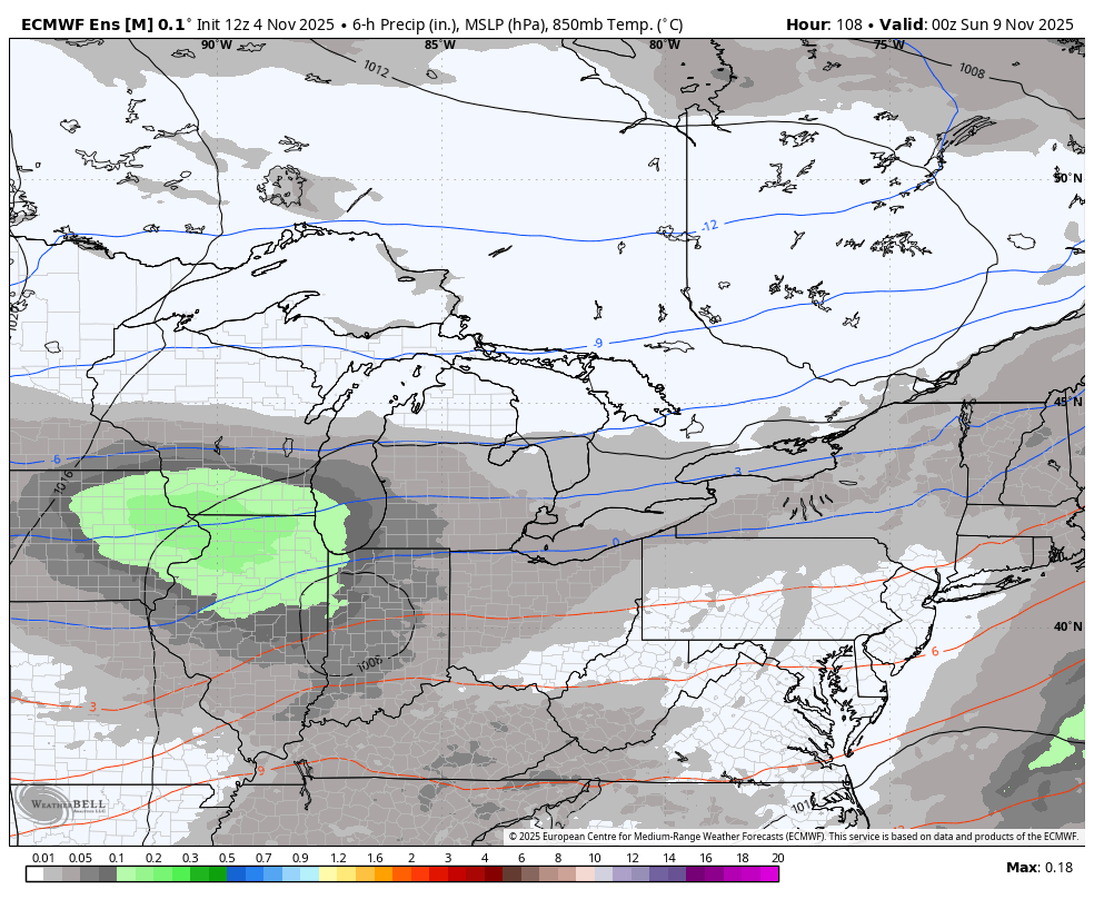
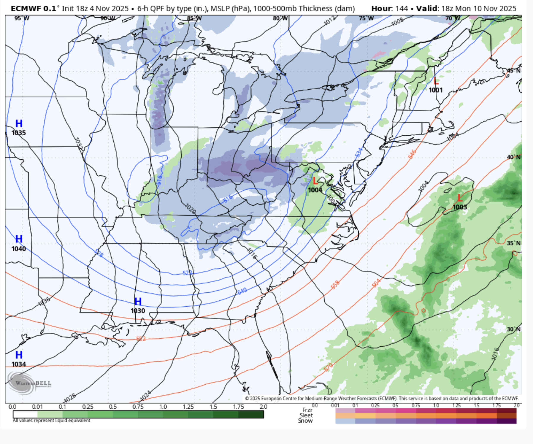
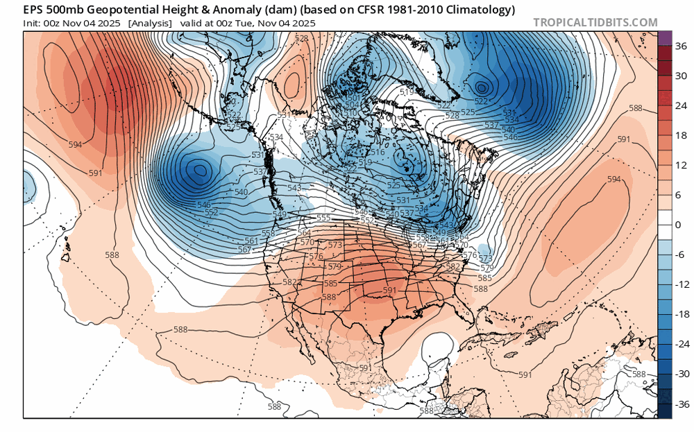
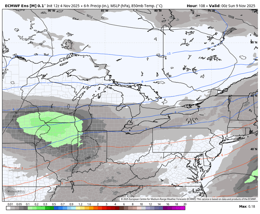
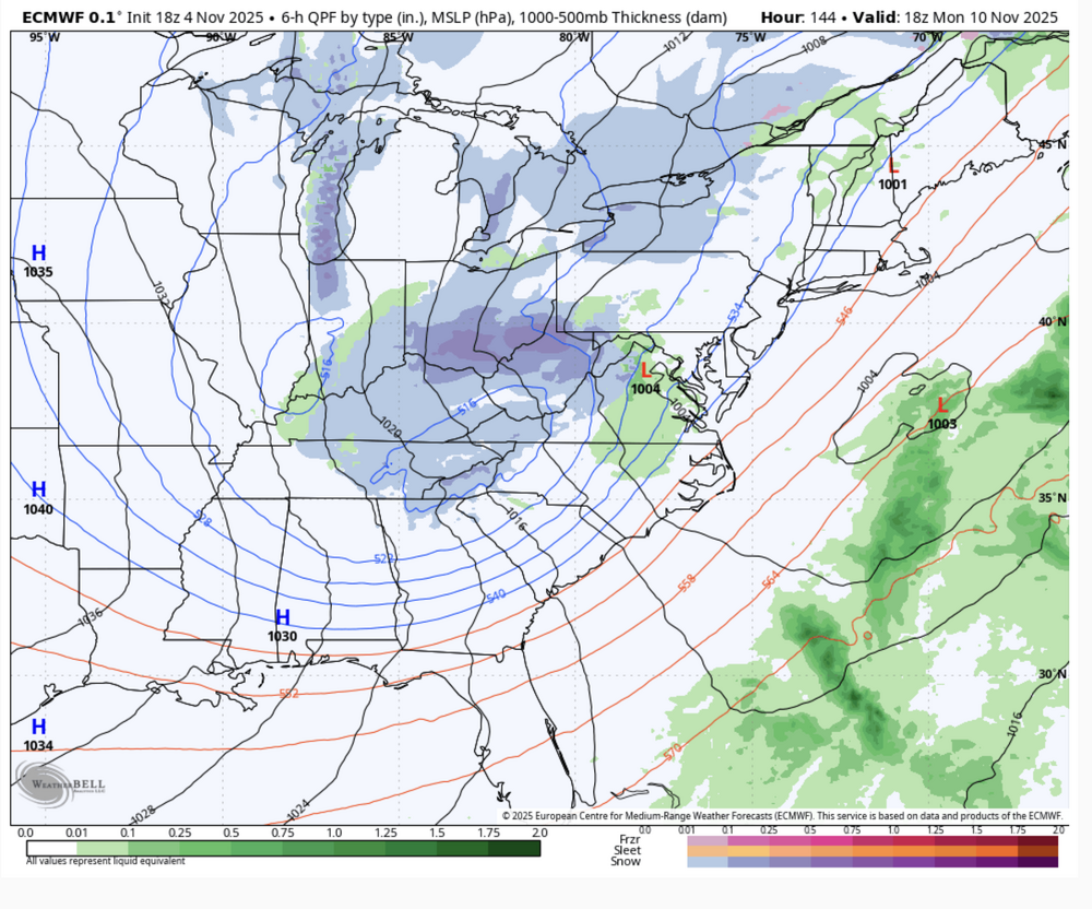
At this point, I am definitely "in" on accumulating snow somewhere across the snowbelt to start next week. It is short lived, but there will be a nice pattern amplification this weekend into the beginning of next week. That will send a chunk of the PV currently up over the arctic circle south into the Great Lakes Sunday and Monday: While details are of course going back and forth on the latest deterministic model runs as they will at this range, the ensemble mean SLP, 850mb temperature, and QPF loop is a pretty good look for lake effect: There may be some wet snow with that little wave of low pressure on Sunday depending on where it tracks...however, the lake effect ramps up behind it Sunday night into Monday, and probably lingers into Tuesday before ridging and warm air advection really start kicking in. Ensemble mean 850mb temps are down around -9C on Monday, with the ensemble mean depicting nice cyclonic flow across the Great Lakes and suggesting a more west to northwest wind direction. 500mb temperatures are progged to bottom out between -35 and -40C over a lake that is currently about 12C, which suggests very strong and deep instability is in play, potentially enough for thunder and lightning. We'll need to see how the specifics evolve as it gets closer, but the ingredients are there for a (somewhat brief) period of intense lake effect centered around Monday of next week, and the airmass should be cold enough for accumulating snow if we're able to get any sort of organized activity...which seems likely.
-
How far out is 18z? Sorry newb! .
-

Fall 2025 Medium/Long Range Discussion
OHweather replied to Chicago Storm's topic in Lakes/Ohio Valley
It doesn't last long because the Pacific is moving way too fast right now, but a nice pattern amplification this weekend into the beginning of next week. You can see the chunk of the PV at the beginning of the loop up in the middle of the arctic circle that drops towards Hudson Bay this week and gets pulled into the Great Lakes and New England Sunday through Tuesday. It will be impressively cold aloft beneath this, so the lakes will be cranking. Pretty good chance that there's enough snow to prompt at least winter wx advisories off a few of the lakes, usually when it's as cold aloft at 500mb as what the models are depicting and the lakes are this warm there are some intense bands.
-
 Little faith this far out......but it's still nice to see the words. Monday A 50 percent chance of rain. Partly sunny, with a high near 51. Monday Night A chance of rain and snow. Mostly cloudy, with a low around 26. Chance of precipitation is 30%. Veterans Day A 30 percent chance of snow. Mostly sunny, with a high near 42.
 -

November 2025 general discussions and probable topic derailings ...
kdxken replied to Typhoon Tip's topic in New England
"The biggest event of my life was the July 2012 microburst that went through my yard. Instant whiteout, 80 mph gusts if I had to guess, and nickle sized hail" Those are the ones you remember. Short-lived, isolated, and intense. Happened to me when my daughter was an infant. Must have been 1994. Unclipping her car seat and heading into the store and said maybe I better wait this one out. All hell broke loose. Kind of like December 2005 although that wasn't that isolated. - Today
-
 Unless the big wind knocks them down tomorrow night., next week it is
 -

Central PA Fall Discussions and Obs
WmsptWx replied to ChescoWx's topic in Upstate New York/Pennsylvania
Holy Hell. The warm milk crowd is having trouble sleeping? The entire "The Joy of Painting" series is on YouTube. It's located here: I fall asleep to this selection every single night. And I am NOT kidding. Good night. -

Overnight Wednesday, November 5, 2025 Wind Event
ChangeofSeasonsWX replied to weatherwiz's topic in New England
The biggest non-tropical wind event for my particular area that I remember was March 2, 2018. The difference with that event is that the wind was sustained, not just in gusts like it usually is. It roared all day into the night and I believe that one had a sting jet also. -
Unless the funnel was visible from imby then it might as well have been in Kansas. lol And six is a big exaggeration. As a matter of fact I don't think Seekonk has had any tornadoes that I know of. A few towns around me have but like I said I never witnessed it personally. The biggest event of my life was the July 2012 microburst that went through my yard. Instant whiteout, 80 mph gusts if I had to guess, and nickle sized hail. That was wild but still has nothing on a hurricane or tornado.
-
Interesting indeed!
-

November 2025 general discussions and probable topic derailings ...
dendrite replied to Typhoon Tip's topic in New England
Might be toast this Fri AM. -
Not that I believe it (yet) but the Euro had NYC itself below freezing next Tuesday morning.
-
Pepper plants look to be on borrowed time now . Likely gone Monday night next week . What a run though May 6- Nov 10th
-
He pretty much said the same thing last year lol. Hopefully Elias has been given an ultimatum this time- spend the fucking money and make this team a winner baby.
-
Tomorrow will be a mild day with highs reaching the lower 60s. A weak cold front could touch off a few scattered showers. It will turn increasingly windy following the frontal passage. Winds will likely gust past 50 mph for several hours. Highs will then fall back to the lower and middle 50s Thursday and Friday before milder conditions return for the weekend. Afterward, there is the potential for a short but sharp cold shot, possibly preceded by a chilly rain. Lows would fall well into the 30s in New York City while highs struggle to reach the middle and upper 40s. The ENSO Region 1+2 anomaly was +0.1°C and the Region 3.4 anomaly was -0.6°C for the week centered around October 29. For the past six weeks, the ENSO Region 1+2 anomaly has averaged -0.05°C and the ENSO Region 3.4 anomaly has averaged -0.52°C. La Niña conditions will likely continue through mid-winter. The SOI was +17.81 today. The preliminary Arctic Oscillation (AO) was +1.343 today.
-
Well fellow Orioles fans....Well I just heard orioles owner Rubenstein earlier today on the radio(105.7 the fan) Saying that Mike Elias " has no financial limits whatsoever to get the players the Orioles need to win a championship. " He also said. There's plenty of money to get free agents!! Whether Elias does anything or not is yet to be seen. But.. I do think the way Rubenstein sounded, that he wants Elias to spend!! If Elias don't spend i think. Rubenstein will get someone else who will!!
-

Overnight Wednesday, November 5, 2025 Wind Event
Krs4Lfe replied to weatherwiz's topic in New England
October 2021 had gusts to 50-60 mph in NYC, further out east. 100+ mph gusts in Cape Cod. That was wild. January 2022 blizzard had gusts to 35-40 (borderline blizzard in NYC), and gusts to 80s in east Mass. These events are pretty rare but they're pretty impactful when they happen. -
BWI 16.7" DCA 14.5" IAD 16.9" RIC 12.0" SBY 9.8" numerous small events and one moderate event in a fast flow highly variable pattern
-

Overnight Wednesday, November 5, 2025 Wind Event
vortex95 replied to weatherwiz's topic in New England
What I am saying is that these RI events can be sneaky and surprise us. I am not talking a Dec 9, 2005 repeat. But wind is wind, so is a sting jet. And don't you recall? Did anyone have a clue even that morning on Dec 9, 2005 what was going to happen? I recall it was a just going to be a run-of-the-mill 4-8" event N of the Pike! Only the Dec 23, 1997 ++SN (the BOS Herald "THEY BLEW IT!" event, rivals the Dec 2005 surprise! CoastalWx's favorite though is the early March 2013 event. Sfc low 600 mi out, and Blue Hill gets 30"! Biggest bust ev-A! And we know we are in an ideal position from a longwave pattern POV to take full advantage of systems moving through. The building blocks are there, so that's why I am cautiously optimistic here it could be a good weenie event! G70? The 12z HRRR showed that easily right offshore in ern MA. G70 is nothing compared to the G100 on the S Coast for the Dec 2005 storm. You do realize that about the only time low elevations of New England get G100 is w/ hurricanes. It's quite rare in winter storms. -
The BTV NWS has been going with about half those amounts in their past couple of updates, but you can see they’re using the “For now” qualifier in their wording, so they’ll get a bit more aggressive as we get closer if need be. Area Forecast Discussion National Weather Service Burlington VT 636 PM EST Tue Nov 4 2025 .SHORT TERM /WEDNESDAY NIGHT THROUGH THURSDAY/... Snow level should lower 1500ft agl by Thursday morning. For now, the forecast shows a slushy dusting to a inch around 1500ft, 1 to 3 inches from 2000 to 3000 ft, and 3 to 5 at summit level at Mt. Mansfield and Jay Peak. Either way, it should be another round of snow on top of what’s there from the weekend system. The Friday/Saturday system continues to look like the warmest of the lot with less opportunity for snow, but they are already talking about the Sunday/Monday system as having the potential for snow down to the lower valleys, so certainly an opportunity for more accumulation. .LONG TERM /THURSDAY NIGHT THROUGH TUESDAY/... The next system for Sunday-Sunday night looks like the more interesting one for snow lovers as a rain to snow event is possible as a longwave trough develops with its axis over the Great Lakes region.
-

November 2025 general discussions and probable topic derailings ...
Lava Rock replied to Typhoon Tip's topic in New England
Used to shoot them with my dad with high powered pellet guns. Theyd do some nice damage to camps around the lake Sent from my SM-S921U using Tapatalk -
November 2025 general discussions and probable topic derailings ...
Lava Rock replied to Typhoon Tip's topic in New England
Aliens Sent from my SM-S921U using Tapatalk -
Overnight Wednesday, November 5, 2025 Wind Event
vortex95 replied to weatherwiz's topic in New England
The LSR does not mention Bourne damage? Also, just b/c it is called a gustnado, does not make it not a tornado. The official definition is if a gustnado is attached to the cloud base, it is a tornado. And gustnadoes do not typically stay coherent for very long, esp. if it is not flat terrain, yet you have an interminent damage in a 50 mi swath from RI to the CC Canal. So it was all gustnadoes then? Given the high shear/low CAPE environment, brief tornadic spin-ups are not a stretch at all, and this event warrants a closer, in situ look IMHO.