All Activity
- Past hour
-

July 2025 Obs/Disco ... possible historic month for heat
CoastalWx replied to Typhoon Tip's topic in New England
95 here for the high. -

July 2025 Obs/Disco ... possible historic month for heat
512high replied to Typhoon Tip's topic in New England
Not everyone ! Home Davis hit 97F. -

July 2025 Discussion-OBS - seasonable summer variability
SI Mailman replied to wdrag's topic in New York City Metro
101/75 here. -

2025 Lawns & Gardens Thread. Making Lawns Great Again
SouthCoastMA replied to Damage In Tolland's topic in New England
what lawns without irrigation feel like this week -

July 2025 Obs/Disco ... possible historic month for heat
dendrite replied to Typhoon Tip's topic in New England
MHT 100! -

July 2025 Discussion-OBS - seasonable summer variability
LibertyBell replied to wdrag's topic in New York City Metro
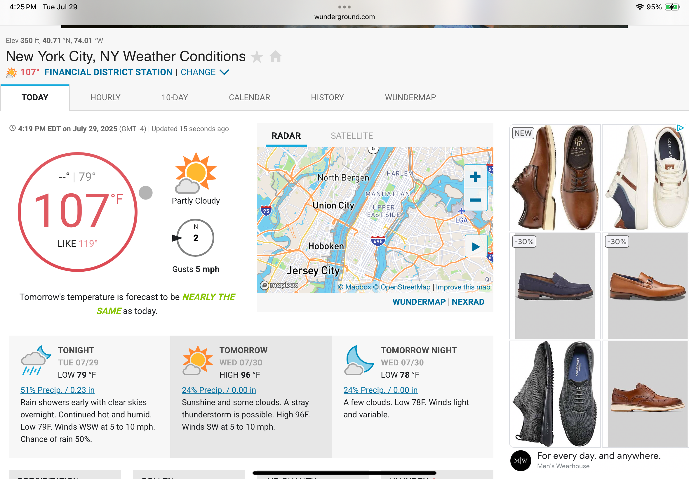
dew points in the mid to upper 60s not that bad The highs around the region so far EWR 100 LGA 100 NYC 97 JFK 96 -

July 2025 Discussion-OBS - seasonable summer variability
TriPol replied to wdrag's topic in New York City Metro
-
You guys some get some numerous showers and thunderstorms with the upslope flow. There is a flash flood watch for Colorado Springs. The GFS predicts up to 2" in Weld County in the next two days.
-

July 2025 Obs/Disco ... possible historic month for heat
Damage In Tolland replied to Typhoon Tip's topic in New England
Everyone everywhere is so happy. Good times -

July 2025 Obs/Disco ... possible historic month for heat
HoarfrostHubb replied to Typhoon Tip's topic in New England
Made it to 94.8F here. 95. Second hottest of the season. -

July 2025 Obs/Disco ... possible historic month for heat
8611Blizz replied to Typhoon Tip's topic in New England
99 might crack 3 digits... about as useful as when BOS gets to -10. -

July 2025 Obs/Disco ... possible historic month for heat
Chrisrotary12 replied to Typhoon Tip's topic in New England
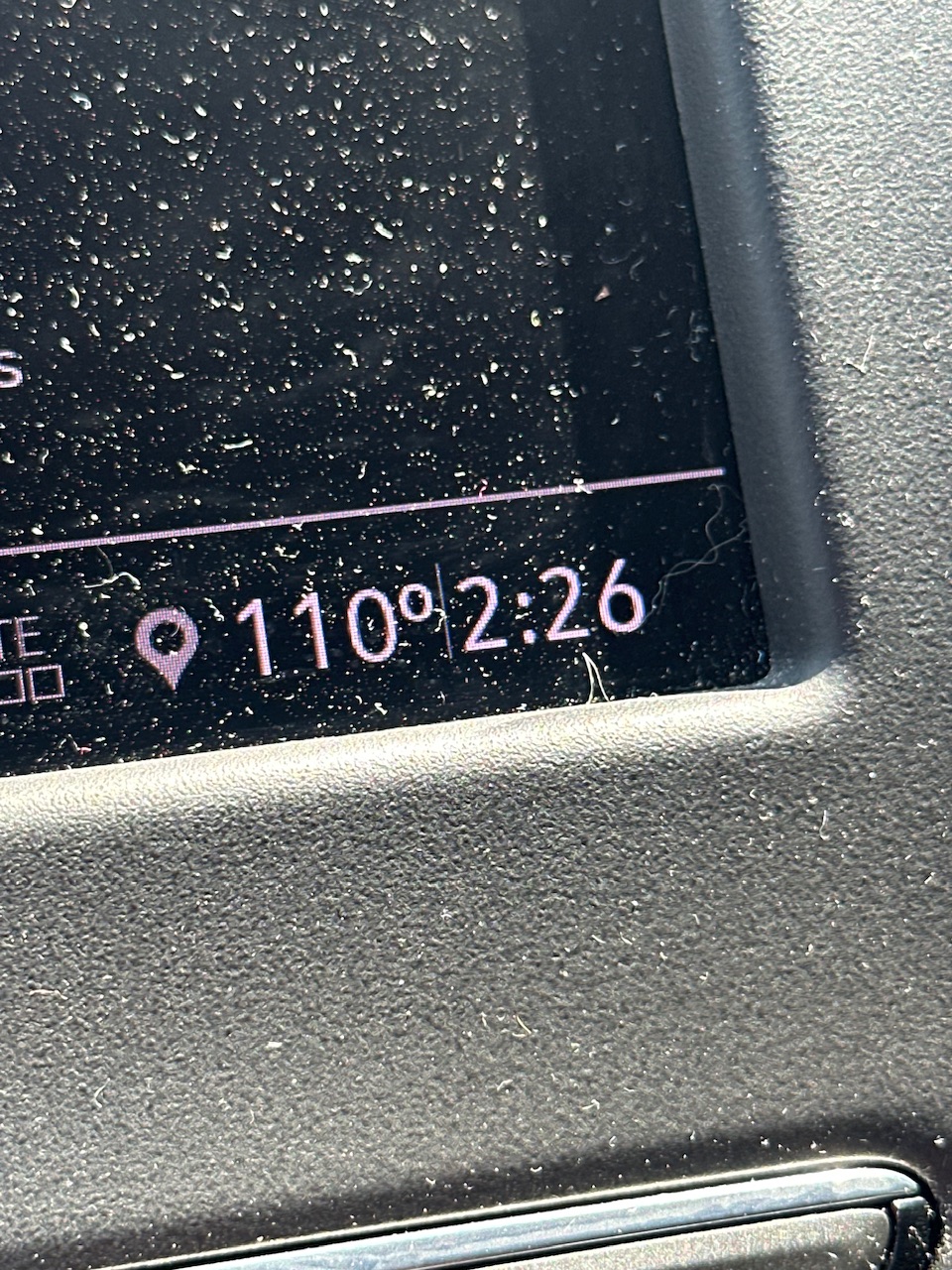
Car thermometer throwing up 100. -
 Looks hot to me! Even Atglen has almost eclipsed 90....just a tad short at 89.9 - West Grove also so close at 89.7 "only" 88.5 so far in EN but we still have some time.....
 -

July 2025 Discussion-OBS - seasonable summer variability
winterwx21 replied to wdrag's topic in New York City Metro
97 with a dewpoint of 67 here. Hot, but it doesn't feel as bad as I thought it would. Dewpoint of 67 isn't terrible. -
July 2025 Obs/Disco ... possible historic month for heat
SouthCoastMA replied to Typhoon Tip's topic in New England
Heading to Crosby Beach in Brewster tomorrow - should be mid 80s there, but we take. -

July 2025 Obs/Disco ... possible historic month for heat
Torch Tiger replied to Typhoon Tip's topic in New England
Hit 113 on the car thermometer on I93 downtown BOS around 2:30 -
the first 8 days of August will be in the 80s or less.
-
July 2025 Discussion-OBS - seasonable summer variability
LibertyBell replied to wdrag's topic in New York City Metro
it's interesting that 1993 isn't on this list, I thought it was hotter than 1991. -
July 2025 Discussion-OBS - seasonable summer variability
LibertyBell replied to wdrag's topic in New York City Metro
nice, that was my dream summer. It's too bad that station wasn't around for 2011 to see if the peak was higher than the 108 it recorded in 2010. -
I see the Euro backed down from that and now keeps it comfortable next week. It certainly would be nice to get a long break from the heat.
-
July 2025 Obs/Disco ... possible historic month for heat
dendrite replied to Typhoon Tip's topic in New England
Mine was spot on when I started it
-

July 2025 Discussion-OBS - seasonable summer variability
Snowlover11 replied to wdrag's topic in New York City Metro
99F feeling like 106! -
Here's something new. My brother's good friend was fishing about 10 miles off of ocean city new jersey and accidentally got a 10ft Great White on the line. They cut the line as the line and rod weren't equipped for it, but got a nice view of it beforehand. Sent from my SM-G970U1 using Tapatalk
-

July 2025 Obs/Disco ... possible historic month for heat
weatherwiz replied to Typhoon Tip's topic in New England
that may actually provide focus for thunderstorms tomorrow...guess it will be a S coast day for some storms -
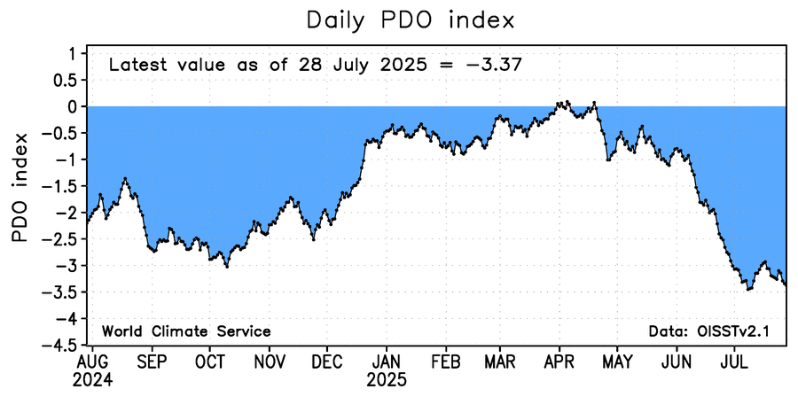
Chance for record low monthly NOAA PDO increasing for July. Current record is -3.8. It’s possible it will even end up just below -4: