All Activity
- Past hour
-
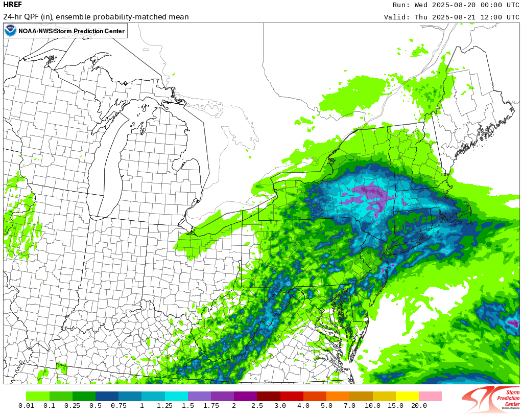
 Not threading but will be interesting this afternoon-tonight. from my view of multi modeling...one axis of potential excessive is near I90 to ne CT-RI, and a secondary axis from Monmouth-Ocean Counties to e LI. Whether out NYC subforum sees isolated 2-5", I'm unsure so no thread. Will post the 24 hour amounts via CoCoRaHs around 845A Thursday.
 -

Hurricane Erin: 100 MPH - 954 mb - NNW @ 13
LongBeachSurfFreak replied to BarryStantonGBP's topic in Tropical Headquarters
As beaches are being rearranged on the outter banks and in the north east. I’m in Montauk by right now and there are already major over washes and beach erosion -
With this PRE expect 4 to 5 inch stripe somewhere in SNE
-
hearing reports of kings being caught already, probably gonna hit the harbors this weekend
-
 The 8/20 0z HREF:
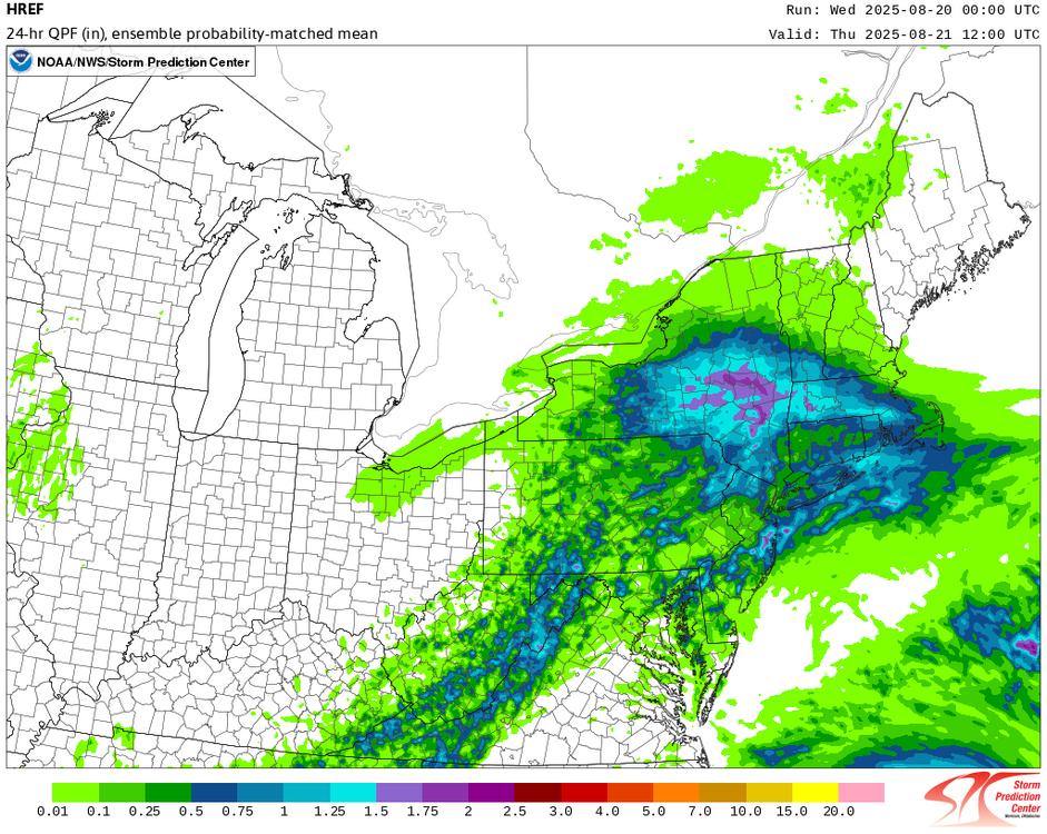
-
Judging by current radar I would agree but this is “allegedly” supposed to drop to the south, we will see. Seeing .50-1.00” around here, will see if that materializes.
-
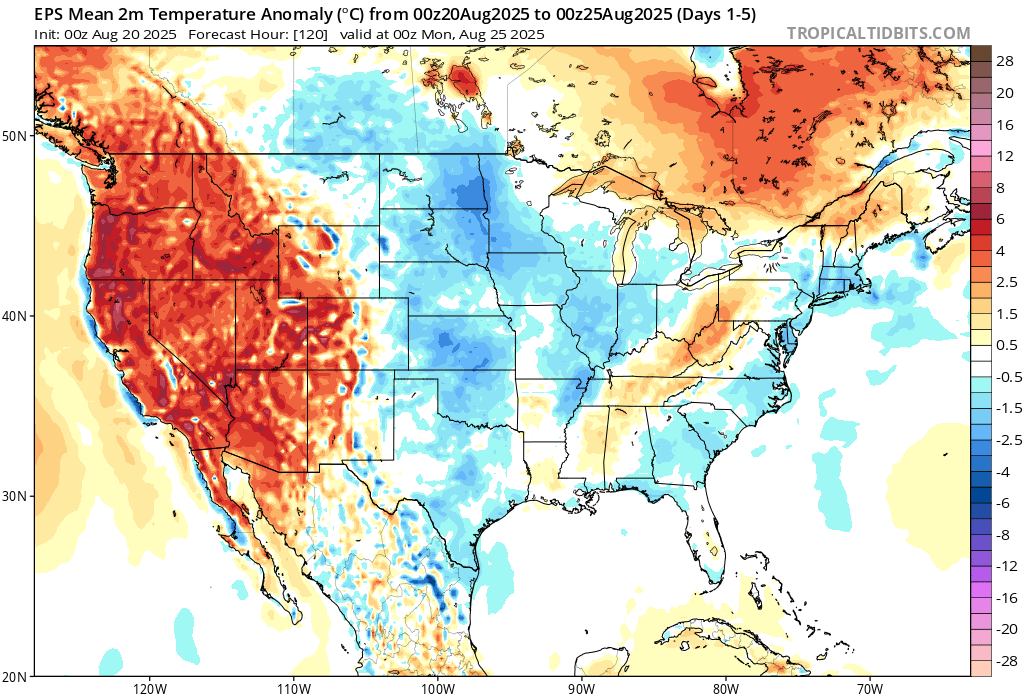
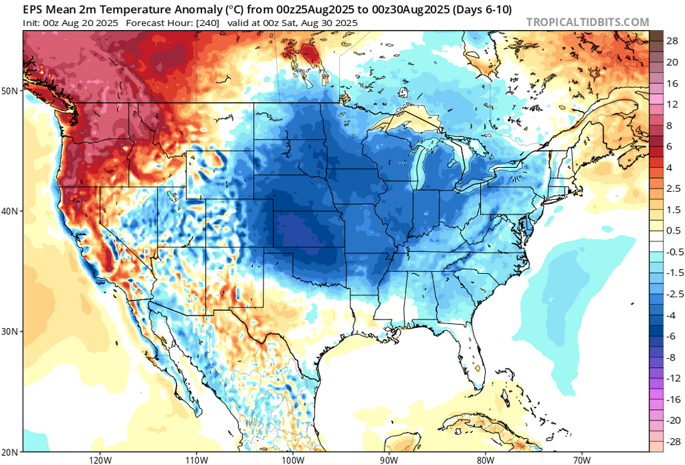
 We generally need a least a recurving hurricane from August 20th through 31st to avoid 90° heat at the warm spots like Newark. This could be the first August since 2011 and 2008 that Newark remains below 90° during this period. We had Irene in late August 2011 and Hanna in 2008. But those systems came further west than Erin will. So this shows that even a storm recurving to our east can cool the pattern when interacting with a trough in Eastern Canada. Time Series Summary for NEWARK LIBERTY INTL AP, NJ August 20th to 31st Max Temp Click column heading to sort ascending, click again to sort descending. 2024-08-31 95 0 2023-08-31 91 0 2022-08-31 93 0 2021-08-31 97 0 2020-08-31 93 0 2019-08-31 92 0 2018-08-31 96 0 2017-08-31 91 0 2016-08-31 95 0 2015-08-31 94 0 2014-08-31 93 0 2013-08-31 91 0 2012-08-31 94 0 2011-08-31 89 0 2010-08-31 98 0 2009-08-31 94 0 2008-08-31 86 0
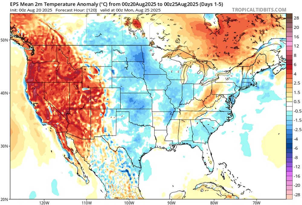
-
Hazardous Weather Outlook National Weather Service State College PA 355 AM EDT Wed Aug 20 2025 PAZ006-011-012-017>019-024>028-033>037-041-042-045-046-049>053- 056>059-063>066-210800- Potter-Cameron-Northern Clinton-Clearfield-Northern Centre- Southern Centre-Cambria-Blair-Huntingdon-Mifflin-Juniata-Somerset- Bedford-Fulton-Franklin-Tioga-Northern Lycoming-Sullivan- Southern Clinton-Southern Lycoming-Union-Snyder-Montour- Northumberland-Columbia-Perry-Dauphin-Schuylkill-Lebanon-Cumberland- Adams-York-Lancaster- 355 AM EDT Wed Aug 20 2025 This Hazardous Weather Outlook is for central Pennsylvania. .DAY ONE...Today and tonight. Scattered, slow-moving and potentially training thunderstorms could produce locally heavy rainfall over one inch in less than an hour. A few instances of flooding in poor drainage areas, and along small streams and adjacent roads is possible later this afternoon and evening. .DAYS TWO THROUGH SEVEN...Thursday through Tuesday. The probability for widespread hazardous weather is low. .SPOTTER INFORMATION STATEMENT... Spotters are encouraged to report significant hazardous weather, including heavy rainfall over one inch and any flooding. $$
-
-
Enjoying my 0.01”
-
I think the nam has the placement about right. More of a Pike border type deal. Maybe a little more down by the wood yard.
-

Central PA Summer 2025
Mount Joy Snowman replied to Voyager's topic in Upstate New York/Pennsylvania
Low of 62 with .02” of rain. - Today
-
0.06” overnight
-
Some signs it warms up again after Labor Day.
-
Hrrr steins and Nam floods lol. Tend to think NAM is a little out to lunch.
-
That will change
-
Bring it! Will be nice to take hour walks in the morning without dripping buckets of sweat.
-

2025 Atlantic Hurricane Season
BarryStantonGBP replied to BarryStantonGBP's topic in Tropical Headquarters
and what about NS forecasts just don't want the funniest name wasted on a crap system
-
Judging by current radar I would say yes. Looks to be steining most of CT.
-

Hurricane Erin: 100 MPH - 954 mb - NNW @ 13
Coach McGuirk replied to BarryStantonGBP's topic in Tropical Headquarters
Hurricane Isabel 2003 165 MPH -
Hurricane Erin: 100 MPH - 954 mb - NNW @ 13
Coach McGuirk replied to BarryStantonGBP's topic in Tropical Headquarters
It was a pin needle cat 5 for a minute. -
Same here. Looks like the 90s are done early for the year. The bad news: Very short-lived garbage pattern ahead for the next few days. Although a bit early for this, but back-to-back days of expected suicide weather starting tomorrow. The good news: Nice pleasant weather takes over just before this weekend begins with temps rebounding back to the lower 80's for Friday into Saturday. Temps really cool down big time early next week. Highs are forecast to be in the low 70s, though there are areas that could be stuck in the 60s or even upper 50s! GFS 00z Monday: GFS 00z Tuesday: Overall, we're reaching what it appears to be the final nail in the coffin on this summer.
-

Summer 2025 Medium/Long Range Discussion
Spartman replied to Chicago Storm's topic in Lakes/Ohio Valley
Summer is over -
2025 Atlantic Hurricane Season
BarryStantonGBP replied to BarryStantonGBP's topic in Tropical Headquarters
So the EPAC hogs the peak season -

2025-2026 ENSO
Stormchaserchuck1 replied to 40/70 Benchmark's topic in Weather Forecasting and Discussion
18-19 and 20-21 through 22-23 -NAO's were really not getting cold at all. The last 2 Winters, there has been cold under -NAO patterns in the east, and the Mid Atlantic has done better in those times.