All Activity
- Past hour
-
We've lost almost 12 hours on it according to the Euro which only goes to make the forecast even further out in time
-
Not too mad at the Euro..looks like it'd def be over 6" if we made it past 144
-
Maps?
-

2025-2026 Fall/Winter Mountain Thread
Buckethead replied to Buckethead's topic in Southeastern States
Not weather related...but worth noting that we are having one helluva solar storm right now. Sent from my SM-S908U using Tapatalk -
Basically a repeat of 12z. Consistency and a big run which stops at 144.
-
Regardless of model, I have often found the "snow depth" field to better represent what you actually experience on the ground, with melting etc - almost like Kuchera+. But some like the GDPS don't use Kuchera for calculating snow depth (just 10:1). I'm not sure which models do/don't, or what site has snow depth derived with Kuchera.
-
Looks like it's been slowing down the past few runs?
-
If the Euro locks in over the next 2-3 runs along w/ the EPS....I think that is a very good thing. I have learned never to speak in absolutes in this hobby. Arrogance would be a pathway to egg on my face!
-
Storm definitely somehow got pushed back a day today. Which annoys me. We were gonna be in NAM range by tonight at one point!
-
Agreed, most of the forum would get 4-8” more after 144 it appears, looks solid to gain some lat after that frame.
-
Op...went boom? Sorry, only got the free pivotalweather
-
18z Euro very similar to 12z. Monster Snowstorm for Many and crippling ice further south
-
Ai has a 2nd event centered again in s va and MD eastern shore.
-
It also seems pretty much aligned to the Euro OP as well. Would think that from days 4-6 they combined would be a pretty good duo.
-

E PA/NJ/DE Winter 2025-26 Obs/Discussion
RedSky replied to LVblizzard's topic in Philadelphia Region
Missed my chance for aurora over snow -
18z Euro
-
It isn't optimism. It is the 18z Euro. Boom.
-

Possible Record Breaking Cold + Snow 1/23 - 1/25
donsutherland1 replied to TriPol's topic in New York City Metro
At this stage, models don't handle tracks and synoptic details very skillfully. Thus, there remains latitude for either a suppressed solution or even a big hit into southern New England. The odds somewhat favor the former, but that doesn't mean that the New York City area can't see a moderate or significant snowfall while parts of the lower Mid-Atlantic have a major snowfall. The 18z GFS came northward. It showed > 6" at Raleigh. Since 1890, there were 44 storms that brought 6" or more snow to Raleigh. While 24 (55%) had no measurable snow in New York City, 12 (27%) had 4" or more and 8 (18%) had 6" or more. The most recent storm to bring 6" or more snow to both Raleigh and New York City was the Boxing Day Blizzard of December 2010. Interestingly, almost 20% of individual EPS members showed 6" or more now, which would be in line with the historic probabilities associated with significant snowfalls in Raleigh. Of course, as noted in the first paragraph, nothing is cast in stone. Historically, if the teleconnection forecast is reasonably accurate, the heaviest snows could favor Washington-Baltimore-Richmond, but it's still possible to get significant snows into New York City. By Thursday, the guidance will be handling the synoptic details with skill. By that time, we should have a much better idea of what to expect. For now, aside from the possibility of a snowstorm, the details cannot be pinned down with much accuracy. At least there's something on the proverbial radar. -
We're right in the wheelhouse for the Euro AI and it's ensembles. If this look maintains for the next 24 hours, then it's probably game on. North of I-70 will somehow score double digits too. They always find a way.
-
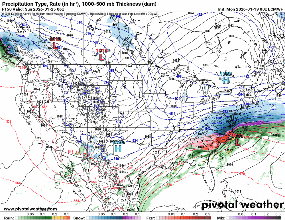
The chart
-

2025-2026 Fall/Winter Mountain Thread
mercurydime replied to Buckethead's topic in Southeastern States
As one who has The Lee Side Blues, this particular setup has my attention. -
Crazy how the second system almost tracks the same on all 18z runs so far
-
Well that does make sense. I shouldn't get attached to one model run, plenty of eye candy coming up between now and the event!
-
For all the suppression we dealt with the 18z GFS actually was a step in right direction Hopefully the tick nw continues tonight
-

Central PA Winter 25/26 Discussion and Obs
WmsptWx replied to MAG5035's topic in Upstate New York/Pennsylvania
He hasn't Tweeted today.