All Activity
- Past hour
-
12.4F here, 13F at DCA. Could hit single digits overnight.
-
-

The “I bring the mojo” Jan 30-Feb 1 potential winter storm
lilj4425 replied to lilj4425's topic in Southeastern States
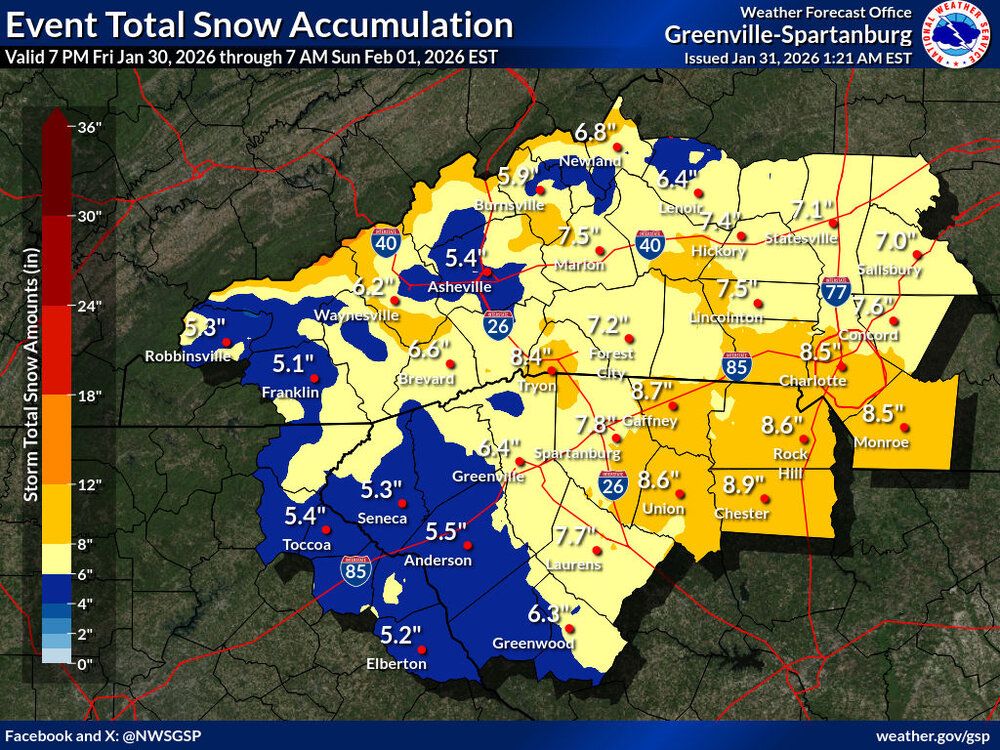
GSP just increased totals substantially:
-

February 2026 Medium/ Long Range Discussion: Buckle Up!
Jebman replied to Weather Will's topic in Mid Atlantic
Or the new Palisades Tahoe. Hey, they got mountains. -
1.3….lets goooo
-

The “I bring the mojo” Jan 30-Feb 1 potential winter storm
wxdawg10 replied to lilj4425's topic in Southeastern States
man, I'm leaning towards you being right. But we've been screwed so many times it's hard not to feel pessimistic when the idea is being floated out there. At this point, i'll take 3 inches and i'm good. -
Sorry if it’s annoying to resurrect this thread but saw this and thought my fellow weather nerds would enjoy:
-
Down to 3. Could make a run at 0
-

Jan 30th-February 1st 2026 Arctic Blast/ULL Snow OBS Thread.
ShawnEastTN replied to John1122's topic in Tennessee Valley
That band appears to disappear as to extends to the south, but I can assume that it goes further south than the radar shows, as the snow has picked up a pretty good tick. Visibility is much lower the snow is very fine but coming down at a good clip, wind whipping it around at times makes it look even more impressive. This feels like this storm is going to really over produce. I reached about an inch total from just the frontal passage snow, and now it's picking up, heaviest it's been since it started. -
Wow.
-
Wow. Down to 1.8 here
-

Richmond Metro/Hampton Roads Area Discussion
eaglesin2011 replied to RIC Airport's topic in Mid Atlantic
Thats all predicted to dry out once it passes the mountains.. Honestly just looking at the radar it looks like this whole storm will be a bust east of the NC Mountains and Charlotte Areas… looking at the radar currently you can clearly see how much moisture is out there but starting to die out when it passes this area because the coastal is talking away it’s energy and developing too far off the coast. In turn drying out everything west & nw of it… Maybe the NC coast gets back in some action late afternoon tomorrow once the storm explodes out to sea and starts to backfill…But looks like Raleigh up to Richmond is dried up… Only chance now would be if everything backfills later from the coastal but again that dosnt look promising at this point especially up this way.. -

Jan 30th-February 1st 2026 Arctic Blast/ULL Snow OBS Thread.
John1122 replied to John1122's topic in Tennessee Valley
Looks like the band is beginning to sink into West Knoxville. Oak Ridge looks to be getting nailed currently. -
Jan 30th-February 1st 2026 Arctic Blast/ULL Snow OBS Thread.
John1122 replied to John1122's topic in Tennessee Valley
1am down to 17. I'll get very gusty winds that blow snow, and then it calms down for a while. It's mostly blown snow off the trees. -

January 30th- Feb 1st ULL and coastal storm obs
Snowncanes replied to JoshM's topic in Southeastern States
If that’s accurate, seems like it’s much closer to the coast than modeled? -

February 2026 Medium/ Long Range Discussion: Buckle Up!
Steve25 replied to Weather Will's topic in Mid Atlantic
It wasn’t far off from a couple systems swinging by, though. For whatever that’s worth. On another note, the regular Euro continues to be pretty unenthusiastic about any potential system next week -

February 2026 Medium/ Long Range Discussion: Buckle Up!
jayyy replied to Weather Will's topic in Mid Atlantic
Tuesday Night A chance of snow after 1am. Mostly cloudy, with a low around 18. Chance of precipitation is 30%. Wednesday A chance of snow. Mostly cloudy, with a high near 30. Chance of precipitation is 40%. Wednesday Night A chance of snow. Mostly cloudy, with a low around 18. Chance of precipitation is 30%. Current point click for next week -

1/30-1/31 Lake Effect Snow Threat - SE WI, NE IL, and NW IN
KeenerWx replied to A-L-E-K's topic in Lakes/Ohio Valley
Looks like primary threat zone shifted east a bit and now looks to center comfortably in Porter County or perhaps even on the line between Porter & LaPorte. Maybe even a bit questionable the extent of plume organization overnight, but of course, even a couple hours of LE can add up. -

Richmond Metro/Hampton Roads Area Discussion
wasnow215 replied to RIC Airport's topic in Mid Atlantic
Radar showing returns in southern Va not on any models -interesting -

Jan 30th-February 1st 2026 Arctic Blast/ULL Snow OBS Thread.
Hurricaneguy replied to John1122's topic in Tennessee Valley
Decent band moving over Greeneville. Rates have increased in the last 15 mins. -

E PA/NJ/DE Winter 2025-26 Obs/Discussion
snowwors2 replied to LVblizzard's topic in Philadelphia Region
Correct per my last post‼️ -
Jan 30th-February 1st 2026 Arctic Blast/ULL Snow OBS Thread.
John1122 replied to John1122's topic in Tennessee Valley
I can't tell which way it's going but the band that sat over me and dumped on me looks like it's made it's way down to Oak Ridge and Clinton. If it's sinking south, it should over take Knoxville soon. -
E PA/NJ/DE Winter 2025-26 Obs/Discussion
snowwors2 replied to LVblizzard's topic in Philadelphia Region
Already down to -3.1° at 1:00 AM‼️ -
E PA/NJ/DE Winter 2025-26 Obs/Discussion
snowwors2 replied to LVblizzard's topic in Philadelphia Region
That’s the good ‘ol GFS for ya‼️ -
I can’t take this all winter. It’s too stressful lol


