All Activity
- Past hour
-
Careful what you wish for.... I got clipped by the pop-up shower around 1:30p. Got a whopping 0.02" out of it!
-

2026-2027 Strong/Super El Nino
michsnowfreak replied to Stormchaserchuck1's topic in Weather Forecasting and Discussion
I was only referring to the comment about 2013-14...I said it in spring 2014 and ill say it to the end...there will never be another 2013-14. Goes far beyond just being the snowiest winter on record. A retired local climatologist did a writeup at the time how it was the most severe winter on record and all the things that made it that. Not repeating that winter has nothing to do with warmer globe or anything like that. It was a winter that defied local climo. As for 2015-16 thru 2024-25, ive discussed it several times as well as how it differed from the warmth of the east. Here it was a product of 5 very mild winters (15-16, 16-17, 19-20, 22-23, 23-24) and the rest around avg (+/- a minimal amt) whereas the east was consistent mild each year. I will say though that 2025-26 was solidly colder than avg. Its colder than the longterm avg and its colder than the coldest 30-year normal in the entire period of record. The departure would be even more impressive if not for a sharp rebound the 2nd half of Feb. Lastly, what has intrigued me more than anything is how the past several decades, milder winters have less correlation to low snowfall (not just les but synoptic too) than they used to. Its more of a crapshoot now. -

2026-2027 Strong/Super El Nino
Stormchaserchuck1 replied to Stormchaserchuck1's topic in Weather Forecasting and Discussion
You might be surprised what a Super El Nino can produce pattern wise in the Winter,, an event that isn't totally east-based allows the GOA low/+EPO to disconnect a bit. A lot of warm bias from limited examples. I think there are some really cold Strong Nino's in the 1895-1948 dataset, or at least very warm Strong Nina's (counter-examples) Here's one.. strong -SOI in the Winter of 1911-12 Another strong -SOI Winter -
Gonna be cutting the lawn twice this week. Been a helluva run for the lawns and gardens.
-
Summer dews and heat are near. LFG!
-
Earlier mesos were chucking mid to upper 60's here. Currently 51, rain, and a north wind.
-
Found this in the NYC forum, the Appalachians are acting like an anti rain force field for pretty much the entire eastern seaboard.
- Today
-
Off and on rain but 3rd bout of heavy rain in past hour in Port Jefferson. Seems like a lit up red line on radar keeps training over my area. Gonna be some big totals from this..
-
Looked at the radar and saw nothing close by, looked out the window 10 minutes later and it was pouring, in downtown Bethesda. Guess that cell popped up right over me.
-
Look what's developing to your SW heading your way
-

2026-2027 Strong/Super El Nino
LakePaste25 replied to Stormchaserchuck1's topic in Weather Forecasting and Discussion
FWIW, whether it’s more like 1997-98 or 2015-16 doesn’t really change the odds of a big NE snowstorm or two between breaks of the pacific jet IMO. Just really getting into semantics here of what more closely defines a super Nino pattern in the western hemisphere. -
Live and free. Donations accepted to offset costs. https://ginxweather.com
-
2026-2027 Strong/Super El Nino
LakePaste25 replied to Stormchaserchuck1's topic in Weather Forecasting and Discussion
Yup, but this exact issue that Ben points out is what many of us believe contributed to the super torch of December 2015, where you had the Nino-like pac jet extension, but then systems cut in a Nina - like SE ridge. Will be interesting to see if Aigle is right, and thus the forcing is so overwhelmingly strong that we see a more broad pacific jet-southern stream connection similar to 1997 instead of 2015. -
Got my son’s baseball game in just in time. Showers now and 0.16” so far.
-
Missed by a couple miles with the first round
-
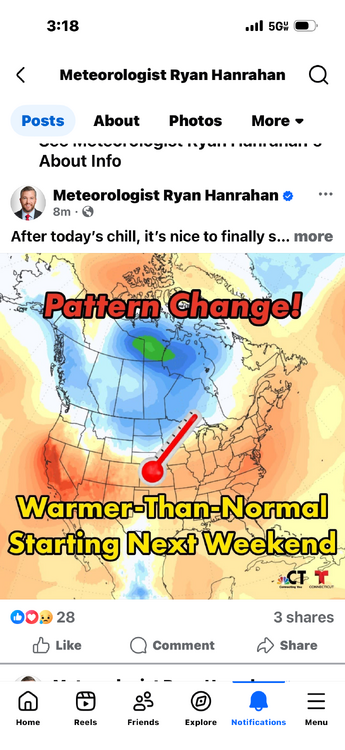
Did the pattern ever change?
.thumb.png.a5189c9b0130fb5b4552994f01e4d191.png)
-
Got a few drips. Hope more pops up to the SW.
-
Sprinkles popping up IMBY. Small red cell in Takoma Park/Langley Park MD.
-
Last I knew, Smith was released during the day and pumped back up at night to get power when needed ,(read expensive)...a 2 lake system. So, I'm guessing power demand affects it too. Looked at this site, and it is down 5'... https://www.smithmtn.com/lake-levels/ ...but it's been lower. Appalachian Power used to have a great visitor center at the dam with large models that explain their system. It's out of the way, but really worth it. Staffed by volunteers too. Been years since I was down that way...hope it's still in operation.
-
Spurts if heavy rain down here in Monmouth County. Rain looks to probably miss most of this area. Sussex county getting a much needed soaking g.
-

E PA/NJ/DE Spring 2026 Obs/Discussion
RedSky replied to PhiEaglesfan712's topic in Philadelphia Region
56F light rain and dank -
Until there's an event that originates from the SE on this side of the mountains it's gonna be disappointment for us. I've given up even one iota of hope from any frontal passage coming in from the NW.
-

2026-2027 Strong/Super El Nino
snowman19 replied to Stormchaserchuck1's topic in Weather Forecasting and Discussion
The CFS just continues to go higher with the peak: And building upon what LakePaste just posted, extreme (super) El Niño events offer better forecast reliability with their very strong ocean-atmosphere coupling: -
-
Just had a Facebook video reminder for May 9th,2020 and the snow flakes we got in little ferry. Was also amazed at how far behind all the tree growth was compared to this spring. Ohhh and it's raining in Bradley Beach. Cold as hell too.


.png.7d42e6f24ddd636ee831244604dfe29f.png)


