All Activity
- Past hour
-
I said this in the MA forum but figured I’d send it here too… I believe there is potential for 12"+ for coastal regions from Delaware to Mass, but I am honestly decently concerned about a potential rug pull I-95 N and W with this one. A storm as intense as this is likely to have a more consolidated precipitation shield which slams the coast, but can make it difficult for those bands to pivot farther inland. There is legitimate risk the phase does not occur until north of our latitude unless we see more digging upstream. The inverted trough is a wild card that could make up for it in spots though. Not to mention, surface temperatures are marginal with this one, and we could see a period of white rain cut down on totals. Hoping for the best, but I see clear warning signs and parallels to storms like January 2015, January 2018, January 2022, Boxing Day, etc.
-
Here it comes.
-
Light snow to the region at 45
-
I like a Miller nAm please
-
-
It's been coming down pretty good for the last hour or so, after the column finally saturated. Temp is 30F
-
Poor Randy is on a flight. If only he were here. You have me, though! But that might be a net minus
-
It would help greatly if we could put some accumulation down between 7 -10am Sunday.
-
We have a storm watch people up to 55KTS
-
We can have a general idea prior to the storm, but exactly where will be a nowcast and forecast adjustments would happen accordingly.
-
Never saw a drop of rain or mix here. Just started as snow at 3:10 PM. 34F
-

“Cory’s in NYC! Let’s HECS!” Feb. 22-24 Disco
ma blizzard replied to TheSnowman's topic in New England
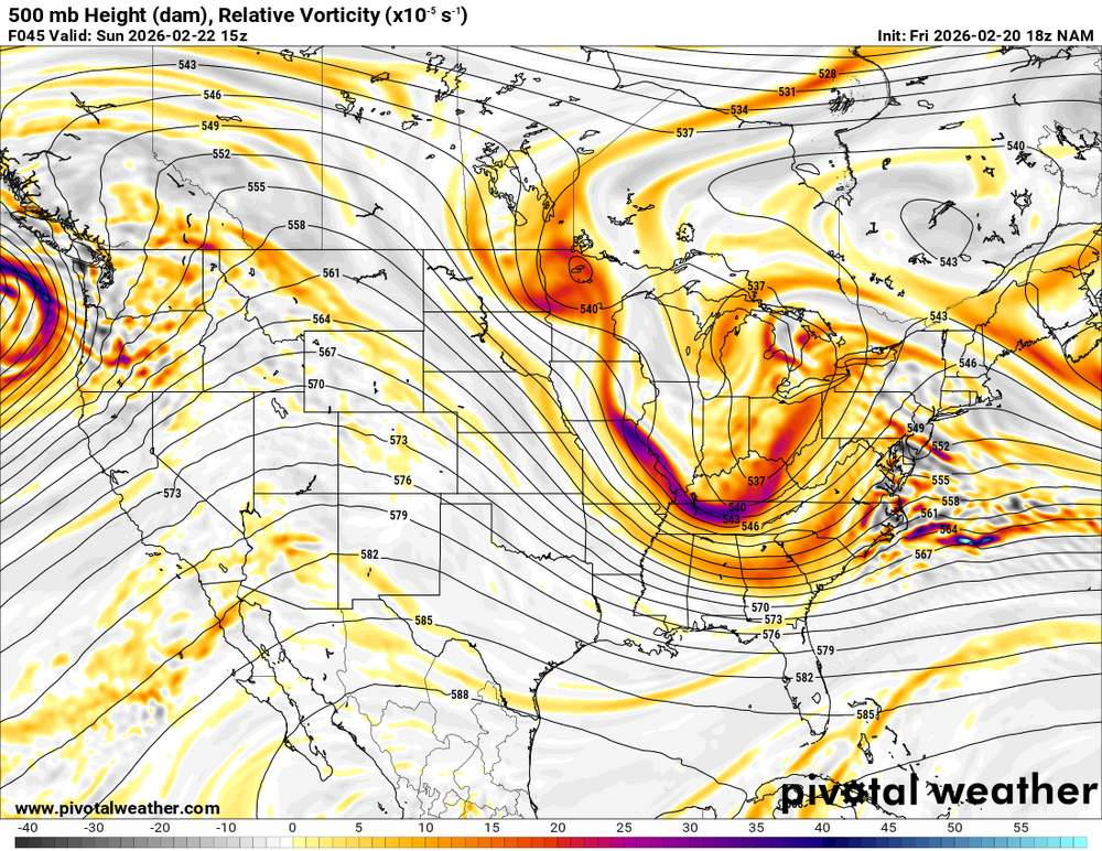
at 42 heights noticeably higher ahead of the S/W at 500 compared to 12z -
We were looking at different hours... that 3 hours made a difference
-
yes it's me feen, a.k.a tonylovesnow. Sorry if i ever offended anyone im a new man and ive changed into a whole new still annoying but a bit more mature. @TriPolyes that was my picture i floated around on twitter. Cause i do believe if we tuck a little more it could realistically mimic Boxing day blizzard at least to a point!
-
Your forecast gets me into the warning criteria
-
-
thanks for the confirmation
-
if you weren't around to see it, you wouldn't understand. look through the google machine for pics of rt 128 and all the stranded vehicles
-
Yeah it is a hair more negative at 42. And the ridging is so clearly better. Don't even have to look at the surface to see it's getting development going much further west... but I did peek at the surface earlier and there were showers/snow in TN/KY.
-
Can I get double NAM'd? That a thing?
-
That appears to be much closer to the coast than before.
-
It’s more negative tilt than previous
-
guys dont post if you dont know what you are talking about
-
I was looking at H5@39... so you are ahead of me... maybe something switches in 3 hours... and it does
-
pretty much all of our snow has been obliterated lol


