All Activity
- Past hour
-

Feb 10-11 Mid Week Minor Event - Ride the hot hand?
Damage In Tolland replied to HoarfrostHubb's topic in New England
I’ll be fine with 1-3 refresh and then track the bigger one next weekend -
 Won't even approach records though as they are in a whole nother league... double digits in the negatives for records..
 -
 Id lean against it also, But I never right it was likely so maybe I’ve gone from giving it a 40% to a 20% chance. But the adjustment we need is still minor, a stronger pacific wave ejecting. How many times did we have a snow threat at 150 Hours and that trend hurt us by causing a more amped wave to trend north? It happens all the damn time, when we don’t want it to! Why can’t I happen when We need it? Because we are living in a simulation programmed by someone who was hurt in a past life my a mid Atlantic snow weenie and the whole purpose of this simulation is to inflict the maximum amount of emotional trauma on DC snow lovers.
 -

Winter Storm Threat *Technical* Discussion. No Op Run PBP or Snow maps
CAPE replied to CAPE's topic in Mid Atlantic
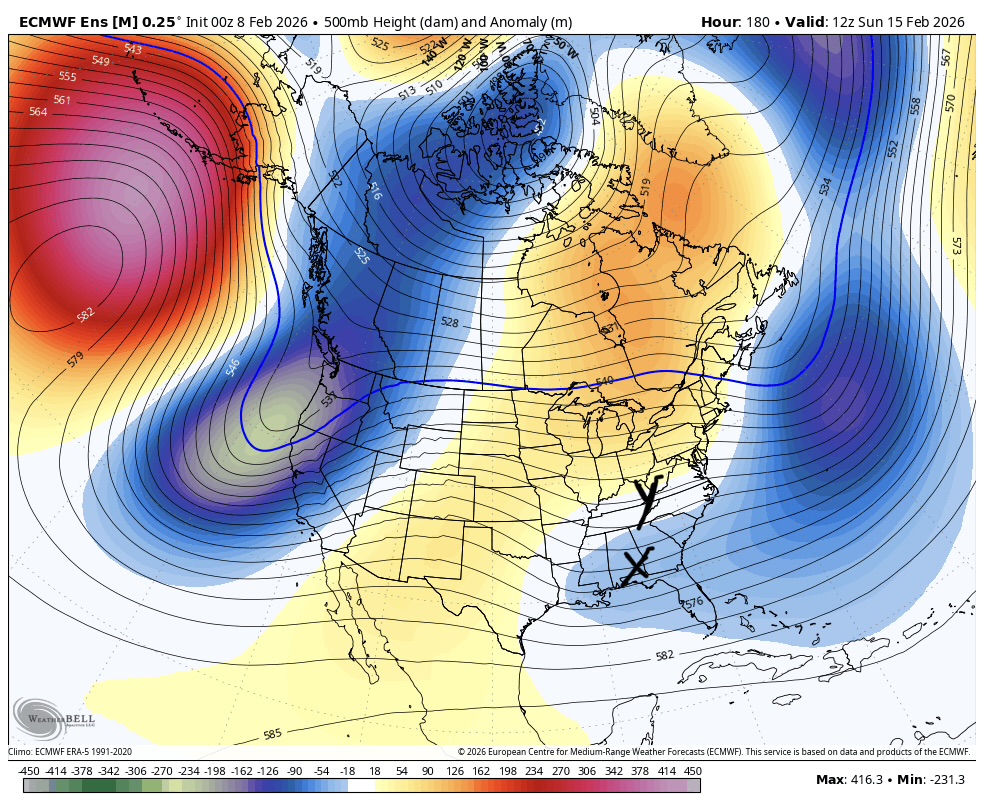
Recent cycles have ejected significant energy and the outcome in those cases has been a low cutting west/ Miller B. 6z GFS does the latter, but the coastal gets going at our latitude. Still a range of possibilities imo. Timing with energy moving into/through the 50-50 region is also going to be a key factor in the outcome. Everything is on the move. -
Is we back? February discussion thread
Damage In Tolland replied to mahk_webstah's topic in New England
Snowy Tuesday night and next Sunday. Machines -
 -3 low but wind is pretty meh here.
 -
 Is the cold thick?
 -
 In that regard, 6z Eps did improve over 0z with the stronger wave and the trough off the east coast moving out quicker. Enough? Who knows at this point.
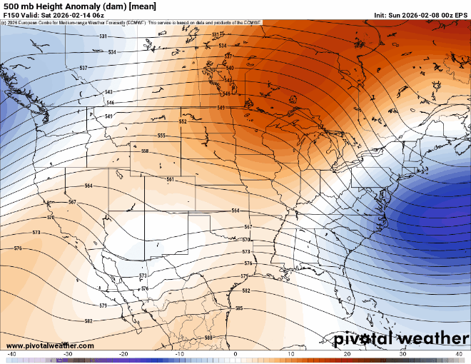
-

Central PA Winter 25/26 Discussion and Obs
Mount Joy Snowman replied to MAG5035's topic in Upstate New York/Pennsylvania
Current temp of 5 is the low. This has to go down as one of the colder Super Bowl Sundays in history. Just frigid. Although I agree with what @Itstrainingtime said yesterday, that I didn’t really notice the winds being bad here all day. The house never made the sounds it typically does in high winds, perhaps the slight change in direction was enough to mitigate but it just didn’t seem that serious here. -
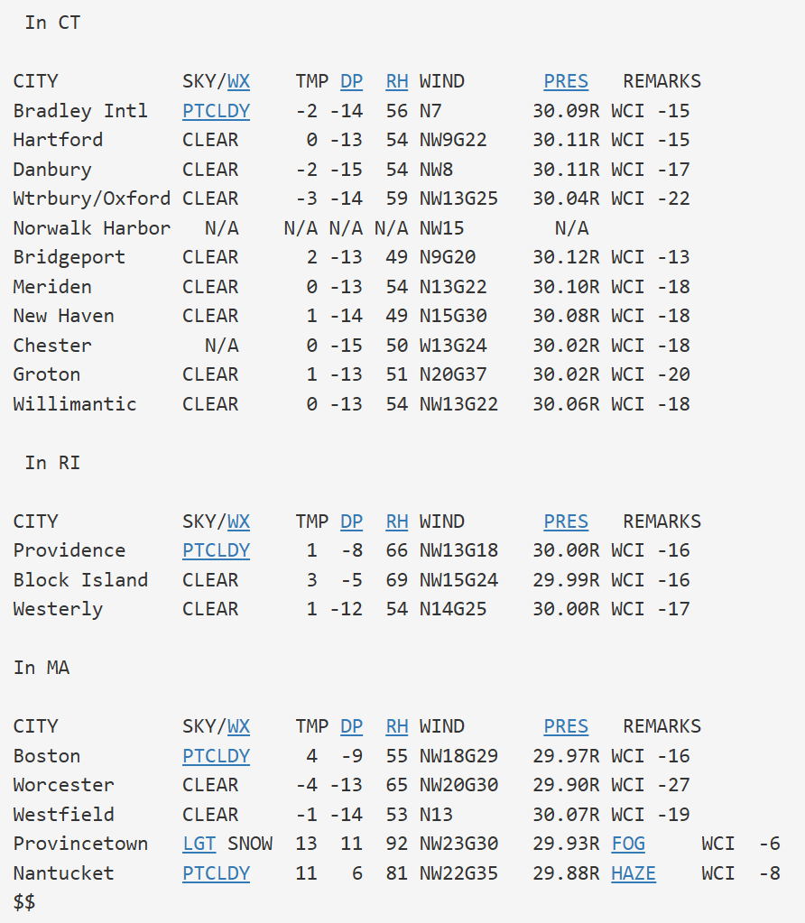
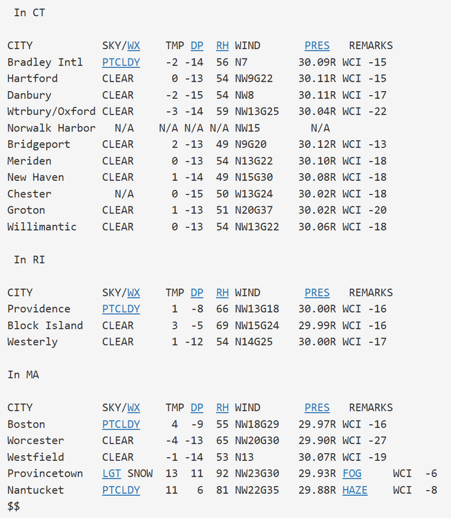
Brutal cold right down to the shoreline. Not often you see BDR HVN and GON approach 0. Wind chills 13 to 22 below @ 7AM
-
Winter Storm Threat *Technical* Discussion. No Op Run PBP or Snow maps
psuhoffman replied to CAPE's topic in Mid Atlantic
We are still far enough out for that to adjust again. We need that Baja wave to eject stronger and the Atlantic flow to be slightly less suppressive. It wouldn’t take much, an adjustment well within a typical 150 hour error, but we’ve been so unlucky for so long that I think we juts assume nothing good will happen. Which given our climo is usually right. Snow here isn’t a “fair” game. There are like 10 major variables and we need almost all of them to go right. There are way more losing combinations than winning ones so every threat is more likely to fail. I mean even in the rare cases when we get the flow to be cold enough then we have to worry the storm gets squashed or goes south of us! But eventually if we keep playing we will roll the right combination and get lucky. -
 Will wait until 84 hours out to be certain, but I’m starting to think that we’ve lost this one. Maybe it’ll morph into a minor event?
 -
Yep.
-
Feb 2023 The one real cold shot we had that entire winter. The difference that time it was all brown. Completely snowless. January didn't even make it below the 20s the entire month. Horrific winter.
-
That was a much colder 15 day period than we just had. Minimum 15-Day Mean Avg Temperature for Islip Area, NY (ThreadEx) Click column heading to sort ascending, click again to sort descending. 1 12.0 1979-02-06 through 1979-02-20 0 2 12.2 1979-02-05 through 1979-02-19 0 3 12.9 1979-02-07 through 1979-02-21 0 4 12.9 1979-02-04 through 1979-02-18 0 5 14.4 1979-02-03 through 1979-02-17 0 6 14.4 1979-02-08 through 1979-02-22 0 7 15.1 1967-12-30 through 1968-01-13 0 8 15.2 1979-02-09 through 1979-02-23 0 9 15.7 1979-02-02 through 1979-02-16 0 10 15.8 1967-12-29 through 1968-01-12 0 11 16.0 1967-12-31 through 1968-01-14 0 12 16.4 1979-02-01 through 1979-02-15 0 13 16.4 1968-01-02 through 1968-01-16 0 - 16.4 1968-01-01 through 1968-01-15 0 14 17.0 1968-01-03 through 1968-01-17 0 15 17.1 1968-01-04 through 1968-01-18 0 16 17.1 1967-12-28 through 1968-01-11 0 17 17.2 1979-02-10 through 1979-02-24 0 18 17.6 1979-01-31 through 1979-02-14 0 19 17.7 1980-12-31 through 1981-01-14 0 20 17.8 1968-01-05 through 1968-01-19 0 21 17.9 1981-01-03 through 1981-01-17 0 22 18.0 1981-01-01 through 1981-01-15 0 23 18.0 1977-01-11 through 1977-01-25 0 24 18.1 1967-12-27 through 1968-01-10 0 25 18.1 1981-01-02 through 1981-01-16 0 26 18.2 2005-01-17 through 2005-01-31 0 27 18.2 2005-01-18 through 2005-02-01 0 - 18.2 1977-01-17 through 1977-01-31 0 28 18.3 1981-01-04 through 1981-01-18 0 29 18.3 1977-01-10 through 1977-01-24 0 30 18.4 2017-12-26 through 2018-01-09 0 - 18.4 1977-01-12 through 1977-01-26 0 31 18.4 1977-01-16 through 1977-01-30 0 - 18.4 1977-01-09 through 1977-01-23 0 32 18.5 2026-01-24 through 2026-02-07 0
-
Winter Storm Threat *Technical* Discussion. No Op Run PBP or Snow maps
psuhoffman replied to CAPE's topic in Mid Atlantic
All the guidance has flipped places. The GEPS is now the most favorable and the Euro stuff the least. -
Winter Storm Threat *Technical* Discussion. No Op Run PBP or Snow maps
Terpeast replied to CAPE's topic in Mid Atlantic
Disappointed, but not surprised. The red flag yesterday and even the day before was that guidance was trending weaker with the undercutting energy beneath the hudson bay ridge. -

Friday February 6 FROPA / WINDEX small event
SouthCoastMA replied to HoarfrostHubb's topic in New England
I believe the 3-4" in Pocasset. That area was on the eastern flank yesterday afternoon. Also Wareham with 5-6" was a kick in the nuts..which is about 5-7 miles west of here -
Looks like -5.8 will do it Man stuff not fake
-
yes if it was only a couple of days away and it wasn't the GFS - look at the 06Z GFS and report back...
-

E PA/NJ/DE Winter 2025-26 Obs/Discussion
Duca892 replied to LVblizzard's topic in Philadelphia Region
Feels like next week on GFS is just a much warmer version of the last storm we had -

Central PA Winter 25/26 Discussion and Obs
pawatch replied to MAG5035's topic in Upstate New York/Pennsylvania
That’s a good point you make.That explains why such a high temperature. Because once that front come through it was all downhill. -
We melt
-
Oz guidance across the board didn’t eject enough energy and trended more suppressive with the Atlantic look. Bad combo. Result is this. We need x to be where y is and stronger but that’s redundant because for it to be where y is it would have to be stronger.

-
Doesn’t look like much going forward.