All Activity
- Past hour
-
 Wide left and right but a couple of cloud to ground strikes and the acoustics were nice.
 -
Tolland finally getting rain
-
A few flashes. It solid 3-4”/hr
-
Unloading
-
S NH wins again
-

NEW DISTURBANCE: Central Tropical Atlantic (0/40)
WxWatcher007 replied to BarryStantonGBP's topic in Tropical Headquarters
The operational runs are nonsense but the GEFS and EPS definitely have a strong TC genesis signal. -

E PA/NJ/DE Summer 2025 Obs/Discussion
LVLion77 replied to Hurricane Agnes's topic in Philadelphia Region
Wow, did not expect nearly an inch of rain this evening. A welcome surprise and good fortune in the center of that band of heavy showers heading into very dry weather pattern. -

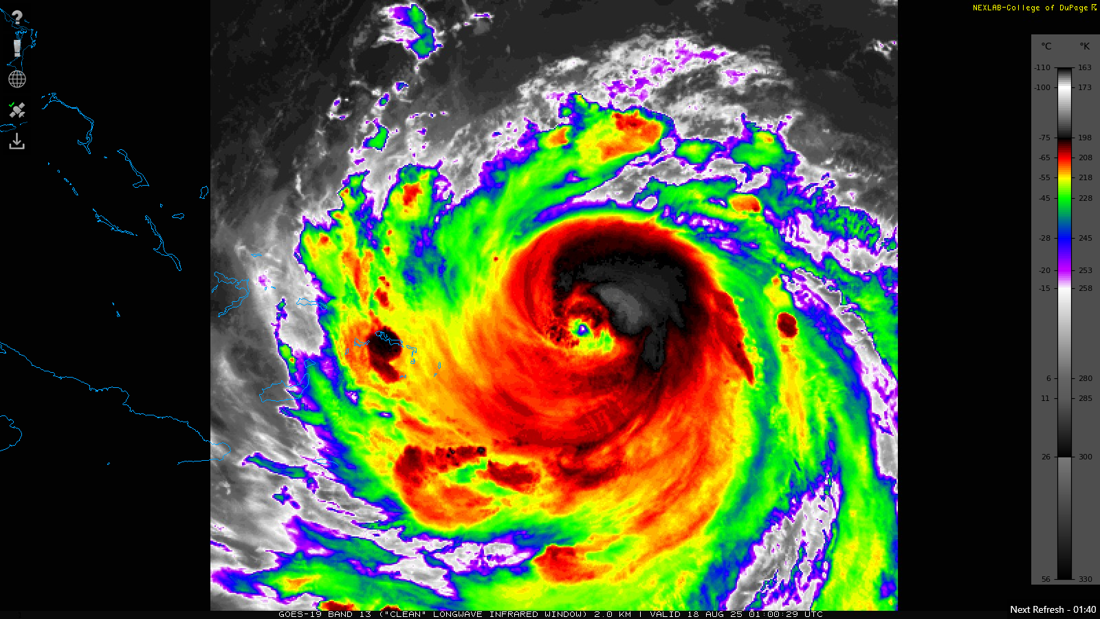
Hurricane Erin: 125 MPH - 946mb - WNW @ 13
nvck replied to BarryStantonGBP's topic in Tropical Headquarters
Eye really clearing out over the last hour or so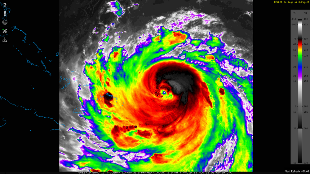
-
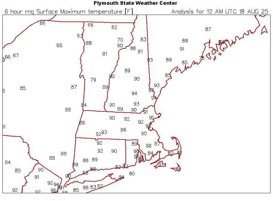
Highs: EWR: 96 TEB: 94 New Brnswck: 94 PHL: 93 BLM: 93 TTN: 93 LGA: 91 NYC: 91 ACY: 89 ISP: 86 JFK: 85
-
 Nice downpour here that dropped a good 1/2 inch-settles the dust for awhile
 -

E PA/NJ/DE Summer 2025 Obs/Discussion
RedSky replied to Hurricane Agnes's topic in Philadelphia Region
Drought cancel uncancel cancel Ripping hard again feels like another 2" and 6" on the month -
it's the same thing every year-kind of like radar hallucinations in the winter on an OTS storm...
-
In terms of Erin and how it intensified, the developing storm, processes, etc. absolutely should be discussed and talked about. What Erin did was special and it’s extremely important these processes continue being studied. But this never had a chance of making landfall. When it comes to landfalling tropical systems, particularly in the Northeast, there is a very clear and distinct weather pattern that needs to be in place. We had the exact opposite of that weather pattern. When you don’t have a prime pattern in place, these storms will re-curve. All these people out there on social media or whatever playing the “but if” game…weather doesn’t work on ifs. There are basic principles and concepts. “If the trough does this…if the high does this…if this if that, the models can change”…that’s not how this science works. Granted, it isn’t an exact science but there are still basic principles and concepts which provide the guidelines and basis. If there were going to be changes to any features or structures the pattern…those signals would exist within modeling or teleconnections and those signals were never, ever present. One run of an OP doesn’t constitute these as being present either. If anything, there was a better shot at the storm remaining on a west heading towards Florida, that would have been probable if Erin was within an environment not favorable for strengthening or organization, otherwise Erin was always going to gain latitude. there was always going to be some range as to exactly how far west Erin would get either prior to re-curving or while re-curving and it was never going to be enough to be a “close call” and that’s because there was never a pattern or feature which would have shunted it even further west. A bunch of people playing the “if game” doesn’t change what the reality was, it doesn’t change what the meteorology and physics dictated would happen.
-
 Highs: EWR: 96 TEB: 94 New Brnswck: 94 PHL: 93 BLM: 93 TTN: 93 LGA: 91 NYC: 91 ACY: 89 ISP: 86 JFK: 85
 -

Hurricane Erin: 125 MPH - 946mb - WNW @ 13
wthrmn654 replied to BarryStantonGBP's topic in Tropical Headquarters
big eye now -
good luck !
-
Violence forming now
-
Maybe another tropical threat after Erin...
-
Interesting theory. (But it's beyond my knowledge of silvaculture....hopefully someone knows)
-
Good song for the coming week. Never heard of this guy before today. It's a good song if you enjoy folkish stuff. I guess he's local going to be at the beachcomber next week. 75 and sunny!
- Today
-
Got 0.4 with that nice shower which is a deluge for these arid parts. Not much lighting and just a little wind. Looking forward to lower temps for a few days
-
I started keeping a weather journal in Sept 2002. I was surprised looking back at it, how many days there was snow in October. It seems those massive Winters hit early, consistently, and end late. My last snowfall in 03 was in early May, and it snowed over 100" that Winter. The odds of a major one is probably 5:1 less this Winter, while closer to average doesn't have as bad odds.. so yeah, October might come in a little warm (The PDO's top correlation month of the year is Oct).
-
CAM's had a broken line pushing offshore S coastal zones tonight, we'll see if they bang 9-11pm
-
 Finally got the car wash today and then a half inch of rain 6 hours later. Oh well
 -
 Central Park picked up 0.64" rain in an hour. While impressive, that was just half of the hourly record of 1.28" for August 17 that was set in 1974.