All Activity
- Past hour
-
Reached a high of 34 here today, after a morning low of 17.
-
I like that radar look…better hold together
-
some of us are about average or a little over.
-

Pittsburgh/Western PA WINTER ‘25/‘26
colonel717 replied to Burghblizz's topic in Upstate New York/Pennsylvania
Snow showers starting to build back in. Looks like some decent squalls north of Lake Erie heading south. Lets see what we can add to what we already got. -

Friday February 6 FROPA / WINDEX small event
CoastalWx replied to HoarfrostHubb's topic in New England
Yep. -

2025-2026 Fall/Winter Mountain Thread
Buckethead replied to Buckethead's topic in Southeastern States
Yeah I have sustained winds of 10-15 with frequent gusts over 30. Sent from my Pixel 10 Pro using Tapatalk -
Deer sh!t covered. Mission accomplished
-
A legitimate burst of steady snow here in Reisterstown.
-
28 light snow Cloverly MD
-

Richmond Metro/Hampton Roads Area Discussion
eaglesin2011 replied to RIC Airport's topic in Mid Atlantic
Prob almost an inch here in Glen Allen 295 .. looks like should be wrapping up within the next hour then we bring on the freeze and wind -

Friday February 6 FROPA / WINDEX small event
8611Blizz replied to HoarfrostHubb's topic in New England
Some TV mets are mentiong how a small shift in the trough will mean a big difference. -
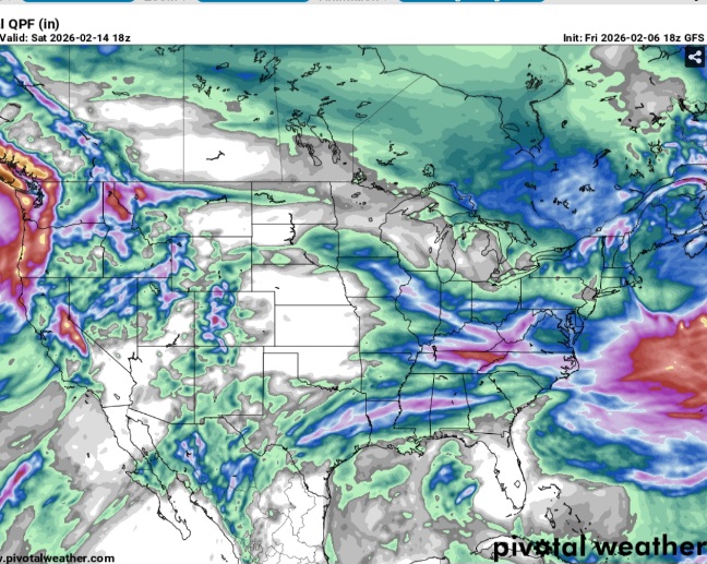
 GFS 18z 500mb, 700mb, 850 mb are cold the 2m temps are marginal. QPF is light.
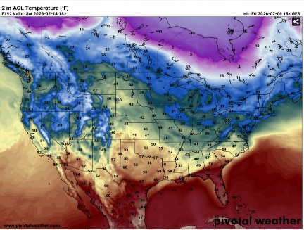
-
Just got home. Temp is 41 but the wind is cranking.
-
Yeah so they put out the special weather statement but don't even issue an advisory? I mean they have northern Haywood under like 4 to 6 inches but just issue a special weather statement... Makes no damn sense to me. And I think the northern counties should be under a warning...
-
 Grocery shopping. @bncho saved me
 -
Friday February 6 FROPA / WINDEX small event
8611Blizz replied to HoarfrostHubb's topic in New England
Cory on fellger and maz -

February 2026 Medium/ Long Range Discussion: 150K Salary Needed to Post
CAPE replied to Weather Will's topic in Mid Atlantic
Spacing!! -
Swain-Haywood-Graham- Including the cities of Alarka, Almond, Bryson City, Luada, Wesser, Waynesville, Waterville, Canton, Cruso, Cove Creek, Robbinsville, and Stecoah 301 PM EST Fri Feb 6 2026 ...SNOW EXPECTED OVER THE HIGH ELEVATIONS OF THE SMOKIES TONIGHT AND EARLY SATURDAY... Snow showers will develop across the high elevations of the Smokies this evening and then will continue through the early morning hours on Saturday, and finally tapering off by mid- morning. Elevations above 3500 feet right near the Tennessee border could get as much as 4-8 inches of snow by the time it ends, which would result in dangerous travel conditions on US Highway 441 across Newfound Gap. More populated areas of Graham, Swain, and Haywood counties may only get a dusting of snow, with maybe up to an inch around Balsam Gap and Soco Gap.
-

Central PA Winter 25/26 Discussion and Obs
SnowPlowGuy88 replied to MAG5035's topic in Upstate New York/Pennsylvania
Starting to lay on hard surfaces. Just a dusting, but steady light snow for the last 20 minutes or so. -
Friday February 6 FROPA / WINDEX small event
CoastalWx replied to HoarfrostHubb's topic in New England
Still disagreement on the troughs -
Damn. Jealous as hell but congrats all
-
Real light snow now
-
Awesome. i hope i can eke out an inch here.
-
February 2026 Medium/ Long Range Discussion: 150K Salary Needed to Post
CAPE replied to Weather Will's topic in Mid Atlantic
Just what we needed. NS vortex somewhat weaker and more in the 50-50 low position instead of southward killing our shortwave -
 Very much so, agreed! Would take that in a minute!