All Activity
- Past hour
-
 That would have been one hell of a day in the modern age
 -
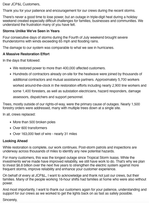
This is old news by now but there was quite a bit of damage with those holiday weekend storms. No wonder it took so long to get the power back. Next hurricane of substance that blows through the tri-state is going to be a big problem. Some people around my part of NJ were without power for a week. Something that affects the entire area with 60-80 mph winds is going to be a nightmare in terms of power outages. Not a matter of if but when.
-
https://hudsonvalleypost.com/new-york-could-see-strongest-winter-in-a-decade/?tsq=sl&fbclid=IwdGRjcATCHlFjbGNrBMIePmV4dG4DYWVtAjExAHNydGMGYXBwX2lkDDM1MDY4NTUzMTcyOAABHjp6J1TGE9ocHNhW8ZxgHKT91qC7PujWKSAcNuIu8S94zzo0OpS9RyHnJfyZ_aem_HlxhPu2lZX-qOcRhk70wDw
-

2026-2027 Super El Nino
MJO812 replied to Stormchaserchuck1's topic in Weather Forecasting and Discussion
https://hudsonvalleypost.com/new-york-could-see-strongest-winter-in-a-decade/?tsq=sl&fbclid=IwdGRjcATCHlFjbGNrBMIePmV4dG4DYWVtAjExAHNydGMGYXBwX2lkDDM1MDY4NTUzMTcyOAABHjp6J1TGE9ocHNhW8ZxgHKT91qC7PujWKSAcNuIu8S94zzo0OpS9RyHnJfyZ_aem_HlxhPu2lZX-qOcRhk70wDw -
 Imagine 96% of the world rendered dark interminably due to a Carrington redux event
 -

Mid-Long Range Discussion 2026
WinstonSalemArlington replied to BooneWX's topic in Southeastern States
-
 Summaries I made using data from The Tornado Project.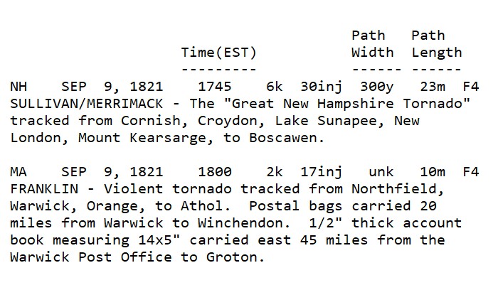
-
Yes, every location/region "pays the piper" eventually. Just it varies for each wx phenomena and climo! I don't think the general public understands this, and since some events are so uncommon and exceed regular memory or lifetimes, ppl freak easily. I get it, experience matters, but that's where knowing and understanding wx history comes in. I can not emphasize that enough! The point I was trying to drive home overall is that a min Cat 1 landfall, which is *not* extreme or unusual in the large pix for New England, will be treated as such b/c *impact* will be enormous. What I see all too often these days is that ppl conflate a wx event intensity w/ impact. They are not always directly correlated. Biggest SNE case I quote a lot is Dec 13, 2007 4-8" traffic nightmare. Run-of-the-mill storm well forecast, just timing was bad, and decisions made by officials/authorities made it epic bad from dismissing everyone from work/school noon-1pm when the S+ was underway. That scale of impact had almost nothing due to w/ the 4-8" of snow itself here. We handle 4-8" easily the vast majority of the time. So the hurricane massive and record power outages will largely be a function or increases population, infrastructure, mismanaged of land (tree trimming, etc), and things like power companies not prepared for the scale of impact (not enough staffing/equipment increase over time to handle the much larger population and infrastructure). And this will happen w/ a min Cat 1 hurricane almost certainly. Sure, you can blame the fact that we have gone record long w/o a landfalling hurricanes here, but the door swings both ways. Would it be better to have more landfalling hurricanes so we avoid the inexperience and complacency???
-
Still watching Gulf early next week:
-
 Might add '38's drag race from the Outer Banks to LI, and a mid-September timing when the water temp is at/near peak.
 -
 There are people here who found last winter to be challenging...they sure ain't going to be able to handle the aftermath from a direct hit by a major hurricane..
 -
i wouldn't consider it a miss north with 90°+ expected every day this week.
-
In the Atlantic "quiet" phase 1970-1994, we got 3 landfalling hurricanes here. Since 1995 in the Atlantic "active" phase, nothing so far! But any correlation falls apart when you look at the previous "active" phase 1926-1969. It shows how you have to be careful w/ forecasting from cycles and analogs. That being said, seasons that have more "home-grown" TCs do increase risk to the East Coast by virtue of you don't have systems forming way out at Cabo Verde where they are vulnerable to recurvature due to just a huge distance to cross. Also, waves or weak systems that never develop in the deep tropics/MDR have a better chance of making it all the way across since they are more governed by the low-level easterlies. Then they "make their move" outside the deep tropics closer to the East Coast. Carol and Bob are two excellent examples of home-grown big hits here.
-
Boundary Waters Canoe Area Wilderness being closed to all visitors for only the 2nd time ever due to extreme fire behavior and danger. Love that area so much, hope they get some storms soon.
-
More 100+ readings showing up near the border, even Thunder Bay, CAN. Looks like some 100's over in the UP MI, as well.
-
Ring of fire pathway 7 day totals
-
I'm not scared, just I realize the enormity of the situation. I don't think many do, so I am going to throttle it in this case. You seem to forget I live the DC area now, and I definitely "don't* want to be there when it happens. As much as loved Gloria and want to see that again, I realize that times have changed and I can dismiss weenie-ism for practical purposes. Maybe you can do the same for snow? Right! I know that's a hopeless case b/c you still complained after getting two 20"+ event in this past winter in Weymouth!
-
 For you. Good pack retention though. Wish we weren’t capped down here. Top of My. Washington anyone?
 -
.thumb.jpg.6a4895b2a43f87359e4e7d04a6fa0d14.jpg)
Central PA Summer 2026 Discussion/Obs Thread
Yardstickgozinya replied to Voyager's topic in Upstate New York/Pennsylvania
Given the increasing uncertainty as to the location of the surface boundary on Friday and the overall quality of the severe weather environment, unconditional 15% severe probabilities for Friday are removed with this forecast. It is possible that severe probabilities may be reintroduced in later outlooks should it become apparent that the surface boundary washes out earlier than expected and quality low-level moisture is able to return sooner. That said, the front should begin to dissipate by Saturday in response to a mid-level trough digging southeast across the Great Lakes. This will allow rich boundary-layer moisture to advect northeastward into the Mid-Atlantic and southern New England. This increase in boundary-layer moisture and strong diurnal heating will allow for afternoon MUCAPE values between 1000-2000 J/kg, perhaps locally higher on Saturday and into Sunday. This unstable and vertically sheared environment will be ripe for thunderstorm/severe thunderstorm development ahead of any digging mid-level trough. However, as alluded to previously, the timing, magnitude, and number of these troughs is highly variable within the ensemble guidance, leading to too little confidence to pinpoint where and when unconditional severe probabilities should be added. As confidence in the timing, track, and strength of these embedded troughs becomes clear, severe probabilities will likely be needed somewhere across the region stretching from the Upper Midwest southeast into the Mid-Atlantic for one or more days. -
.thumb.gif.f92b16c631a1d15d405ed77b33f0710d.gif) yeah, go big or go home landfalling cat 1 would be less than Gloria which was meh
yeah, go big or go home landfalling cat 1 would be less than Gloria which was meh -
People get all excited when these see a deep trough along 80W or so and a hurricane approaching the Bahamas. However, the ridge of high pressure to the NE is what is all about in the end. If you do not have that, forget it! From empirical observations alone, give a hurricane *any* excuse to recurve sharper than any model fcst once N of 35N, it will, unless you have that block to the NE. I don't care how strong the trough is or how negative it gets, you need the high to prevent "escape."
-
You joining the forum is like drafting Tom Brady in the 6th round!!
- Today
-
 Great post!
 -
 You have a better chance for a major ice storm than a major hurricane in SNE.
 -
CoastalWx needs to test his "120 mph wind risk zoning" in Weymouth! Don't get him started on that when he moved there!