All Activity
- Past hour
-
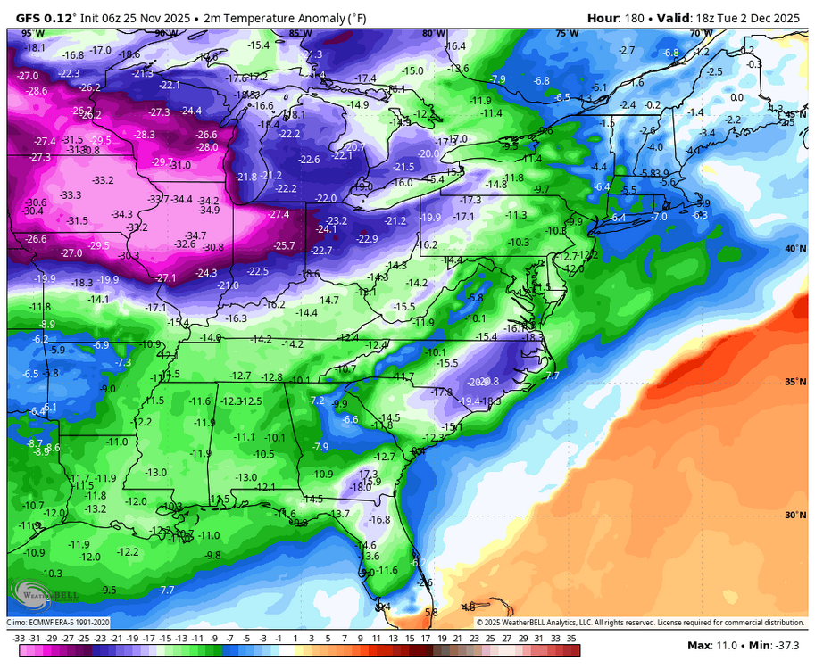
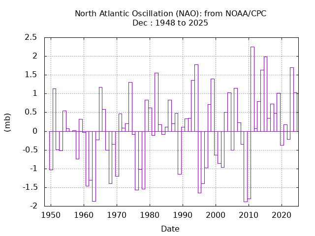
December has been one of the most challenging months for sustaining deep -NAO patterns since 2011.
-
Can’t argue with you. This is the time of year you want to hit your stride and start to peak. That ain’t the Eagles. Do they do anything well? You could say defense but now the injuries are piling up. The thing about the NFL this year is I don’t see any elite team, everyone looks beatable.
-
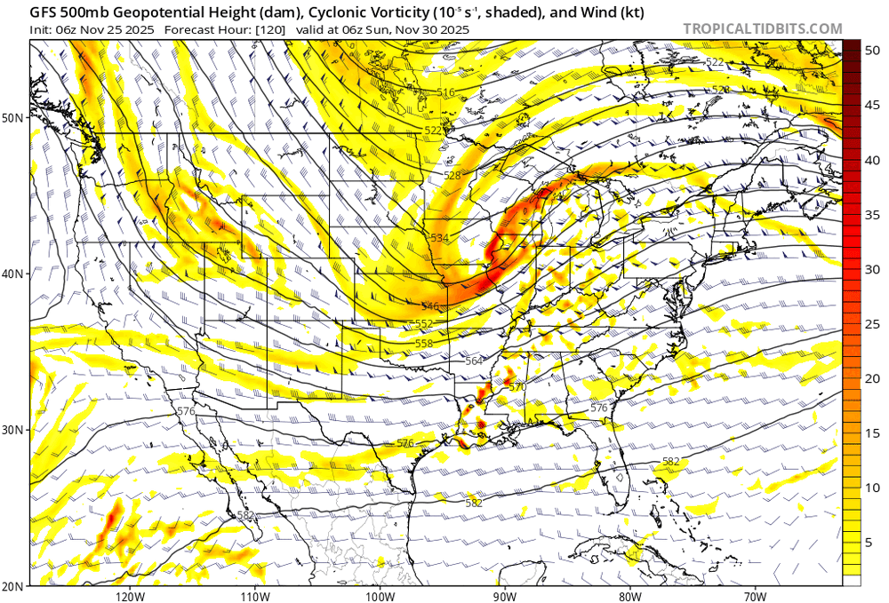
Check out this discontinuity between 0z and 06z on the GFS. That's day 5.
-

November 2025 general discussions and probable topic derailings ...
Torch Tiger replied to Typhoon Tip's topic in New England
without a more favorable pattern, looks unlikely. Unless you mean far nne (threats) -
November 2025 general discussions and probable topic derailings ...
Torch Tiger replied to Typhoon Tip's topic in New England
ensemble blends are fine to get a general idea /big picture
-
everyone should switch to Bluesky
-

November 2025 general discussions and probable topic derailings ...
CoastalWx replied to Typhoon Tip's topic in New England
It certainly opens up the door to good thermal gradient. And obviously yes, that powers storms. But with that comes some southeast ridge and then the storm track might get dicey. i’m just saying these are some of the things that I kind of see that perhaps are a little concerning to me, but I’m not writing off December or anything like that. It’s too far out to really determine that just don’t be shocked if all this snowy talk doesn’t exactly happen at least in southern New England. Probably will be a great December up north. One day we’ll sit back with a massive ridge out west where Calgary is 85 in December. I’ll sit outside and smoke a cjgar without a care in the world as the snow falls on my nude body. -

Nov 28-30th Post Turkey Day Wintry Potential
Baum replied to Chicago Storm's topic in Lakes/Ohio Valley
The early ride up the roller coaster is my favorite part. -
 The worries are beginning . Energy Mets on right track of Dec 1-15 of snow threats and then ending
 -

November 2025 general discussions and probable topic derailings ...
MJO812 replied to Typhoon Tip's topic in New England
No concerns yet. The models are horrendous in the long range. We should enter a mild period thought in mid December. -
Meteorologists, What are your current thoughts regarding the December 3rd system? Do we have a good shot at some early-season snow, and if so, what needs to occur for such an event to happen?
-

November 2025 general discussions and probable topic derailings ...
WinterWolf replied to Typhoon Tip's topic in New England
But wont that help us? I mean oresssine cold out weff go…And the big contrast in temps can produce some good baroclonicity? Or am I completely mistaken lol? -
November 2025 general discussions and probable topic derailings ...
Torch Tiger replied to Typhoon Tip's topic in New England
6z gefs milder in the extended. Canada is cold but more normal at end, with S US roasting. Concerns -
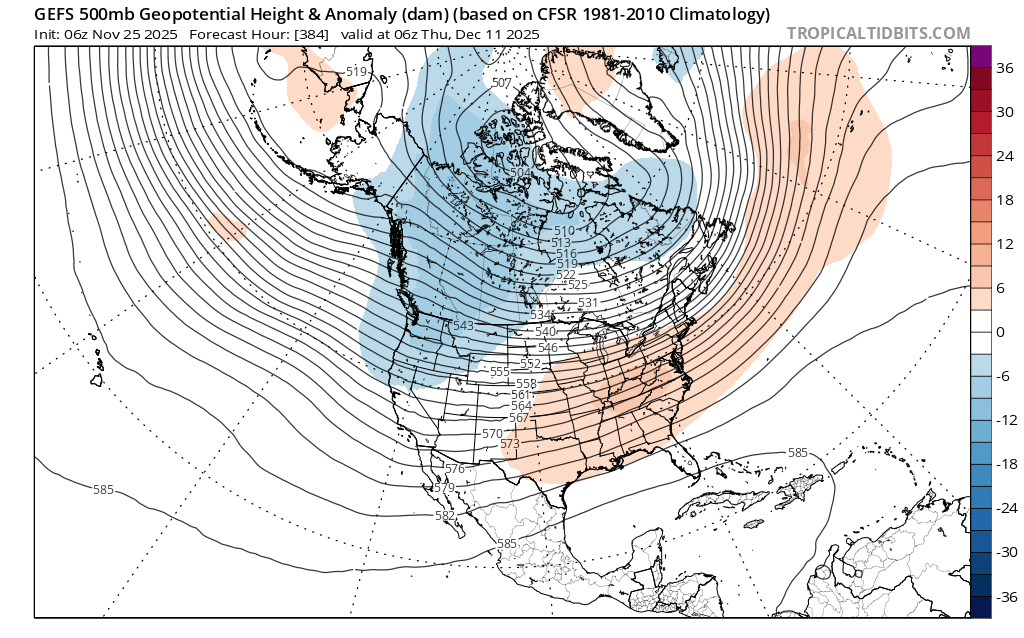
@40/70 Benchmark @Donsutherland1 @Bluewave They are finally admitting the obvious… “A stratospheric wave-reflection event is becoming more likely. Energy that had been expected to propagate into the stratosphere and weaken the vortex now appears more likely to reflect back into the troposphere. This often strengthens the Atlantic jet stream and can trigger a rapid recovery in the stratospheric vortex. This is likely why recent modelling has shifted toward a more zonal pattern compared with earlier expectations. If this occurs, and we see downward coupling from the stratosphere into the troposphere during December, then even with supportive background signals for blocking, stronger westerlies aloft could flatten the pattern and favour a more zonal setup significantly reducing the risk of sustained blocking or cold.”
-
November 2025 general discussions and probable topic derailings ...
CoastalWx replied to Typhoon Tip's topic in New England
What I was hoping to see was some -NAO to help sort of keep the PV further south. But without that we’ll probably be prone to cutters. Hard to tell at this point. I do think we’ll have chances unlike previous Decembers, but I wouldn’t plan on extended snow pack at least in southern New England. -
November 2025 general discussions and probable topic derailings ...
CoastalWx replied to Typhoon Tip's topic in New England
The PV will eventually migrate more to where it should be in northern Canada and cause a big temperature difference between the Canadian border and southern US. -
November 2025 general discussions and probable topic derailings ...
CoastalWx replied to Typhoon Tip's topic in New England
I think it’s helped with the Pacific side of things, but a lot of this action seems to be focused more in the stratosphere and not a whole lot in the troposphere. Overhyped as usual. -
I’ll buy an EV when they start offering the kind of EV I want to buy, right now the EVs marketed here in the US are either heavy, bulky high end luxury cars and trucks and SUVs, or ultra small economy compact cars. Where is the 4 door sedan (like a Camry) with the 250 mile range?
-
November 2025 general discussions and probable topic derailings ...
WinterWolf replied to Typhoon Tip's topic in New England
Question: doesn’t it take some time for any SSW affects to show up? Are we getting a PV split? Isn’t the big anomaly(PV) in SE Canada on modeling, a result of the SSW? Or no? -
1. No, ext for same run comes out a day later. —————— 2. GEFS 2 days ago: GEFS yesterday: gets to phase 8 five days earlier than any other GEFS as of then: GEFS today: curled back very slightly vs yesterday (E US cold lovers wouldn’t want a curl back into phase 7) but very similar to yesterday/look how different it is vs 2 days ago!
-
lol at using YouTube as a source for insightful scientific commentary the “soul” of science is the scientific method, saying “science has lost its soul” is pure emotion and has nothing to do with science
-
November 2025 general discussions and probable topic derailings ...
CoastalWx replied to Typhoon Tip's topic in New England
All the disrobing to wind reversals and it’s a neutral to +AO lol. Maybe it’s helped with the WPO area. But yeah just keep that cross polar flow coming. I told Ray I do see some signs of zonal flow so I feel like we’ll be sweating bullets at times. Guidance is already warming in the srn US. Let’s hope we average out to be more on the good side of things. -

Occasional Thoughts on Climate Change
WolfStock1 replied to donsutherland1's topic in Climate Change
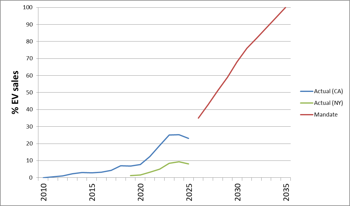
So basically two where EV sales are "out-competing": - Norway (super-cheap and easy electric via their natural setting for almost 100% hydro; sales boosted by subsidies) - Singapore (very wealthy and tiny; less than half the car sales of Iowa; sales boosted by subsidies) EV sales are certainly making progress (though now stalled in many areas), but I think you're overselling it a bit; especially given the subsidies that have been boosting them (thus my quotes around "out-competing"). As a point of US comparison - here's a chart showing the recent sales slump, and stalling of progress towards the CARB-mandated growth in 13 states, with the two key states of CA and NY shown: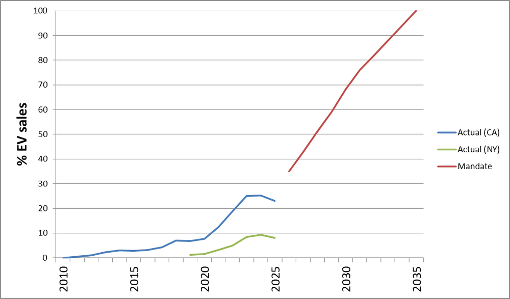
-
Winter sets in here late Weds or early Thurs morning, 20cm/7.9" Thursday alone is agreed from both WUN and TWN. For over a week its shown snow every day after that maybe 5cm or less from the lake. This is about the same time as winter starting last year just before the epic dump. I'll be glad to see this horrendous Nov in the back mirror, I much rather jump into deep winter with lots of snow. Today's dim light is my bane, its not dark enough to be cozy but not bright enough to cheer one up.
-
SER shifting SE. Modeling has certainly trended to colder outcomes in the East and the SE. .