All Activity
- Past hour
-

January 25/26 Jimbo Back Surgery Storm
NorthHillsWx replied to Jimbo!'s topic in Southeastern States
Idk, looks further north to me -
Yeah I try to urge people to give forecasters some grace because trying to get it right is much more difficult than they know, that the atmosphere is complex, and that sometimes weather does whatever the heck it wants, lol Mets are using their expertise to make the best prediction possible!
-
 I"m not sure why they don't adjust it....they have the ability to manually augment the precip if they think under catching is occurring. I agree those are definitely incorrect precip totals.
 -
Through 42…maybe a couple ticks better so far on the gfs.
-

Central PA Winter 25/26 Discussion and Obs
paweather replied to MAG5035's topic in Upstate New York/Pennsylvania
Thanks! I am hoping for something in between the floor and the ceiling 8-12”. Appreciate your thoughts @MillvilleWx -

Possible Record Breaking Cold + Snow Sunday 1/25 - Tuesday 1/27
Joe4alb replied to TriPol's topic in New York City Metro
-

Central PA Winter 25/26 Discussion and Obs
MillvilleWx replied to MAG5035's topic in Upstate New York/Pennsylvania
He was one of the best. My mentor in college. Learned so much from him that I still use to this day. His number one things he preached for a final forecast was “confidence”. When you make that final forecast, use wording that instills confidence for the consumer of the information. There’s always room to describe some uncertainty, but don’t wish-wash on something. Be bold. Never forgot that. -
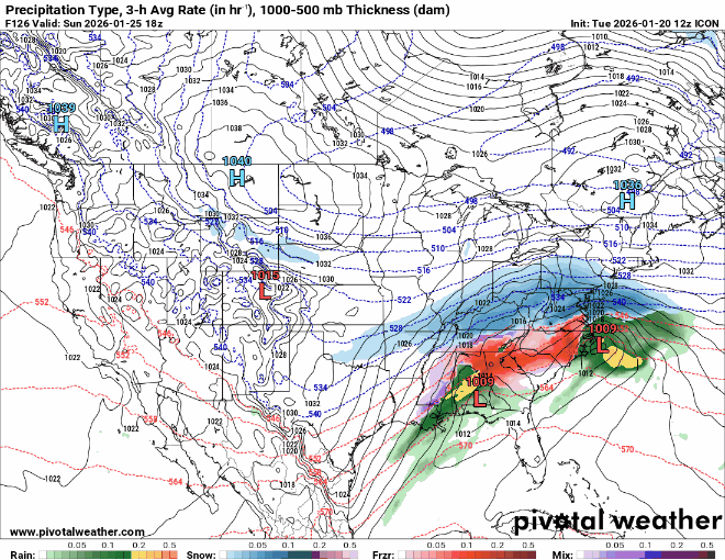
Did the ICON actually sort of back the time up to a little earlier compared to before (and to other models)? Seems that for awhile at least this was trending to more a Sunday-Sunday night (and possibly into Monday) thing.
-
 Icon is a bit south probably around 30 miles or so!
 -

MO/KS/AR/OK 2025-2026 Winter Discussion
stormdragonwx replied to stormdragonwx's topic in Central/Western States
To add to this, here's the SGF AFD Chat If its cold enough we may see 25:1 ratios. -
I don’t think it will be a complete miss at least
-
What has stuck out to me today is that there seem to be a pretty wide range of phasing scenarios that still give us a major storm. GFS skunked us because the northern wave was weak and the southern wave didn’t eject and there was no phasing. Seemingly any other combination of shortwave options is giving us SOMETHING. That to me is a major confidence booster that we’re not relying on perfect phasing or timing to get a snow.
-
Anyone got the fun maps for gfs
-
Central PA Winter 25/26 Discussion and Obs
MillvilleWx replied to MAG5035's topic in Upstate New York/Pennsylvania
Hey guys!! Still trying to gauge the Synoptics for this storm for PA. One fact is the ratios should be excellent and have the potential to breach 15:1 in areas away from the M/D. The key is where the 7H FGEN aligns. The EC output is what you want as that helps with the second part of the system and really gets the prolonged snowfall signature across much of the area through Sunday, even lingering into Sunday night. I think the bar is probably 3-6” for the floor, and 16-20” for the ceiling. Still time to parse details, but the one plus is it’s either gonna be snow or no at this point. It expecting mixing at all for this subforum! -
^WICKED^
-
Can’t wait to see what data gets fed into the models tonight and tomorrow. I have my pre op tomorrow at SOVAH Danville and I’m not even sure why anymore. Maybe I can get one of those sled dog teams from Greenland to get us all there Monday .
-
Damn it got me be a few seconds
-
I like my Sat night forecast- 80% chance of snow with a low of 13. Bring that shit.
-
I just send snow maps and say “it might do this, it might not, I’ll update later” and leave it at that haha but yes I agree completely. I have coworkers bash weather people all the time for being wrong and they don’t know I’m a weather nerd. Have to bite my tongue a lot
-
Rgem looks like it would have remained a smoke show if it kept going.
-
-
Fwiw 18z Rgem was not only bringing the Baja vort out but it was looking pretty phased with the N stream at 84hrs. Precip shield looked very similar to the 12z Ggem too.
.thumb.png.673cac003c868b2299e06ee10bc4359c.png)
-
Indeed. A fear for northern areas for sure. While the northern crew was gallivanting in oodles of snow in Feb 2014, we lowlanders were getting spittle and dryslot. Different storm, but I like when I see that 32 degree line well SE of me
-
Central PA Winter 25/26 Discussion and Obs
paweather replied to MAG5035's topic in Upstate New York/Pennsylvania
@MillvilleWxyour thoughts for us in SC PA? -
Honestly...half the neighborhood is asking me or asking my wife to ask me about it (just like the bus stop moms). I'm pretty involved in the community, so folks know they can ask me about it and I'm happy to engage, but the whole "Meteorologists have the easiest job" crap gets under my skin.


.png.eb3176a4698c2fe942450b35fde98cf5.png)


