All Activity
- Past hour
-
Nice and picturesque? More like miserable and dreary with a cool snowy blast. 3 hours now of 30° drizzle kinda sux. 2 blockbuster storms, plenty of "real" cold and snowcover for almost 3 months made it a pretty damned good winter. I'm done with it
-
RGEM NAM and the GFS like the ice storm Thursday night into Friday..
-
Light zr and 29. Roads are slick from the previous snow/sleet with a layer of ice on top.
-
FYI, I was emailing with David Robinson, the NJ State Climatologist about New Brunswick snowfalls and he said that the March 1888 blizzard was 36" (estimated) in NB. Obviously data from that long ago can be a bit iffy, especially with the reported very high winds and drifting, but that's well out of range with what you have for CNJ, like the 21" vs. other much higher reports in NYC. This is one of those storms where a 20-36" swath might be more appropriate.
-
Yup…Definitely that area in Mass/Springfield, always a minimum there, but just bad luck for Middlesex county in CT this year for them.
-
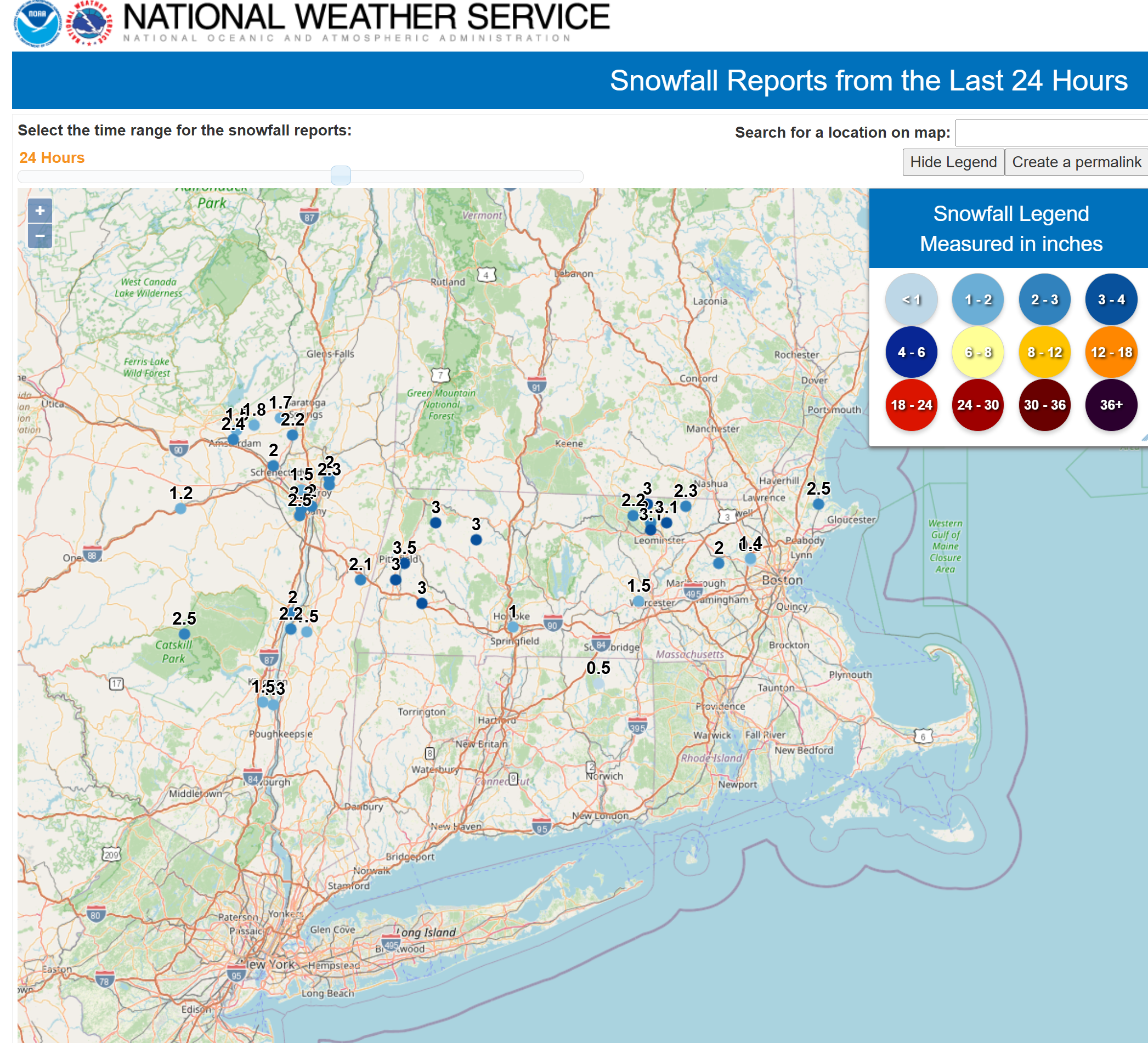
2.5" over the course of the day. The first half inch was snow on snow only. Now pinging
-
You do you I do me
-
Just measured 3" in Lowell. We had aggregates for about 5 minutes, but back to moderate snow.
-
So dumb
-
Love this . Let them have the fluff
-
Ayer, MA
-
what town is this?
-
4” here. Much lighter. Smaller needles and such.
-
Unbelievable. Anutha one...
-
S est vis 1/2 mi 3.5" 27 f
-
This winter?…. Seems to happens every winter. That has to be the absolute worst area for snowfall in SNE north of the canal. I hated my 4 years in Amherst regarding snow. Constantly the lowest numbers in every type of storm
-
Potential around St Patty's day. Pretty good h5 look esp for mid March. A lot would have to break in our favor, but probably the next(last?) chance.
-
If we can get some snow this weekend in 70+ temperatures, you will be in great shape.
-
We need batches of precip like this in January. Would be an easy warning level event.
-
Yup, the snow gods had some fun with you yesterday. The 0.4 at IAD was reported yesterday afternoon, but this morning we woke up to find that was it there, whereas DCA checked in at 0.8. However, another 0.5 at BWI could still win it for you.
-
Down to light snow now.. I bet that next band to the west changes us over to sleet
-

Central PA Spring 2026 Discussion/Obs Thread
canderson replied to Voyager's topic in Upstate New York/Pennsylvania
It was a very dry meteorological winter (Dec-Jan-Feb). Some of our long-term climate stations cracked the top-ten of their driest winter seasons (Dec 1st-Feb 28/29th). Station Total Precip Rank Period of (inches) (Driest) Record (since) ------------ ------------ -------- -------------- Altoona 4.15 5th 1948 Bradford 4.25 2nd 1957 Harrisburg 6.05 17th 1888 Johnstown 4.93 3rd 1892 Williamsport 5.24 15th 1895 State College 4.52 8th 1893 -
Should the AO stay positive, it will probably be a one-week or so window of opportunity. If, however, blocking develops, then the probability of a multi-week cold period would increase. Hopefully, we can get a decent storm during the window of opportunity.
-
Huge aggregates. You can see it on dualpol. Never noticed this specific one: https://weather.cod.edu/satrad/nexrad/index.php?parms=BOX-HHC-1-24-100-usa-rad
-
Central PA Spring 2026 Discussion/Obs Thread
canderson replied to Voyager's topic in Upstate New York/Pennsylvania
No ice anywhere for me when I left the hose at 8:30 this am. I did hear sleet around 6 am falling.