All Activity
- Past hour
-

February 2026 Medium/ Long Range Discussion: Buckle Up!
yoda replied to Weather Will's topic in Mid Atlantic
Unfortunate on the 12z GFS on the 15th -

Is we back? February discussion thread
Damage In Tolland replied to mahk_webstah's topic in New England
Night moves? -
Yep. Some of my favorite winters 79/80, 81/82, 86/87, 95/96, 09/10, 10/11, 13/14 and 24/25. Why? Because they ALL had a minimum of 30 days of at least an inch OTG at 7 am.
-

WxUSAF's weak ass frontal passage thing.
stormtracker replied to dailylurker's topic in Mid Atlantic
I'm at 34 in Mount Cleveland Park. High is supposed to be 35. We all gonna bust on temps today. -

Central PA Winter 25/26 Discussion and Obs
Itstrainingtime replied to MAG5035's topic in Upstate New York/Pennsylvania
Correct. My station only receives sunlight during late afternoon hours during peak sun angle season. During the winter months it's shaded 24 hours a day. -
Central PA Winter 25/26 Discussion and Obs
Itstrainingtime replied to MAG5035's topic in Upstate New York/Pennsylvania
My temp is 35.3 currently. There's a wunderground station near Rheems that is at 38, most in my area are between 33 and 36. -

Fall/Winter Banter - Football, Basketball, Snowball?
GBOVolz replied to John1122's topic in Tennessee Valley
Not in our area but thought I’d share these pictures from a fire at Elm Hill…Percy Priest lake in Nashville. Mt Juliette area. . -
Think you’re in a decent spot to get something from this
-

Pittsburgh/Western PA WINTER ‘25/‘26
colonel717 replied to Burghblizz's topic in Upstate New York/Pennsylvania
Both GFS and CMC are advertising back to back decent clippers Friday and Sunday. Could be several inches between them both. -

WxUSAF's weak ass frontal passage thing.
NorthArlington101 replied to dailylurker's topic in Mid Atlantic
Not sure any model nailed the temp bust today. My theory would definitely be overdoing the effect of the snowpack. I'm hoping the Capital Bikeshare bikes can be freed from their glaciers soon so I'll root for some melting. -

Central PA Winter 25/26 Discussion and Obs
pasnownut replied to MAG5035's topic in Upstate New York/Pennsylvania
actually something that i think is a valid point to consider, as it makes sense a sheltered location vs one sitting in wide open would likely show notable diff. I'm guessing our weenies know this and put them in areas less affected by direct/indirect sun. -

Is we back? February discussion thread
40/70 Benchmark replied to mahk_webstah's topic in New England
He'll start slowly...maybe take a night shift. -
Is we back? February discussion thread
40/70 Benchmark replied to mahk_webstah's topic in New England
I spent a lot of time shaved in the corps, but it's ultimately just not for me. -
Central PA Winter 25/26 Discussion and Obs
pasnownut replied to MAG5035's topic in Upstate New York/Pennsylvania
Is it over..... You callin it ?? hehe -
Is we back? February discussion thread
Damage In Tolland replied to mahk_webstah's topic in New England
Working with Vortex95?? -
Central PA Winter 25/26 Discussion and Obs
pasnownut replied to MAG5035's topic in Upstate New York/Pennsylvania
not sure we have a true split flow regime setting up in long term. More like a zonal (which at time can have NS/SS playing together (time dependent). But to answer your question, with a split flow, Its all about the boundary and what side you're on w/ respective vort pass. Longer lead zonal sorta fits tellies and upper air IMO. Remember that there are other signals, MJO/SSW that have lag time effects on long lead models, so one has to keep that in mind when seeing a model output and high fivin...or kickin stones. That said, next week may look notably different at this time. Thats all I'm sayin. We have another week of winter until we get our annual thaw, and in truth, we've had a great run despite the NS overwhelming the east, and pushing that precious boundary too far south and given NMA/Carolinas our precious snow. A true snow hound knows you gotta be close to the rain for the best snows, and thats been way far south. Bring a zonal pattern, and keep SS vorts from diggin too much (cutters) and just need to be close enough to the cold for some more chances at precip of the hopefully frozen variety. Of course if that happens, we'll likely be on warm side for some. it's how things roll. Just hope for the follow up waves to be further south. -
12z GFS...

-
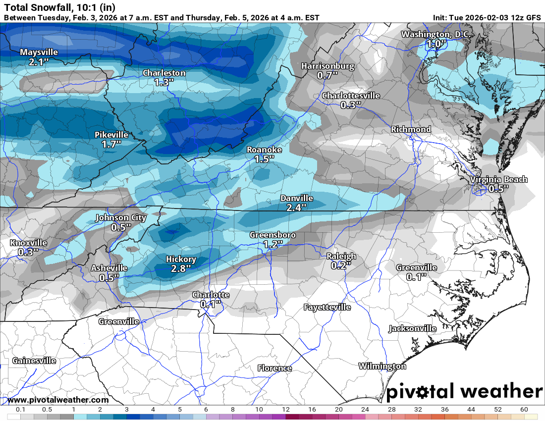
12z CMC solid for southern Va
-
Nice man isn't this awesome. We wanted it for 3 winters.
-

February 2026 Medium/ Long Range Discussion: Buckle Up!
BristowWx replied to Weather Will's topic in Mid Atlantic
yeah. But its pushing near 50F on the 2m map. on the 11th. just a point of interest. for a headline like that you would think sub 500dM thickness is in the offing. its 552. long way off. who knows. -
Yes it was either 6 by 2 or 4 by4 he went 4 by. God willing he never goes back
-
Not happy that the cloud cover disappeared completely. But oh well. It's been either absolutely clear or cloudy. Never in between. lol Be nice to be mostly cloudy on these warm days. Meh.
-

WxUSAF's weak ass frontal passage thing.
SnowenOutThere replied to dailylurker's topic in Mid Atlantic
I think I'll hit 50 pretty easily. Might be time to try to break my bike out of the glacier. -
I love bald dude lol Come to GTG
-
That's does it... Man..don't send pictures of what you look like... Now I can't take anything you say seriously... ( JK ). Bald is beautiful!!! Own it!!