All Activity
- Past hour
-
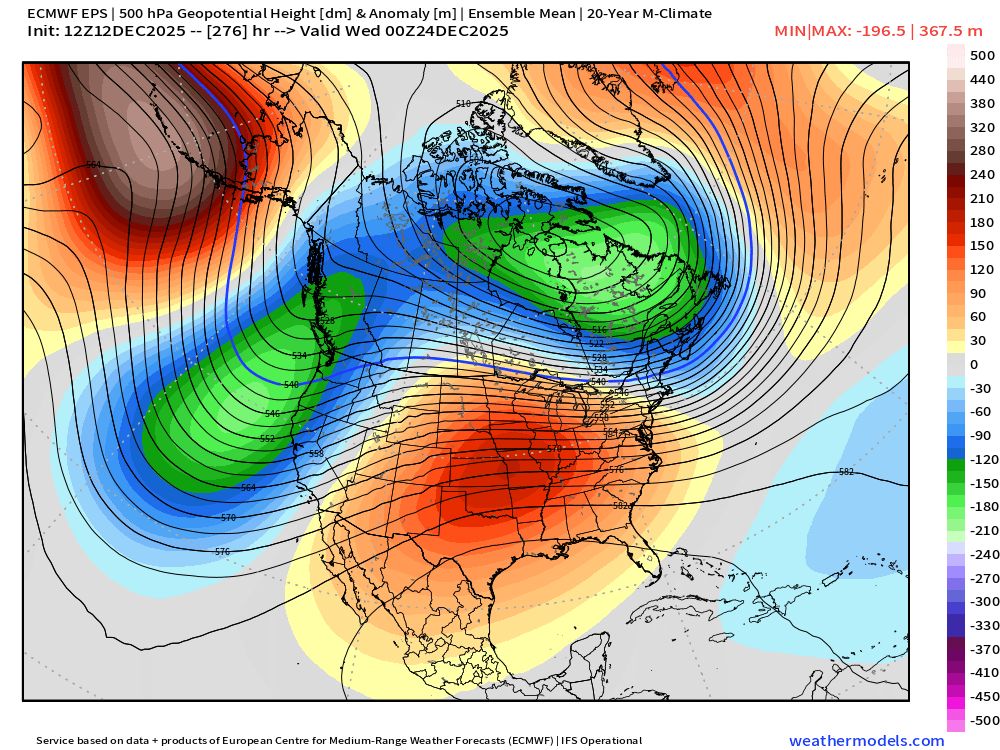
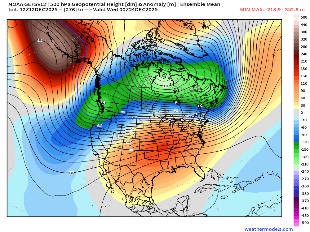
Probably assuming the cutter is real. Still some disagreement but I’d be shocked if we didn’t get at least one very mild day. Sunday’s event is just for aesthetics for a few days…we’re gonna need something in the 12/22-12/25 range to get the White Xmas…and it’s possible we could get that…ensembles have been coming around to the idea of overrunning/SWFE potential when looking at the H5 anomalies heading into Christmas Eve.
-

December 2025 regional war/obs/disco thread
TauntonBlizzard2013 replied to Torch Tiger's topic in New England
AI Euro has an event in that timeframe too, looks marginal temp wise though until you get to CNE -

Minor snow possible sunday 12/14/25
hooralph replied to WeatherGeek2025's topic in New York City Metro
It all ends under cloudy skies as you cling to the idea that this time, the Norlun trough will deliver. -
True kiss of death on a return to colder pattern is the cold air in Canada getting washed out, dont see any signs as of now.
-
We can only hope. Upper 40s, low 50s I can stomach. I just hope we aren't stuck in days on end where our low temps are above our average highs. I'm talking about the coldest time of the year, lowest sun angle. I just loathe 60s this time of year. It's unnatural.
-

Minor snow possible sunday 12/14/25
CentralNJSnowman replied to WeatherGeek2025's topic in New York City Metro
"This is the hardest I've seen it snow in years" - typically posted about every 2-3 weeks during the winter, anytime rates exceed one inch per hour -
I’d love to see the precip expanded all the way to short pump to feel good about this one. If it did that then NE MD can get PUMMELED
-

12/14: Sunday funday? Will the south win again?
NorthArlington101 replied to TSSN+'s topic in Mid Atlantic
sorry one more EPS post - this is the median. While the ens are obviously less dispersive so close in, it's still nice to see they very strongly agree with the OP (as opposed to yesterday where the 3-5" 12z EURO run was an outlier of outliers) -
yeah i'd say Jan 15 - Feb 15. Similar to how July 15 - Aug 15 is the most miserable part of summer lol.
-

December 14th - Snow showers or Plowable snow?
ORH_wxman replied to Sey-Mour Snow's topic in New England
I think outside of the NAM (which is prob safe to ignore for now…maybe by 00z it starts be more useful), the 12z suite was enough to at least give a 1-3” floor for the south coast/Cape. Hopefully we can inch this a little further north. -
Call me old fashioned, but I love the 00z/12z runs during northern stream events because their have upper air data incorporated into them.
-

December 2025 Short/Medium Range Forecast Thread
Carvers Gap replied to John1122's topic in Tennessee Valley
Same feedback error IMHO as ~ three weeks ago. Two different models - still trying to figure out why there is so much feedback over the West during the past month. Here is the Euro at 264. That mid-continent ridge doesn't get pumped without that area of BN heights which has tracked from Calgary into the Pacific (yes, you read that correctly). Here are the two timeframes.... -
Yeah 12z euro gives most of New England a nice event on Xmas eve (maybe starting overnight 12/23)…high end advisory and then frigid Xmas day.
-
We’ve been hammered up here in the western Avery high country. 17 inches so far and plenty of days with snow on the ground. Solid snowpack right now.
-

December 14th - Snow showers or Plowable snow?
WinterWolf replied to Sey-Mour Snow's topic in New England
Now that’s what we like to hear brotha. . Good post. -
Prime climo for the region isn’t until mid/late Jan.
-
Really nice 12z suite
-
It might work out, it might not. I have 70/30 fail to win ratio. Until it starts we just won’t know
-
I was reading about that. I love Wisp. By far my favorite ski resort
-
I think it’s clear now that a warmup is coming and probably average AN from the 17-18th through the Xmas week. But with abundant cold air in Canada, I think it won’t be wall to wall AN days (like we’ve had BN days the last 2 weeks), and not impossible to slip in a winter precipitation event with good timing luck.
-
How warm isn't really the problem imo. It may be just run of the mill +3-5 departures and not really feel "warm". The issue is the longwave pattern and what it means for storms. Ensembles universally agree on a persistent -pna with low heights in the GOA and PacNW area and a positive AO/NAO combo. That pretty much kills snowstorm chances. The only path would be backdoor cold fronts/CAD and it's a stretch to get things right for a snowstorm without some kind of block. A transient 50/50 could work but that's threading the needle and most certainly not something we can track at long ranges. Tracking temp departures isn't something that excites me lol. I like to track snow chances exclusively and I'll need to concentrate on other hobbies for a while. I'm probably in the minority but if the upper level pattern is super hostile for snow chances, I'd prefer it to just be warm and dry lol
-

Minor snow possible sunday 12/14/25
sussexcountyobs replied to WeatherGeek2025's topic in New York City Metro
-baby steps -this model is terrible in this situation -this looks like _fill in favorite weenie storm Some good wrap around/back end snow. -
12/14: Sunday funday? Will the south win again?
NorthArlington101 replied to TSSN+'s topic in Mid Atlantic
It's probably past time to look at the EPS but this is notably more generous/widespread than 06z, fwiw. -
Giggity
-
Looking at the long range of an operational model lmfaooo


