All Activity
- Past hour
-
88/76 at 8a is just cruel. I’m completely drenched waiting for the bus to the office.
-

July 2025 Obs/Disco ... possible historic month for heat
Damage In Tolland replied to Typhoon Tip's topic in New England
South trend -

July 2025 Obs/Disco ... possible historic month for heat
weatherwiz replied to Typhoon Tip's topic in New England
Absolutely beautiful outside. Already feel the process of my body beginning to produce sweat. There is nothing like feeling the hot, strong sun beat down on you and the tingles you get when the sweat producing process commences. I mean this is gold, everyone loves it. The birds are happy, praying mantis are happy, people have smiles on their faces. Feel it, embrace it, love it. -

July 2025 Obs/Disco ... possible historic month for heat
Typhoon Tip replied to Typhoon Tip's topic in New England
Looked to me like the whole blend bumped S a little bit. That may not be caused by repositioning the track of that frontal mess, per se. It could also be an artifact of that amplitude flattening - a problem we've discussed ad nauseam in the past, where the models sometimes have trouble maintaining mid/ext outlook amplitude when relaying into short ranges. Hard to tell precisely, as this scenario with rain/amts on Thur/Fri looks pretty sensitive to very subtle physical perturbation, anyway, so - I just see the 00z UKMET type solution as not impossible at least in principle. It may be overdoing that suppression some sure. -
The GFS and Euro doesn't have us above 90 again after Thursday until August 10th. I'd count that as a win.
-
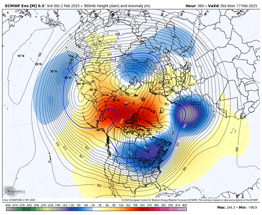
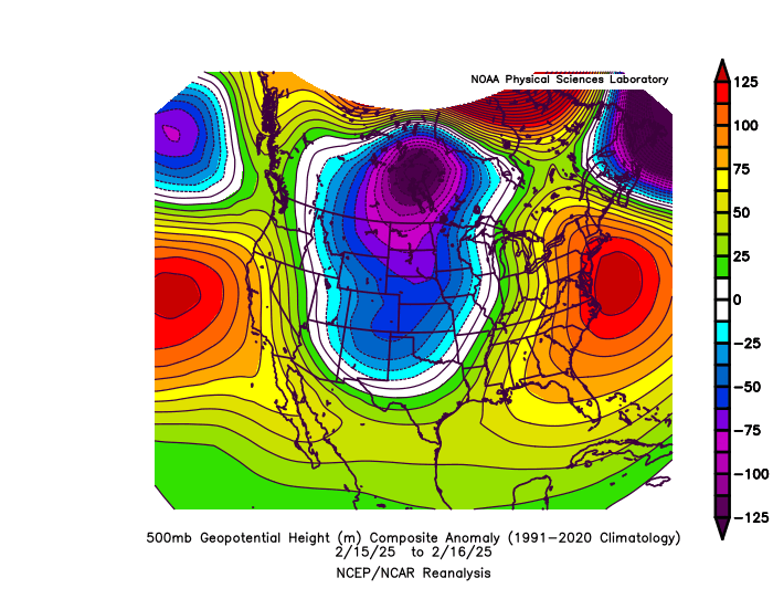
The ECMWF seasonal forecast system from before the winter missed the +PNA mismatch that I was discussing the potential for last October with the early MJO indicator. So the long range forecasts from months like October were obviously too warm since it missed the correct 500mb pattern. But in previous years without a mismatch, the seasonal model was too cold from October for the 22-23 and 23-24 winter forecasts. It missed the record warmth both winters from the fall seasonal forecasts. Now the 2nd way the Euro was incorrect last winter involved the medium term 15 day EPS. It was too cold overall in the Northeast but did better in other parts of the country. The 500 mb long range pattern forecast for February missed the Southeast Ridge linking up with the -5 AO in mid-February. It had a classic KU look around the time of the big -AO drop. We wound up with the storm cutting west of the big cities leading to the record snows in Toronto and Montreal. In the past we didn’t get these Southeast Ridge linking ups with such strong blocking near -5 SD around Greenland. The model actually did a very good job at the higher latitudes. But missed the subtropical ridge amplification. This is why the heavy snows it had around NYC in the longer range forecasts wound up significantly further north. This has been the case since the 18-19 winter with the big snowstorm always being 8-15 days away. The GFS and CMC have had the same issue so not so not just singling the Euro out. But it’s the highest scoring model overall so it gets more attention. The charts below represent a repeating model error or bias since the 18-19 winter. EPS long range forecast had the classic KU look but missed the strong Southeast Ridge amplification leading to the first February cutter for a -5 -AO
-

July 2025 Obs/Disco ... possible historic month for heat
BrianW replied to Typhoon Tip's topic in New England
Yeah. Was working on a house near BDR last week and everything is torched to a crisp there..thumb.png.c49f6f72b67ae771aa8015504e677abf.png)
-
A dry spot wandered by here and dropped my DP to 71. AAFB is with us at 72, but KNAK is 77. Low temp was 73.
-

2025-2026 ENSO
40/70 Benchmark replied to 40/70 Benchmark's topic in Weather Forecasting and Discussion
Yes, no argument there. Last season was a glaring deviation from the norm in that respect. -
Did you play that Banff Springs golf course? Played that many times over the years on various golf games.
-

Central PA Summer 2025
Mount Joy Snowman replied to Voyager's topic in Upstate New York/Pennsylvania
Alright, I don't have access here at work to the site I would normally prefer for this type of question, but I used some other sources and can at least say the following with regard to MDT.... July should end up ~80.0, which, when combined with June's 73.8, should get us close to 77. 2024 immediately stands out as the GOAT with a mean June/July temp above 78 degrees. Then there are a number of other years slightly above that 77 mark. So, no I wouldn't say it's the hottest start ever, but yes I would say it's one of the warmest starts, top 5-10ish. Depending how August goes, it has an outside chance of making a run at the Met Summer record. -
Picked up 0.15" anvil rain/ISS early this morning. Up to 5.42" for July now. As of yesterday MLI/DVN was at 8.74"/8.21" for July.
-

July 2025 Obs/Disco ... possible historic month for heat
SouthCoastMA replied to Typhoon Tip's topic in New England
eh, so much for the Cotuit/Wareham CCBL game I was going to on Friday -

July 2025 Obs/Disco ... possible historic month for heat
Brian5671 replied to Typhoon Tip's topic in New England
Looks run of the mill now on most models....although we can use any rain we can get here-very dry -
Yes, surprisingly for once it was too warm. Other that that lone exception, the long range modeling has been too cold in the east for almost 10 years now
-

July 2025 Obs/Disco ... possible historic month for heat
CoastalWx replied to Typhoon Tip's topic in New England
Someone is getting hydro Phil. -

July 2025 Obs/Disco ... possible historic month for heat
kdxken replied to Typhoon Tip's topic in New England
It's a weird one. -
July 2025 Obs/Disco ... possible historic month for heat
kdxken replied to Typhoon Tip's topic in New England
I wouldn't want to be a forecaster trying to figure out how much rain we're actually going to get. -
.thumb.png.4150b06c63a21f61052e47a612bf1818.png)
July 2025 Obs/Disco ... possible historic month for heat
HIPPYVALLEY replied to Typhoon Tip's topic in New England
CMC also likes to give us lots of snow in the winter. -
I seriously had to look several times because I know that we were in deep purple, but it's intriguing that the map seemed to have updated it even after you copy and pasted it. They definitely lowered rainfall totals in the range of 1 to 3 days. I could still use an inch though.
-

July 2025 Obs/Disco ... possible historic month for heat
ineedsnow replied to Typhoon Tip's topic in New England
0z CMC had a weak tropical system.come up? Lots of rain - Today
-
July 2025 Obs/Disco ... possible historic month for heat
ineedsnow replied to Typhoon Tip's topic in New England
Models backed off a bit.. Euro is still fun though.. let's see what 12z brings -
July 2025 Obs/Disco ... possible historic month for heat
CoastalWx replied to Typhoon Tip's topic in New England
What smoke -

July 2025 Obs/Disco ... possible historic month for heat
NoCORH4L replied to Typhoon Tip's topic in New England
Hopefully it's like Leominster Round 2, but a little further west. -
That's not the map I originally posted. Its the updated one. I did a copy/paste, so I guess it links. They have definitely been making some adjustments.


.png.fa9a2dc91a2328590bc6ee2ea48bfc6f.png)


