All Activity
- Past hour
-
A nice, easy warm advection snow event would be the best. No mixing, just cold powder.
-

Richmond Metro/Hampton Roads Area Discussion
mikeeng92 replied to RIC Airport's topic in Mid Atlantic
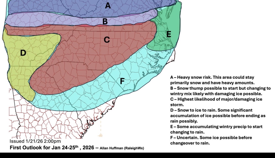
From Allan Huffman
-
If it's going to be ice, we can only hope QPF drops off as well. Anything to prevent major accrual.
-
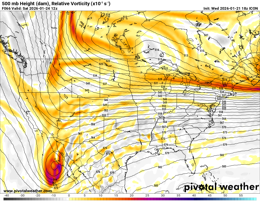
The ICON looks like a step in the right direction through 72, with more spacing
-
Seems like PM guidance is trending more toward MA and N CT. Either way looks like a C-1” deal. Maybe a spot 2” for someone if they get lucky.
-
That’s what we want
-

January 24-26: Miracle or Mirage JV/Banter Thread!
mappy replied to SnowenOutThere's topic in Mid Atlantic
Not surprised. It’s been quietly talked about all week -

January 24-26: Miracle or Mirage JV/Banter Thread!
mitchnick replied to SnowenOutThere's topic in Mid Atlantic
With virtual an option, probably longer than they need to. -

Central PA Winter 25/26 Discussion and Obs
canderson replied to MAG5035's topic in Upstate New York/Pennsylvania
Extrapolation says game on -

E PA/NJ/DE Winter 2025-26 Obs/Discussion
RedSky replied to LVblizzard's topic in Philadelphia Region
A couple -

January 25-26 Winter Storm Potential
Hurricane Agnes replied to Ralph Wiggum's topic in Philadelphia Region
18z 12k NAM last frame shows the beginning of it.
-
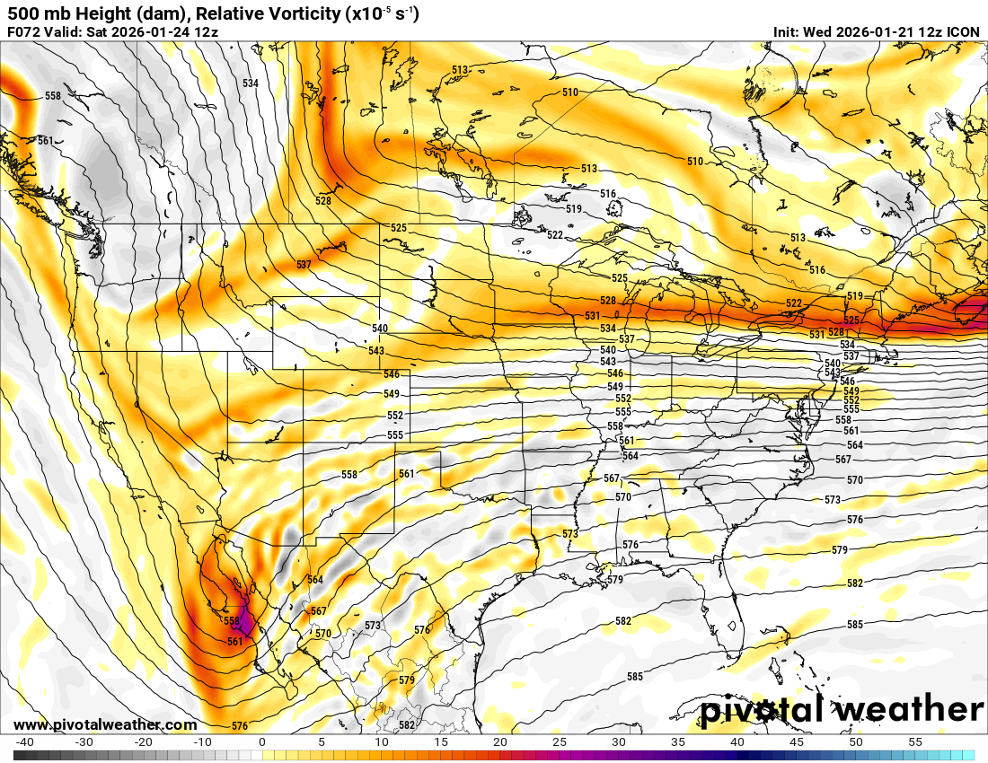
I'll let someone more qualified than me comment on meaning, but here's ICON 18z (top) versus 12z (bottom). Valid Saturday 12z. Baja wave looks more organized and more positively tilted. Northern stream energy has a different position too
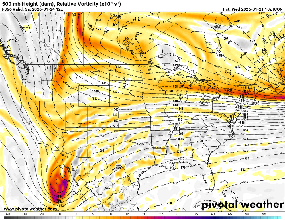

-

January 24-26: Miracle or Mirage JV/Banter Thread!
Ralph Wiggum replied to SnowenOutThere's topic in Mid Atlantic
Is this the gooning thread for the weekend? -

January 24-26: Miracle or Mirage JV/Banter Thread!
ErinInTheSky replied to SnowenOutThere's topic in Mid Atlantic
Question… if the biggest hit scenarios are what we get in MoCo, how long would schools be closed for? I have never experienced a snowstorm like this despite living here 10 years. -
ICON is also a touch flatter out front
-

January 24-26: Miracle or Mirage JV/Banter Thread!
AlexD1990 replied to SnowenOutThere's topic in Mid Atlantic
local hardware stores on FB saying they're out of rock salt already, lol -

Possible Record Breaking Cold + Snow Sunday 1/25 - Tuesday 1/27
Wxbear25 replied to TriPol's topic in New York City Metro
Icon wants to send the S/W in the Southwest on a vacation in Cabo -
I think your on to something a mid range model by combing the GFS and the NAM OH DEAR GOD NO
-

January 25/26 Jimbo Back Surgery Storm
Brick Tamland replied to Jimbo!'s topic in Southeastern States
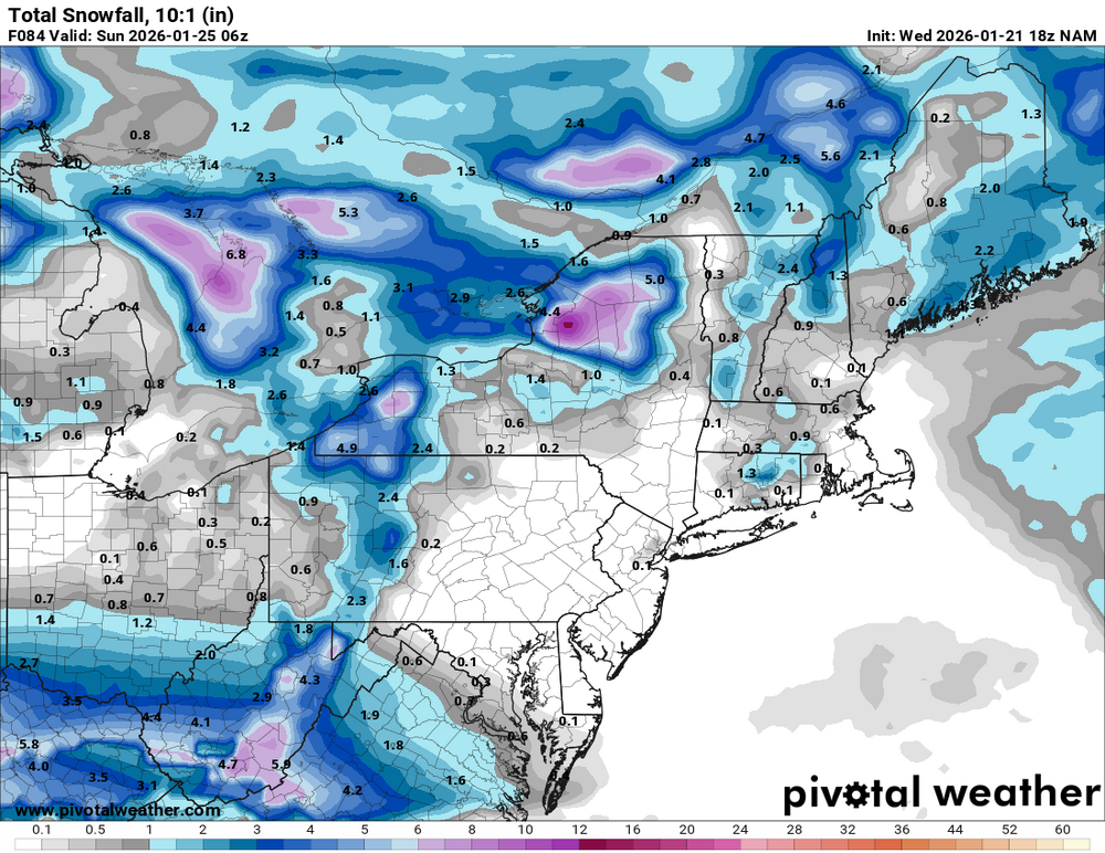
End of the NAM. At least it's more sleet than freezing rain. -
January 24-26: Miracle or Mirage JV/Banter Thread!
AlexD1990 replied to SnowenOutThere's topic in Mid Atlantic
legit LOL'ed
-
18z icon seems to follow the nam trend of going back to the overrunning type system vs the amp'd solution
-
 I definitely understand, Parts of Long Island could flip to sleet unfortunately, even NYC. I am mostly basing my forecasting off GFS and especially Euro AI. plenty of time still
 -
January 24-26: Miracle or Mirage JV/Banter Thread!
mappy replied to SnowenOutThere's topic in Mid Atlantic
Alena has mentioned it in the mornings since Monday. Ava and Tommy T went into it more last night. Showing ensemble percentages and such. 4pm news started with Tony giving the aleet haha usually 415ish when they do their first wx segment. Doubt they mention actual totals -
One thing that I'm noticing is that the models with a stronger 850 low in the central US are the ones that are able to drive it up to Cleveland and eventually draw up the warm sector for us at the end of the storm. The GFS does not do that, with a weak 850 low that is eventually replaced by a new low that forms off of Cape May, NJ.
-

E PA/NJ/DE Winter 2025-26 Obs/Discussion
Birds~69 replied to LVblizzard's topic in Philadelphia Region
Notice that an hour ago. It did get cloudy and darker to the W but nothing yet. Should be entering my area soon...