All Activity
- Past hour
-
I’m surprised to be included in the watch
-
New season new underperforming PSU football. Sorry for the banter.
-
the more I look, you should get a good soaking. more worry here, but id take the HRPES or 3K NAM in a sec
-
Just SVR now
-
Severe Thunderstorm Watch for SE counties in CTP.
-

Saturday 9/6 Strong/Severe storm potential
Damage In Tolland replied to Torch Tiger's topic in New England
Will they Tor watch? -
-

-
Your outlook was good.
-

September 2025 OBS-Discussion centered NYC subforum
SACRUS replied to wdrag's topic in New York City Metro
-
Sunny, 82/74 Great pool day, hoping Stein protects us here in TBlizz land
-
I came in here just to ask this! It filled in like some late evening fog / humidity will sometimes (usually in clear air mode) but it’s in precipitation mode. It’s accurately showing the rain to the NW… nothing wrong with the radar it would seem, unless the software isn’t filtering out stuff like it usually does. There is motion / waves to it that reflects what moisture in the atmosphere would be doing - just not sure why it’s only visible around IAD / the radar.
-
25 and snow 3 months from now while Kevin throws his laptop out the window after seeing your post.
-

September 2025 OBS-Discussion centered NYC subforum
Brasiluvsnow replied to wdrag's topic in New York City Metro
I just looked at the radar ps New City Rockland County checking in and I see a few things popping up as I type just to my west ,,,,,I hope it holds off until tonight -

Saturday 9/6 Strong/Severe storm potential
DavisStraight replied to Torch Tiger's topic in New England
It's a mile from my house,, yes in York for good -
Are you in York now?
-

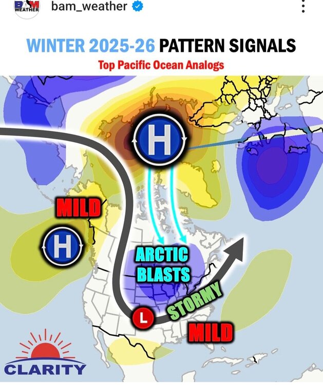
2025-2026 ENSO
michsnowfreak replied to 40/70 Benchmark's topic in Weather Forecasting and Discussion
Not sure about MUCH warmer than normal, but overall warmer than normal wouldn't surprise me at all. It actually fits perfectly with your expected nina. A mild Fall with a sharp turn colder in late November or early December is classic nina. The caveat of course is that "warmer than normal" comes with rapidly cooling averages. Not sure how far south this applies, but for here at least, even a warm October is far from hot. A few days of low humidity 80s and a few frosts normally happen in warm Octobers. -
That place is cool
-
Saturday 9/6 Strong/Severe storm potential
DavisStraight replied to Torch Tiger's topic in New England
I may go to the top of Mt Agementicus -
department of west atlantic ridges
-

September 2025 OBS-Discussion centered NYC subforum
Picard replied to wdrag's topic in New York City Metro
We need the southern part to develop right. It did the other night. These set ups are always a bit iffy to me, I always tell people to watch for things popping up, but not to plan their day around it. -
2025-2026 ENSO
michsnowfreak replied to 40/70 Benchmark's topic in Weather Forecasting and Discussion
They are very biased towards enso and also biased towards a warmer climate. That is why periods of cold are never seen far out, you will see them grow colder as the timeframe nears. -
2025-2026 ENSO
michsnowfreak replied to 40/70 Benchmark's topic in Weather Forecasting and Discussion
1000%. I can't speak for the east coast, but here in Michigan it absolutely would have snowed more synoptically if it wasnt as cold and dry as it ended up. It snowed nearly every day for long stretches much of winter, yet we finished over a foot below normal. That is as anti "new climate" as you can get. -

September 2025 OBS-Discussion centered NYC subforum
MANDA replied to wdrag's topic in New York City Metro
Certainly what is on radar now is moving briskly along to the NE. Not like the other night with slow moving training batches of rain....at least so far.


