All Activity
- Past hour
-
A lot will depend on how shallow the airmass is of course with the CAD in place. What we have going for us is the fact that there will be a parent high to begin with. The players are there for sure in looking at the models but as always we need everything to line up perfectly for blockbuster snows. We will see how this plays out. Even if there is some mixing I always remind people that 1/25/00 started off with many hours of rain before the massive snowfall.
-
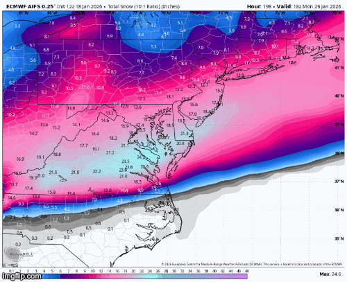
Euro AI: our savior, strong and unwavering
-
No
-
Time to start the thread?
-
You mean euro ai? Never heard of euro surface temps being broken.
-

Central PA Winter 25/26 Discussion and Obs
paweather replied to MAG5035's topic in Upstate New York/Pennsylvania
Let’s hope the H to the north doesn’t suppress the weekend storm -

January 2026 Medium/Long Range Discussion
Scarlet Pimpernel replied to snowfan's topic in Mid Atlantic
Agree, given the current setup look, suppression is more likely in terms of how this could fail. But I'd still like to be optimistic (won't necessarily say "confident") that even a bit of suppression where we end up on the northern edge of the best snow would still be a win for us. That would still be warning-level snows, literally cold powder. I think last night's Euro showed that scenario? Heck if we can even increase the amount of moisture being thrown into the cold air, expand the precip shield, that would be nice too. -
Could be looking at the first back-to-back winters (in at least my 24 year old memory) where Barnegat Bay completely freezes over. Last year we had ice 6" thick, enough to get the ice boats out for some racing for the first time since 2018.
-
Call me crazy, I like these comments in the main thread. Adds some excitement.
-
Low of 16 imby with about .25” of snow on the ground.
-
(002).thumb.png.6e3d9d46bca5fe41aab7a74871dd8af8.png)
January 18th Back Door NW Trend Snow OBS Thread
ChescoWx replied to Mikeymac5306's topic in Philadelphia Region
Dahua is the brand... -

Rise of the Machines: January 18-19 Winter Storm Obs Thread
mahk_webstah replied to WxWatcher007's topic in New England
Huge day win for most of the forum! Especially considering where we were psychologically about 48 to 72 hours ago -
Why is that?
-
Rise of the Machines: January 18-19 Winter Storm Obs Thread
mahk_webstah replied to WxWatcher007's topic in New England
Didn’t think I was going to have to pull the tractor out for this two day event. I think I’ve got about 6 inches of fluff between these two storms. Definitely a win for a long lasting snow pack, and some insulation. Hopefully we don’t hit 15 below and ruin the peaches. In fact, if that cold that is model just backs off a little bit it’ll probably let that storm run up here closer. -
The AO is a little too much as currently depicted. However, the PNA will have a quick dip which could help pump the SE ridge enough.
-
Just a reminder that the Euro surface temps are completely broken, so go with the GFS and adjust based on storm location if you think the Euro track is better.
-
Totally. Feb could torch and I'd grade this winter B- This has been lovely.
-
Yeah, suppression is by far the most likely fail scenario, especially if you sort of lump that in with "basically no storm because the shortwave doesn't really eject".
-
January 2026 Medium/Long Range Discussion
Scarlet Pimpernel replied to snowfan's topic in Mid Atlantic
I know this is perhaps meant as a semi-humorous downer post but...ironically, the GFS was kinda showing just that in the 12Z Saturday run, before it then proceeded to suppress things too much. -
The currently depicted h5 pattern on the majority of guidance would have to be way off in order for that to happen. Ofc if you wanna ride with the UKie and Experimental Canadian model then maybe. It would likely take a phase of the shortwave energy dropping southward from the Pac NW with the Baja vortex and ejecting it all together.
-
Nice. Was riding this past wknd with Dryslot up in Eustis. Trails were good there, especially by the NH border. Heading to Jackman for fri/sat riding, but not liking the cold predicted for sat. Definitely will need the gauntlets, but the Doo ones don't fit well on my Polaris.
-
Remarkable consistency especially with the high up north the low is jumping around a bit that last low placement jumped pretty good northwest but nervous about that placement. Hopefully the low dampens out and transfers to the coast to lock in the cold air.
-
I haven’t read much about the AI mods… what calibrations did they make to the euro AI for it to show a different scenario from the original euro? Do we know? .
-

First Legit Storm Potential of the Season Upon Us
weatherwiz replied to 40/70 Benchmark's topic in New England
I sure did...I was reading it while eating breakfast and making coffee lol. -
Not saying anything will happen this weekend. Perhaps the suppressed look is correct and we end up high & dry. But looking back, the 2016 storm, PDII, the ‘96 blizzard and many other MESC were all initially modeled to miss us to the south.


.thumb.jpeg.f5c6ba9d911ec96b3b124f8606aee58e.jpeg)


