All Activity
- Past hour
-
Maybe I'm off base here but I think our biggest indicator is whether or not Bob Chill is posting. He comes when there are legit threats inside 120 hours (or maybe even shorter, 72). Unsurprisingly he hasn't been here the last last 3-4 weeks since the good December pattern ended. If and when he reappears, we're in business.
-
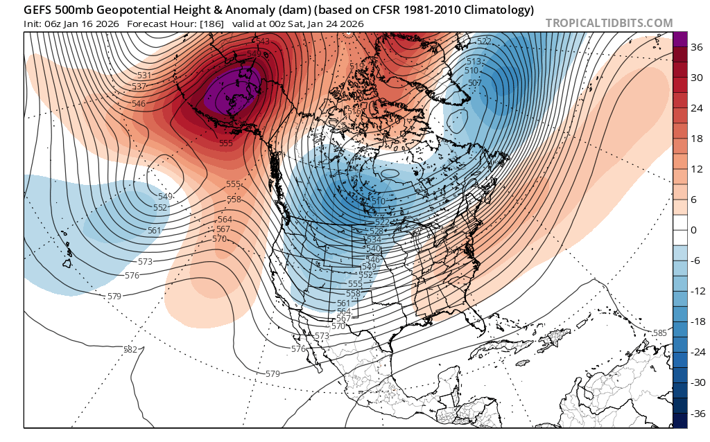
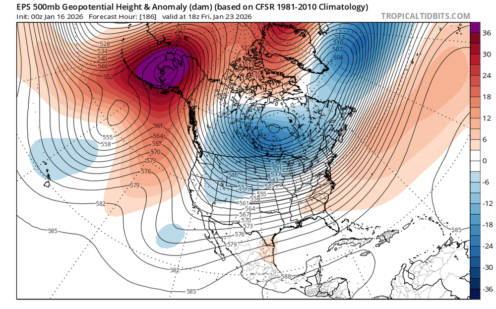
I think the key next week will be how deep a trough we can get out West. All winter long the models have been too aggressive in digging those troughs beyond 168 hrs So we actually need the Southeast ridge to put up some resistance so the overrunning doesn’t get suppressed. The EPS doesn’t dig as much energy into the west so it’s less amped up with the overrunning in the East. It’s been a while since once of these overrunning set ups produced more than 4” from EWR to ISP. But we saw how back in December we finally got two clippers to work out for 4”+. So maybe it’s possible we can finally get a decent overrunning event here. But it’s still way too early to know for sure exactly where the nest overrunning zone sets up. We really want to get to within the 120hr mark for the details to come into clearer focus. But at least the potential is there. Whether the potential gets realized is another story. EPS diggs less energy west so overrunning is further south than GEFS

-

First Legit Storm Potential of the Season Upon Us
WeatherGeek2025 replied to 40/70 Benchmark's topic in New England
gm euro should come in on board by 0z run tonight -

January 2026 regional war/obs/disco thread
Baroclinic Zone replied to Baroclinic Zone's topic in New England
That’s funny. My first storm lurking the old EUSWx site was the January 2005 blizzard. -

January 2026 regional war/obs/disco thread
40/70 Benchmark replied to Baroclinic Zone's topic in New England
I will go out on a limb and say this one will end better than last year. -
First Legit Storm Potential of the Season Upon Us
Baroclinic Zone replied to 40/70 Benchmark's topic in New England
630 AFD. Even BOX unsure with AI models -
2025-2026 ENSO
40/70 Benchmark replied to 40/70 Benchmark's topic in Weather Forecasting and Discussion
Yea, not surprising to you, Chris or me. -
2025-2026 ENSO
40/70 Benchmark replied to 40/70 Benchmark's topic in Weather Forecasting and Discussion
I was torn on whether to include 2013 in my February composite, but I ultimately decided against it because of this....that said, we still have at least a brief El Nino like interlude coming up later this month.... My three worst outlooks were 2018-2019, 2019-2020 and 2023-2024, but I am confident that I had I known what I do now, then would have been much better in large part to your musings. Great stuff, as always, Chris. -
Well, the EURO 25 threat survived 00z, but much weaker and strung out with less UL support. I dropped from 12 inches to 5 as a measure of strength. I'm a little surprised that it survived! And now the GFS jumps into the fray for a very active last 10 days of January. Bring on the 10:1 stuff. I don't want to measure more dust.
-
Never should have been started…
-
First Legit Storm Potential of the Season Upon Us
Baroclinic Zone replied to 40/70 Benchmark's topic in New England
Seems like op euro and eps are the lone outliers at this point to a moderate impact event. Skynet is more in line with rest of guidance. Solid overnight 12hr trend in the positive. -

January 2026 regional war/obs/disco thread
WinterWolf replied to Baroclinic Zone's topic in New England
But This would be during the day…at 1pm though. That map was high temps at -16f. Again, that would be all time brutality. Not happening like that imo. But if it does, just wow. -

January 2026 Medium/Long Range Discussion
RevWarReenactor replied to snowfan's topic in Mid Atlantic
I don't even know much about the science behind it all, and I am a pessimist, but even for me its obvious the potential is there this year. This year has actually been "good". No shutouts, no endless SE ridge and torch. Its obvious the upcoming couple weeks are our best opportunity in years and if we actually walk away from it with nothing, like PSU said, time for a new hobby. -
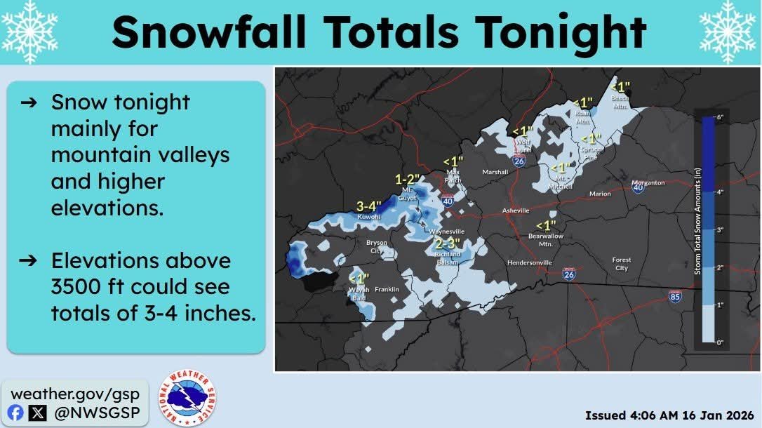
Ohio folks would like to see that map verify
-
Another Coating of Snow Saturday - "It's all we Got"
WinterWolf replied to Sey-Mour Snow's topic in New England
Sunday is still trending bro…it’s not done. More Changes coming. -
https://www.weather.gov/phi/new_afd1
-

January 2026 regional war/obs/disco thread
DavisStraight replied to Baroclinic Zone's topic in New England
It happens from time to time, I was just looking at a picture on my computer of my therm at -16. I think it was about 10 years ago or so. -
The differences between rgem, gfs and euro are pretty hilarious for being only 54-60hrs out.
-
Thats what we need! A strong ridge in the NAO will suppress or swing it S and E. A relax in that feature will help us. Heather Archambault event?
-
GSP Sent from my SM-G998U using Tapatalk

-
The non-AI GFS isn’t actually that far off from the AIGFS at 06z. I don’t really trust AI precip fields as they’re not typically trained for those, but its actually not too far off from the op.
-

2025-2026 Fall/Winter Mountain Thread
ncjoaquin replied to Buckethead's topic in Southeastern States
Made it down to 10.9. Steadily rising this morning, though. 15.6 presently. Still not given up on the weekend system. It wouldn't take much to work in our favor. Good luck to the SW mountain people tonight. -
I'll take my chances with temp issues any day out here but it sure does seem like we have a moisture problem. Im going to need to speak to the manager about that
-

Another Coating of Snow Saturday - "It's all we Got"
Damage In Tolland replied to Sey-Mour Snow's topic in New England
Sunday will be a few inches of fluff which blows away /sublimates. I was so looking forward to snow tomorrow -
Another Coating of Snow Saturday - "It's all we Got"
WinterWolf replied to Sey-Mour Snow's topic in New England
Kev, if sacrificing Saturday can bring a region wide significant event Sunday night/Monday, that’s a no brainer.