All Activity
- Past hour
-

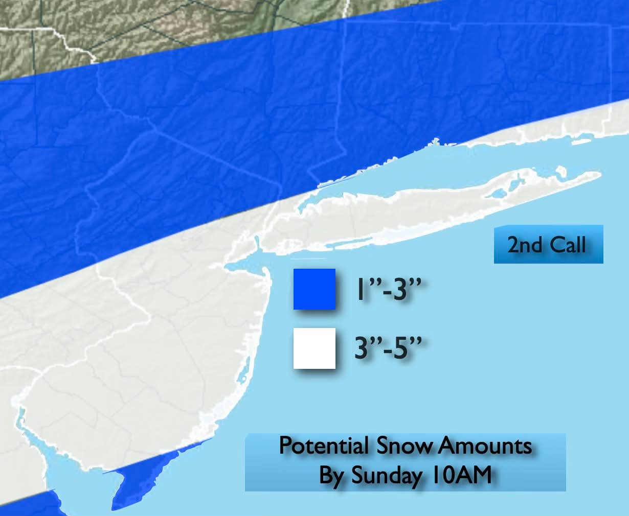
Minor snowfall sunday 12/14/25 1-4” possible
MJO812 replied to WeatherGeek2025's topic in New York City Metro
John Marshall
-
Appears to be.
-
One more Arctic outbreak before the pattern moderates.
-
The cold this year hits deeper into my bones vs previous years. It's probably because im getting older but still
-

12/14: Sunday funday? Will the south win again?
DDweatherman replied to TSSN+'s topic in Mid Atlantic
Yeah the 6z euro getting the 2” to my yard is an accomplishment for sure. My hopes were solely resting on the high resolution (and also low performing at times) models. -

December 2025 regional war/obs/disco thread
Ginx snewx replied to Torch Tiger's topic in New England
Add GFS GEFS EPS Christmas week, if the cold is locking the the weather will be rocking -

December 14th - Snow showers or Plowable snow?
tavwtby replied to Sey-Mour Snow's topic in New England
I wouldn't be shocked if someone in SE areas of SNE saw 6" of fluff, column will be plenty cold in the DGZ for so good growth, a few more tics north we can all be in business -
It's literally gone from being able to see the cloud deck to our east to a few flurries to 1-2" and back. Almost game time so buckle up buttercup
-
December 14th - Snow showers or Plowable snow?
Ginx snewx replied to Sey-Mour Snow's topic in New England
6z Euro and blended models fluff it up.png.cbcf8079294cbc4968e63ba67736c324.png)
.png.1a65876edb976fefbae2f7ed549398f2.png)
-
Looks like we might be getting a little snow later on this evening the decorations should look nice outside in the morning
-

Central PA Winter 25/26 Discussion and Obs
mahantango#1 replied to MAG5035's topic in Upstate New York/Pennsylvania
-
I’ll be happy with 1 the way this has oscillated for us
-
Minor snowfall sunday 12/14/25 1-4” possible
MJO812 replied to WeatherGeek2025's topic in New York City Metro
RRFS A.thumb.png.6cd898c190c7005b897ae93673f7f676.png)
-
0z euro has Christmas Eve snow
-

December 14th - Snow showers or Plowable snow?
Damage In Tolland replied to Sey-Mour Snow's topic in New England
Great trends overnight -

December 11th-14th Double Banger Clippers
Chambana replied to Jackstraw's topic in Lakes/Ohio Valley
CMI jackpot today? Going 5.5” final call. -
Nail biter until the end with this one for us
-
LWX probably weighing watches or warnings for Cecil and Harford?
-
Euro also
-
Euro looking a lot like Rap and Hrrr, but with its typical drier solution.
-
Kuchie
.thumb.png.62e2edb6bd98ae78e6283c814c8edd81.png)
-

December 2025 regional war/obs/disco thread
mahk_webstah replied to Torch Tiger's topic in New England
Seems like the cooldown after a few warm days is still on target for just before Christmas? And with snow chances -
Minor snowfall sunday 12/14/25 1-4” possible
MJO812 replied to WeatherGeek2025's topic in New York City Metro
6z aifs bumped north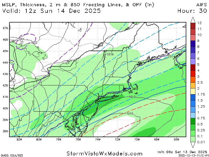
-
December 2025 regional war/obs/disco thread
mahk_webstah replied to Torch Tiger's topic in New England
I’m talking about the low that’s over Newfoundland. Move it 250 miles northeast allows a storm to climb the coast doesn’t it? And even stall with all that blocking. -
Way too much cold air to the north to be a blowtorch pattern


.png.a0d3ba9afc8dcdfef5fae7f6f48b2ef7.png)


.png.001254a48e7779813e35229a4b0972bc.png)
