All Activity
- Past hour
-

September 2025 OBS-Discussion centered NYC subforum
SACRUS replied to wdrag's topic in New York City Metro
-
September 2025 OBS-Discussion centered NYC subforum
SACRUS replied to wdrag's topic in New York City Metro
Records: Highs: EWR: 98 (2018) NYC: 97 (1881) LGA: 96 (2018) JFK: 93 (2023) Lows: EWR: 48 (1938) NYC: 48 (1924) LGA: 53 (1988) JFK: 52 (1963) Historical: 1667: The “dreadful hurricane of 1667” is considered one of the most severe hurricanes ever to strike Virginia. On the first, this same storm was reported in the Lesser Antilles. The hurricane devastated St. Christopher as no other storm had done before. The "great storm" went on to strike the northern Outer Banks of North Carolina and southeastern Virginia. Area crops (including corn and tobacco) were beaten into the ground. 1776: Called the Pointe-à-Pitre hurricane, this storm is one of the deadliest Atlantic hurricanes on record. While the intensity and complete track are unknown, this storm struck Guadeloupe on this day, killing 6,000. 1881 - Forest fires in Michigan and Ontario resulted in 'Yellow Day' in the northeastern U.S. Twenty villages in Michigan burned, and a total of 500 persons were killed. Fires caused 2.3 million dollars in losses near Lake Huron. Candles were needed at the noon hour. (David Ludlum) 1881: Forest fires in “The Thumb” of Michigan and Ontario resulted in “Yellow Day” over the New England states. Twenty villages and over a million acres burned in Michigan. The smoke from these fires caused the sky to appear yellow over several New England cities. Twilight appeared at noon on this day. 1929 - Iowa's earliest snow of record occurred as a few flakes were noted at 9 AM at Alton. (The Weather Channel) 1933: The remnant low of the Treasure Coast Hurricane dumped 10.33" of rain in Charleston, which is the second-highest 24-hour rainfall total on record for the downtown station. The storm produced wind gusts of 51 mph and also spawned a tornado near the city. 1987 - Thunderstorms produced more than seven inches of rain in Georgia. Four persons drowned, and two others suffered injury, as three couples attempted to cross Mills Stone Creek at Echols Mill in their automobile. Smoke from forest fires in California and Oregon spread across Utah into western Colorado. (The National Weather Summary) (Storm Data) 1988 - Unseasonably cool weather prevailed across the north central and northeastern U.S. Thirty cities reported record low temperatures for the date, including Saint Joseph MO with a reading of 38 degrees. A low of 44 degrees at Indianapolis IN was their coolest reading of record for so early in the season. The mercury dipped to 31 degrees at Hibbing MN and Philips WI. (The National Weather Summary) 1989 - An early afternoon thunderstorm produced wind gusts to 104 mph at Winterhaven, FL, flipping over four airplanes, and damaging five others. The high winds also damaged a hangar and three other buildings. A cold front produced strong winds and blowing dust in the Northern High Plains, with gusts to 54 mph reported at Buffalo SD. Powerful Hurricane Gabrielle and strong easterly winds combined to create waves up to ten feet high along the southern half of the Atlantic coast. (The National Weather Summary) (Storm Data) 2003: Hurricane Isabel was first named on September 6th, 2003. It would reach Category 5 status and eventually make landfall in North Carolina as a Category 2. 2017: Category 5 Hurricane Irma affected the US Virgin Island and Puerto Rico. Maximum sustained winds were at 180 mph when the storm hit St. Thomas & St. John. Catastrophic damage was reported over the US Virgin Island & significant damage over Puerto Rico, especially over Culebra. -
September 2025 OBS-Discussion centered NYC subforum
SACRUS replied to wdrag's topic in New York City Metro
86 / 70 clouds pushing east - race to 90 in the hottest spots. Onshore flow this week keeps it near normal, overall warmer by nexy weekend / mid month and beyond. https://cdn.star.nesdis.noaa.gov/GOES19/ABI/SECTOR/eus/02/GOES19-EUS-02-1000x1000.gif -
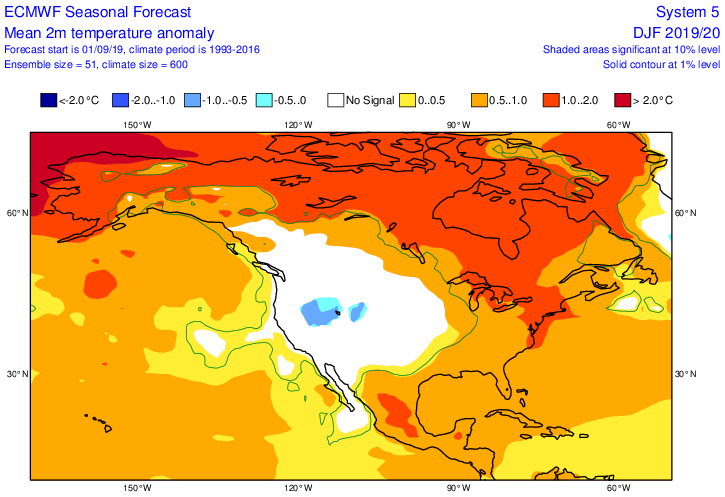
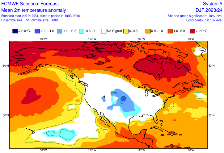
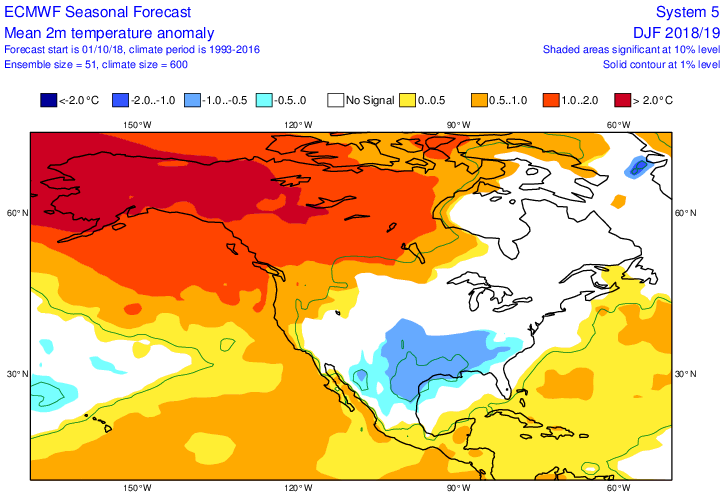
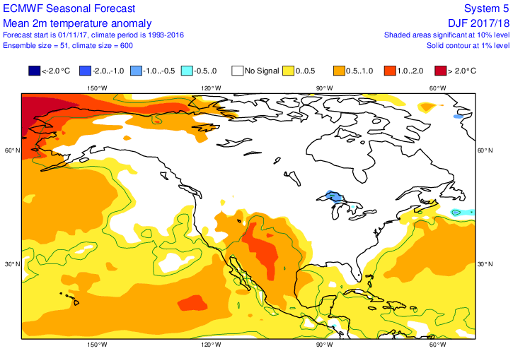
Regarding all 9 Euro DJF fcasts issued in Sept since 2017-8 (as far back as can be seen at the Euro site), there wasn’t even a tiny speck of BN anywhere in the lower 48 E of 110W long. The only one that had any BN anywhere in the lower 48 was the 2019-20 fcast, which had a small area of ~-1F in a small part of the Mtn W (which amazingly enough ended up being the only area with BN): Despite that, there were notable areas of actual BN in portions of the lower 48 in all of these DJFs except 2019-20 and 2023-4. So, your statement ECM is now incapable of seeing below normal temps has essentially been true for its Sept fcasts since 2017-8. However, two of its 8 Oct fcasts and one of its Nov fcasts for DJF did have some BN: Oct ‘23, which failed as there was no BN in the lower 48: Oct ‘18, which got the BN in KS right but the rest of this BN area ended up NN or AN and also it missed the widespread BN in NW 1/2 of the US: Nov ‘17 in UP of Mich, which was correct, but it missed the widespread BN in the Midwest, Plains, and N Rockies:
-
What a disaster of a Saturday. Steady synoptic rain, 1/3rd of an inch so far. 55F at 1500ft here at the mountain and 59F down at the ASOS. 50s and rain, just like a January thaw.
-
.thumb.png.4150b06c63a21f61052e47a612bf1818.png)
Saturday 9/6 Strong/Severe storm potential
HIPPYVALLEY replied to Torch Tiger's topic in New England
Like @radarmansaid, TF airport or Poets Seat tower in Greenfield is awesome. You can drive up to the top of that hill and there’s five or six parking spots and a stone tower you can climb. Great views in all directions. -
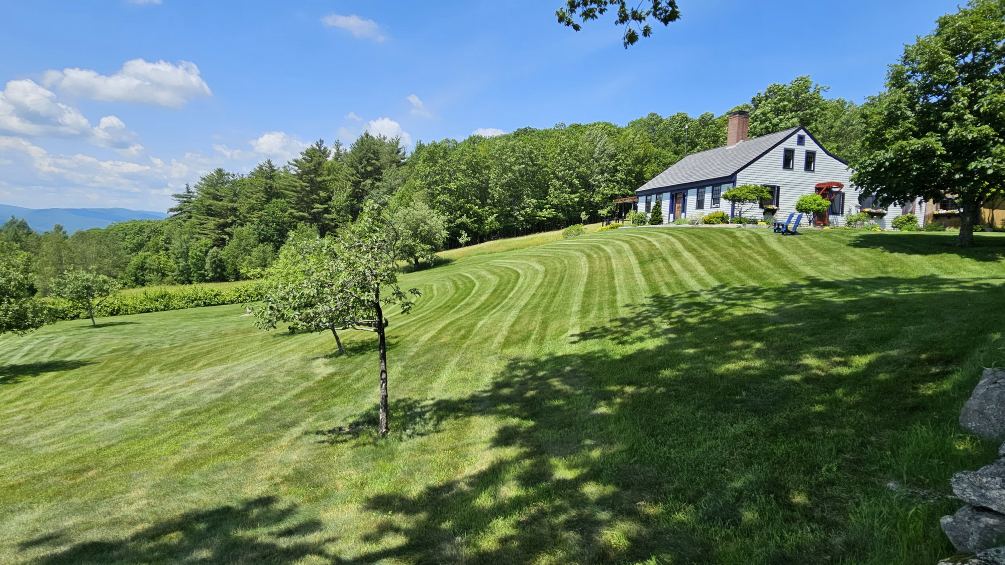
Bring on the rain. First picture was June 16th.

-

September 2025 OBS-Discussion centered NYC subforum
Brasiluvsnow replied to wdrag's topic in New York City Metro
Thanks -
Probably - history repeats itself.
-
It’s sooo dry, we got 0.01-0.05 on Thursday, but before that it was august 19th since the last rainfall, and that was around a quarter. Today doesn’t seem too promising in the NNK.
-
Thanks! I'm not too worried about being able to move easily. Once I pick a spot and location I don't really want to have to deal with moving and trying to get somewhere or follow the storm.
-

September 2025 OBS-Discussion centered NYC subforum
wdrag replied to wdrag's topic in New York City Metro
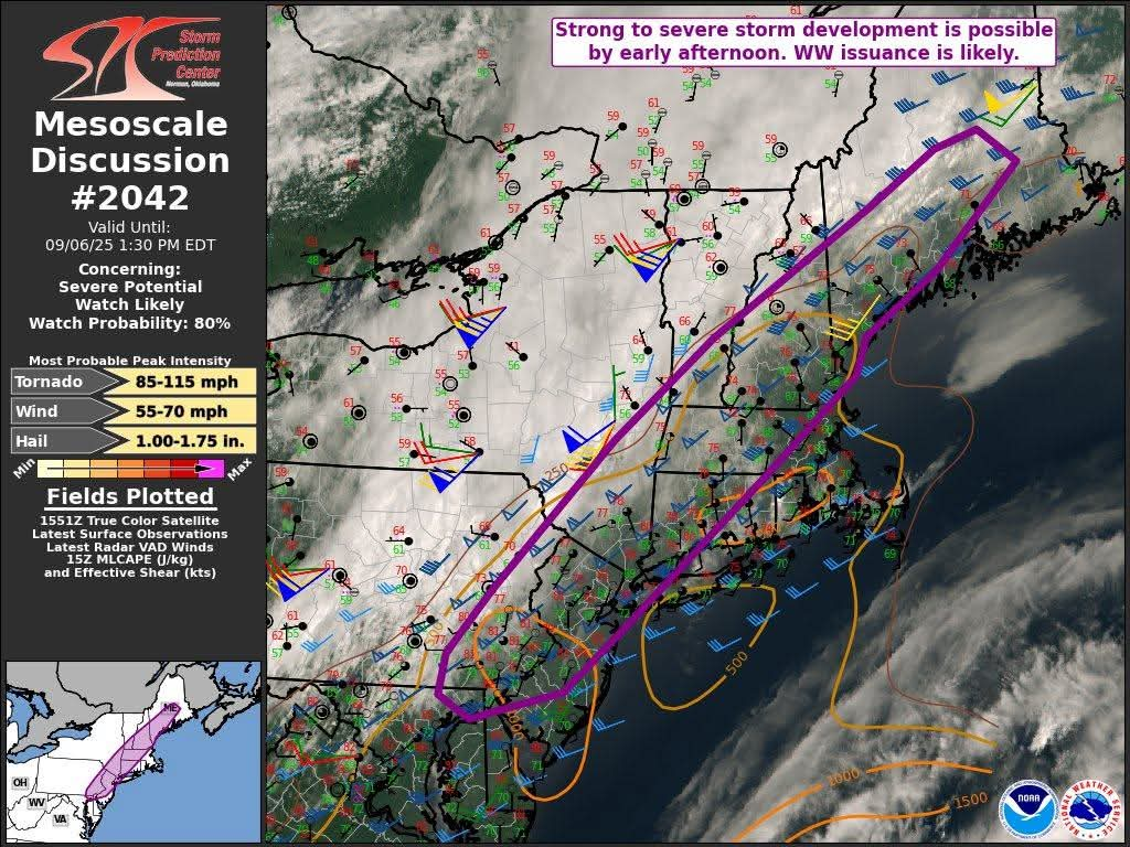
Thank you. 12z SPC HREF is saying it will happen up and down the I95 corridor. Bring your swimmies if you're outside and dry clothes for inside. 80% prob of watch issuance in latest convective outlook up and down I95. Will probably issue NOW-OBS thread 130PM if not sooner. This will be significant for some folks. -
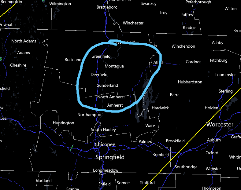
Turners Falls airport is a good spot. Or on the top of Mt Sugarloaf (which you can drive up), except you aren't in position to move easily. Fields between North Amherst and North Hadley too, wide open fields over there.
-
Something’s wrong with the processing, probably. That’s upwards of 30dbz in precip mode.
-
Hoping for something good here.. suns out
-

September 2025 OBS-Discussion centered NYC subforum
Stormlover74 replied to wdrag's topic in New York City Metro
https://www.spc.noaa.gov/products/md/md2042.html
-

Saturday 9/6 Strong/Severe storm potential
Torch Tiger replied to Torch Tiger's topic in New England
convection looks shallow and meh. hope that ramps up soon -
Does anyone know of any really good viewing spots in this area? Debating on what to do but time is a wasting. The area I would go in southwest New Hampshire would definitely be best but my worry is the best stuff will go from Berkshire through northern Mass, just south of the VT/NH border.
-

Saturday 9/6 Strong/Severe storm potential
Chrisrotary12 replied to Torch Tiger's topic in New England
Need a link to our posters cam up there. -

September 2025 OBS-Discussion centered NYC subforum
psv88 replied to wdrag's topic in New York City Metro
Saw that. Meh -

September 2025 OBS-Discussion centered NYC subforum
forkyfork replied to wdrag's topic in New York City Metro
i wonder if smoke will be an issue for daytime convection and our best rain comes with the better lift tonight -
I was thinking Bristol to Moultonborough so yeah…same wavelength.
-
Looks like the first wave got some of north central PA and into Scranton and the Endless Mountain region. Now watch. Wave #2 will form southeast of I-81 and hammer Lancaster, Reading, the Lehigh Valley, and points east and south. Just like every opportunity before it.
-
12z HRRR
-
Saturday 9/6 Strong/Severe storm potential
Chrisrotary12 replied to Torch Tiger's topic in New England
Feel like I’m too far east.