All Activity
- Past hour
-

Hurricane Erin - 75 mph - 993 mb - WNW @ 17
WxWatcher007 replied to BarryStantonGBP's topic in Tropical Headquarters
Recon approaching for another center pass. We’ll see just how quickly this is intensifying shortly. -

2025 Atlantic Hurricane Season
LongBeachSurfFreak replied to BarryStantonGBP's topic in Tropical Headquarters
Heading into peak with above normal water temps in all but the far east MDR anything is possible. -
Cedar Rapids getting smoked pretty good
-
big 'un on the wild 18z gfs

-
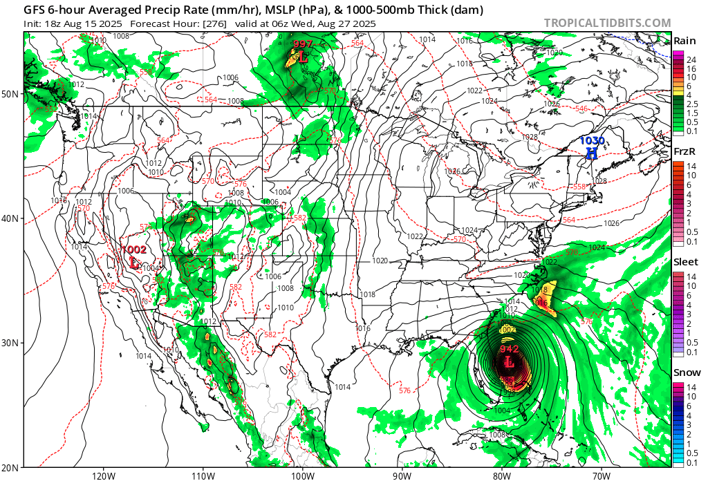
IF that happens, the seasonal ACE would reach ~34 as of 8/22. If then another multiday hurricane were to closely follow Erin like the GFS/GEFS are suggesting could occur, having 50ish ACE by the end of August would be a reasonable possibility especially considering there could easily abe an additional weaker storm or two, which would out 2025 notably above the normal ACE through August.
-
Greensboro was swimming in it last July
-
"It's dead Jim" Latest one has it as 0/0.
- 42 replies
-
- 1
-

-
- lower texas coast
- ne mexico
- (and 3 more)
-

2025 Short Range Severe Weather Discussion
hawkeye_wx replied to Chicago Storm's topic in Lakes/Ohio Valley
Models did a terrible job forecasting this. The HRRR literally had nothing making it to eastern Iowa only a few hours ago. The RRFS had something small passing across northeast Iowa. -
It’s getting dark in the N sky here and the radar says strong thunderstorms are on the way as an outflow boundary is coming through: SPECIAL WEATHER STATEMENT NATIONAL WEATHER SERVICE CHARLESTON SC 635 PM EDT FRI AUG 15 2025 GAZ118-119-SCZ047-051-152330- COASTAL CHATHAM GA-INLAND CHATHAM GA-COASTAL JASPER SC-INLAND JASPER SC- 635 PM EDT FRI AUG 15 2025 ...A STRONG THUNDERSTORM WILL IMPACT JASPER AND CHATHAM COUNTIES UNTIL 730 PM EDT... AT 635 PM EDT, DOPPLER RADAR WAS TRACKING A STRONG THUNDERSTORM NEAR BELLINGER HILL AREA, MOVING SOUTHWEST AT 15 MPH. HAZARD...WIND GUSTS UP TO 50 MPH AND PENNY SIZE HAIL. SOURCE...RADAR INDICATED. IMPACT...GUSTY WINDS COULD KNOCK DOWN TREE LIMBS AND BLOW AROUND UNSECURED OBJECTS. MINOR DAMAGE TO OUTDOOR OBJECTS IS POSSIBLE. LOCATIONS IMPACTED INCLUDE... POOLER, BLUFFTON, HUTCHINSON ISLAND, DOWNTOWN SAVANNAH, BELLINGER HILL AREA, SAVANNAH INTERNATIONAL AIRPORT, GODLEY STATION, WILMINGTON ISLAND, GARDEN CITY AND PORT WENTWORTH.
-

2025 Short Range Severe Weather Discussion
Chicago Storm replied to Chicago Storm's topic in Lakes/Ohio Valley
debt repayment has been completed. final total paid...5 years. -
2025 Short Range Severe Weather Discussion
hawkeye_wx replied to Chicago Storm's topic in Lakes/Ohio Valley
Holy cow, what a storm! This reminds me of the derecho. It briefly poured half-inch size hail, then 70 mph wind blasted through. I couldn't even see the houses across the street. Thankfully, our hail was only half-inch size. A spotter only a mile away reported ping-pong ball size. -
Considerable severe thunderstorm warning for Iowa
-

Hurricane Erin - 75 mph - 993 mb - WNW @ 17
Wannabehippie replied to BarryStantonGBP's topic in Tropical Headquarters
5:00 PM AST Fri Aug 15 Location: 18.9°N 57.6°W Moving: WNW at 17 mph Min pressure: 993 mb Max sustained: 75 mph -

2025-2026 ENSO
so_whats_happening replied to 40/70 Benchmark's topic in Weather Forecasting and Discussion
Seems reasonable the atmosphere looks really nice coming up and in a good warm pocket. Should at least get 3 days of major hurricane status. -
I'm 'bout to sell the house and move to Cedar Rapids lol.
-
For the last six weeks, we have gotten everything. Today was a nothingburger, but the storms have way outperformed the model forecast. It is dark as night right now as the storms move in.
-

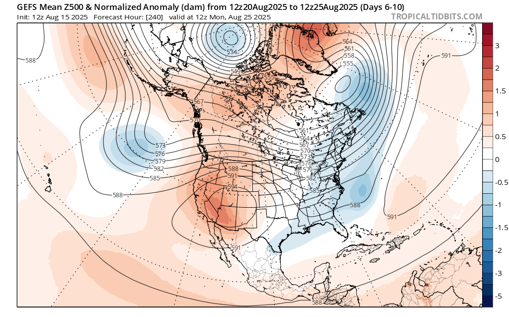
Mountain West Discussion
donsutherland1 replied to mayjawintastawm's topic in Central/Western States
Today, the low temperature at Phoenix was only 76, its coolest since June 4 due to some monsoonal moisture. -
It was a top 5 wx event . For an extreme wx fanatic like me .. I love for it. As boring as it’s been the last 5-10 years . It’s all we’ve got. Did the sound play on the strike?
-
Lol you said maybe
-
Well, sometime after I made my post, we jumped enough to actually go above true 90.
-
2025 Atlantic Hurricane Season
WxWatcher007 replied to BarryStantonGBP's topic in Tropical Headquarters
Yeah, zero concern in the long range from me right now. As we saw with Erin, these long range model runs aren’t good for much.. - Today
-
This little meandering rain shower just to the north of Harrisburg can’t make its mind up on which direction that it wants to go this evening. Marysville got .13 of rain so far today.
-
Probably looking high temps upper 70s to low 80s with reasonable dewpoints if this verifies.

-
Wasn't expecting to be under a severe thunderstorm watch today. Looks like yet another round of heavy thunderstorms for DVN's northwestern CWA. Expecting a nice round of anvil rain later from the leftovers lol.
-
Neat, too close for comfort ! That must have been one loud bang!